RETIREMENT TRIP #6
A MOUNTAN NAMED RYAN
October 2015
At
8:30 a.m. it’s a delightful breezy 72 degrees in Twenty-Nine Palms.
 |
| From the trail up Ryan's Mountain, huge monzo-granite boulders on the valley floor look like piles of pebbles. |
“This
town hasn’t changed too much in the last five years,” said Andy. All the growth is up the other way. When
Andy pulled into the Ryan’s Mountain parking lot at 9:00 a.m., the temperature
read 65 degrees. I pulled on a jacket,
and he grabbed the backpack. The trail
guide rated the climb as strenuous—a one-and-a-half-mile steep climb to the top
that takes most average people one-and-a-half to two-and-a-half hours. But Ryan’s Mountain is the most popular hike
in the park.
 |
| From Ryan's Mountain Trail looking far across the valley near Palm Springs, Mount San Jocinto rises above surrounding peaks to 10,504 feet. |
 |
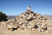
| Perched on the "memorial" pile of rocks, Andy reigns temporarily as conqueror of Ryan's Mountain. |
“I’m
adding my touch,” said Andy, placing a rock on the pile at the top, “and one
for you.” Gently he put two more pieces
of stone on the huge collection already there.
We had left our mark on Ryan’s Mountain, along with a whole host of
others. Holding our hats, we checked out
the 360-degree view. With the world beneath us, we were alone on the pinnacle.
 |
| Chilly but sunny, the summit offers peace and solitude. |
 |
| Descending takes us half the time and effort as the climb up. |
I
stripped off my jacket back at the car.
The whole three miles had taken us two hours and five minutes, including
time for photographs, chatting and browsing at the top. Pretty good for a couple of old timers! And now it was 84 degrees.
From
White Tank Campground we followed the half-mile Arch Rock Nature Trail in a
loop through the boulders. I even squeezed in between the rough granite for
footing to climb to the arch. I made it,
but unfortunately two young men were taking time-lapse shots from the center of
the arch. It kind of spoiled my pictures but I did the best I could. They were there first. Shakiti Na Gai! A trail sign here said the
monzo-granite intrusion occurred 135 million to 155 million years ago when
dinosaurs roamed the area. |
| The Cholla Cactus Garden thrives in a very limited elevation and climatic zone. |
 |
| Staying away from the threatening spines of any teddy bear cacti,we stop to read the nature pamphlet. |
The quarter-mile Bajada Trail identified plants of the Sonora Colorado Desert. I took a picture of a plant that looked totally dead like many other piles of sticks in this area of the park, but I still haven't been able to identify the name. The sign explained that this plant has tubular red flowers that attract hummingbirds after it rains. Like many desert plants it drops its leaves to conserve moisture in dry times.
 |
| At Cottonwood Spring, a natural oasis in the desert, the tall cottonwood competes with palms for water and sunlight. |
“This
whole area at the South end of the park is different from the rest,” said Andy,
as we headed back toward the interior. No Joshua trees at these lower
elevations and many dry washes draining the lifeless slopes. Palo verde and ironwood have a foothold on
the bajadas, slopes at the bases of mountains at lower elevations.
 |
| Heavy with leaves, an ocotillo in the wash near the side of the road in Joshua Tree, shows evidence of recent rainfall up-canyon. |
 |
| Pleasant and refreshing in the shade Cottonwood Spring attracts life now, just as it did for Cahuilla Indians a couple centuries ago. |
“That was a pleasant surprise,” said Andy, as we pulled in. Palm trees at least a hundred feet tall, towered above us in a small cluster. Fan palms spread wide beneath them and a giant cottonwood intertwined, reaching up straight and tall for sunlight. Cahuilla Indians lived here and used the granite boulders as mano and metate, after gathering native plants from the desert for food. The presence of water produces wonders, and the contrast was especially sharp after walking through the bajada, where everything looked dead.
But here too was “death.” Signs warned visitors not to deviate from the
short trail. The area had been totally
contaminated with arsenic, lead and other hazardous metals from the abandoned
mines up the wash.
Dagger yuccas popped up as we drove back toward the higher elevations and Pinto Basin.
Dagger yuccas popped up as we drove back toward the higher elevations and Pinto Basin.
At
mile 12 we found a grove of ocotillo.
The ones close to the dry wash had leaves—some heavy with foliage. Some across the road were already dry and
brown. It was an amazing contrast in so
limited an area. It just shows what a
little water can do.
National
Park Way is the new main entrance to Joshua Tree National Park. “They did a nice job,” said Andy.
 |
| Steel sculptures highlight the median divider along National Park Way at the new main entrance to Joshua Tree National Park. |
I
agreed.
In
the late afternoon we drove to Marengo to walk the boardwalk at the Big Marengo
Wildlife Preserve, a natural oasis in the desert. |
| The recently completed National Park Way welcomes visitors with class and style. |

No comments:
Post a Comment