Pages

Friday, October 7, 2016

RETIREMENT TRIP #7
Fire and Water: The End of the Trail
                                                           When we left the motel this morning, the mountain peaks were clear, except for a small layer of clouds behind them.
The morning sun casts shadows on the mountains as
the old wagons of Stanley, Idaho, sit at rest.
According to the motel clerk, “if you can see a peak here, we call it ‘clear’.”
From the Dead End street in Stanley,
we watch the sun
come up to light the mountains.
With pines in the darkened shadows
of early morning, the peaks
around Stanley stand out in the sun.
Andy pulled into the Dead End street with the old wagon in Stanley, then stopped along the main road just outside of town, then pulled over by a ranch where cows grazed and finally picked an open field where the mountains showed through the pine trees.
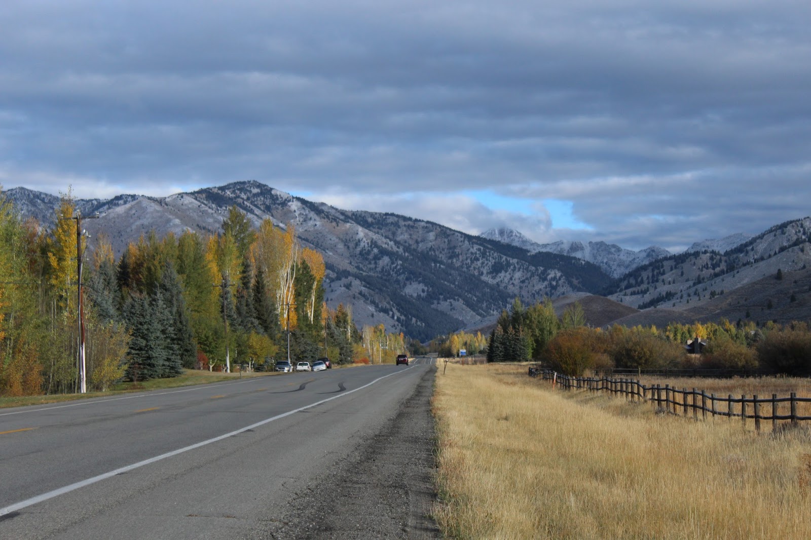
Farther down the road from Stanley, views are magnificent.
Each time I hopped out with one camera, took pictures, grabbed the other camera, took more pictures and jumped back in the car to warm up.   It was 31 degrees.
“I’m putting on my fleece jacket next stop,” I told him.  The sweater alone wasn’t cutting it!  Worst off were my fingers!
Unaware of the scenery, cows graze
peacefully near the main road.
Andy sat in the car with the motor running, but he checked the shots each time.
Peaks near Stanley are snow-coated
by early October. Winter has come here.
“I’m looking for a sign to Stanley Lakes,” he said, when we had resumed the drive.
With each stop the clouds had increased, and there was less and less sun on the peaks.
Outside of Stanley, peaks rise in
silence in the cold October air.
Most of the Stanley Lake campgrounds were gated, but people cooked breakfast at the one that was open.  We watched from the overview lookout.
The sun still highlights the peaks as we head away from Stanley. 
Andy read the signs, as I snapped away, trying to capture reflections on the water before we lost the sun completely.
Clouds hug the shore of Stanley Lake at the base of McGown
Peak, already draped in snow.
McGown Peak, 9.860 feet and already snow-covered on October 7, was named for the McGown brothers who were cattle ranchers in the area.  They drove their herds past the mountain.
From the campground, McGown
Peak, with glaciers showing,
towers high over the landscape.
Beautiful Stanley Lake, at the foot of the McGown Peak, was named for Prospector Captain John Stanley who explored the lake in 1863.  The peak, a granite intrusion, was uplifted and carved by glaciers, so the shoreline of the lake is glacial moraine.
In the cold morning air, a cloud hangs low at McGown Peak.

Stanley Lake reflects McGown Peak in the early morning sun.
We walked around the lookout along the lake, noticing a couple anglers in boats on the water in the early morning, hearing a young boy call to his father at a camp site, feeling the frost on the railing.
Clouds had blanketed almost the whole sky.  The sun on the peaks was gone.  We had lost the reflection of the mountains on the water.  It was time to move on.
An hour later and a few thousand feet lower in elevation, the sun peaked through again.
We were coming out of the mountains.  “They make their own weather,” said Andy.  Cold weather, that is.  The prediction for Boise was 74.
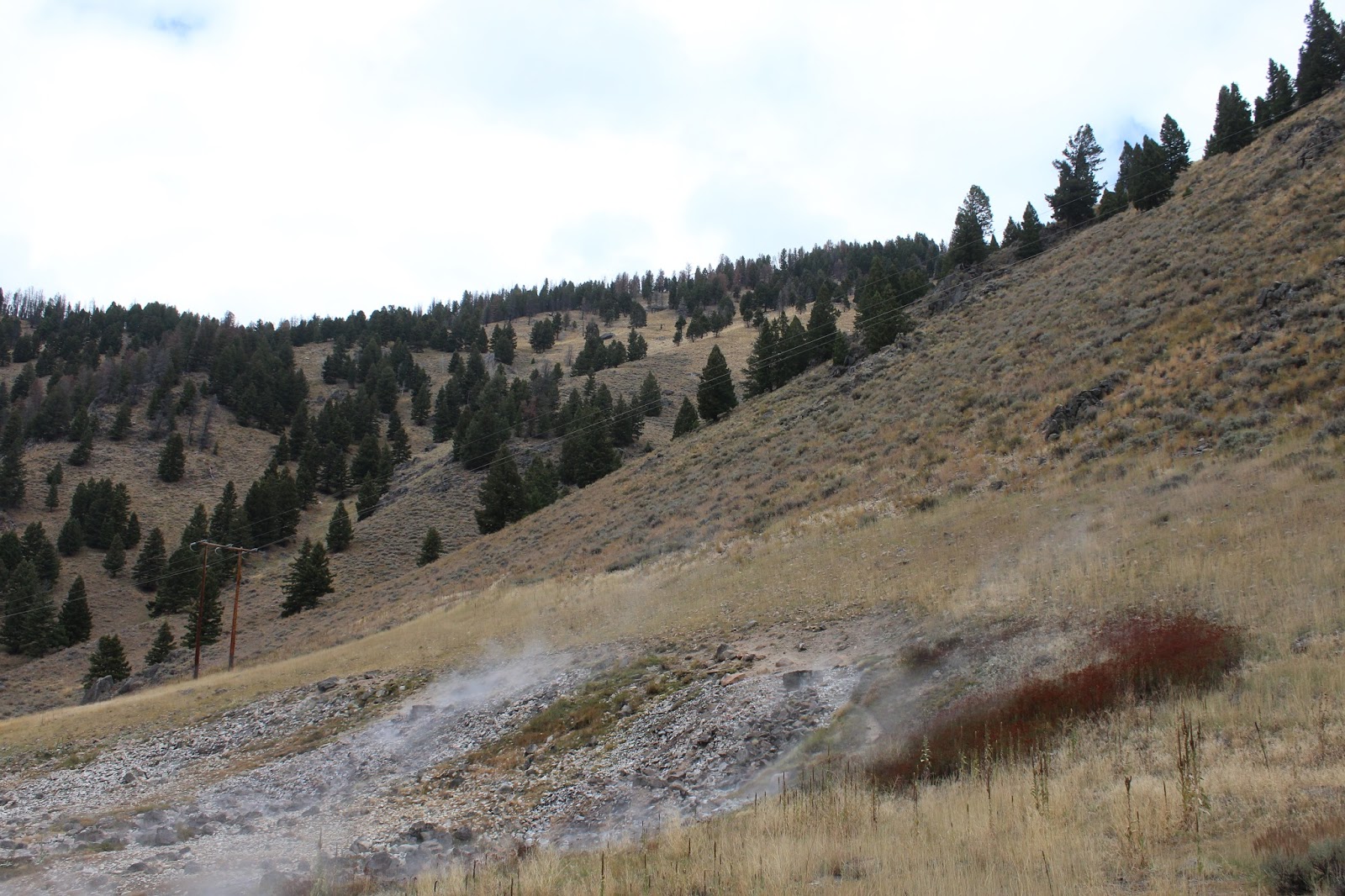
Kirkham Hot Springs at Boise National Forest Campground entertained a number of camping trailers.  But there were no signs of life.  Families were all dabbling and wading and soaking in the Hot Springs.  Steam rose in waves and water streamed from the gravel banks into greenish pools before tumbling to the South Fork of the Payette River.
Steam rises from the bankside of the Payette River.
“No dogs, no dishes, no nudity” read the campground signs.  That was in reference to Hot Springs bathing.
Adjoining hills and the mountainsides for some miles before the Hot Springs showed severe fire damage.  We looked at the signs; the fire occurred in 1989.  Even though there is some low growth, the area has not recovered.  It’s a sad sight to see burned out hills and avalanche-prone slopes in this ruggedly beautiful country.  That fire got so hot it actually created a funnel cloud in the narrow valley.
On the way back up the slope out of the Boise National Forest, we drove past a new burn.  “This just occurred this year, I’d guess,” said Andy, “and it was an unusually low fire year.”
The Pioneer Fire destroys thousands
of acres of forest in 2016.
We could still smell the char with the windows closed, and the devastation extended for miles.  We read later that it was the Pioneer Fire of 2016.  It had burned more than 1,300 acres at first report. More than 300 firefighters battled the blaze that started on July 21st.  Hot and dry conditions contributed to the spread.
The front of the old Wells Fargo
office reflects the atmosphere of the
old mining town of Idaho City.
The fire continued to burn.  And this year as of September 12, it had consumed 185,895 acres in two months and was only 56% contained.  Cooler temperatures and northwest winds were expected to slow the advance and aid containment efforts.
“I heard the federal government has been spending 1.8 billion dollars a year to fight fires in the West,” said Andy, “and that’s not what state governments contribute.”
In Idaho City, Sue poses
with a local outside
the local saloon.
Most of the burned trees here weren’t ready to be harvested by lumber companies.  So most of the burn is total loss.
Mores Creek Summit, at 6,118 feet, was the dividing line.  The Boise side wasn’t burned at all.  No charcoal, no smell and suddenly patches of blue sky.  Some of the curves and bends were 25 m.p.h. speed limit with elevation changes of 4,000 feet twice.  And Route #21 is the main highway. No wonder the advertising said Stanley was remote and removed!
We stopped at the Sarsaparilla Ice Cream store in Idaho City, population 458, for coffee.  “This was an old mining town,” said Andy.  Diamond Lil’s Restaurant and Saloon was closed, for sale by owner, appointment only.  But the City Courthouse and the Hall of Records are still in use. Planning and Zoning is in a log cabin next door.  The town bought the Court House building for $1,000 in 1903.  Many of the other buildings on Main Street date back to the 1860’s. 
Little is left after the dry season in Lucky Peak Reservoir.
The town was founded in 1862, and originally called Bannock.  At its peak in the mid-1860’s, there were more than 200 businesses in town, including three dozen saloons and two dozen law offices.  Its 1864 population of 7,000 made it the largest city in the Northwest.  Most departed the mountains once mining declined.  By 1920, there were only 120 permanent residents.
Lucky Peak Reservoir was empty, but we could see where the water comes when it fills in the spring.  “It’s a reservoir,” said Andy.  “It could be used for agricultural purposes.”
Just a dribble of water is left flowing into the lake at
Lucky Peak Reservoir.
We weren’t far out of Boise, but this certainly wasn’t the city water supply.  It was totally empty.
We turned into Corps of Engineers Lucky Peak Lake.  It was just immense—and empty.
“Maybe Idaho doesn’t have as much water as it seemed,” said Andy, “or the runoff from the mountains is beyond belief.”  The water level was way lower than the lowest extension on the floating boat ramps.  We followed the road downhill for six miles toward what we thought was the dam.  The road turned to gravel, and water in the stream way below us was going the other way.  This wasn’t the dam. 
A beautiful facility for boating and picnicking, Lucky Peak
Reservoir offers summer fun for visitors and residents.
In places black lava rock had eroded from the graded sides and tumbled down the embankment.  We headed back up toward the entrance.
“The dam must be up the other way,” said Andy.  “But it’s amazing.  I’ve never seen any reservoir that low.  It must be beautiful when it’s full.”
Arrowrock Dam over Mores Creek created Lucky Lake.  The land on the opposite side of the bridge wasn’t so lucky.  Multiple hills, 3,782 feet and below, were totally blackened.  Here all the sage, grass and cottonwood trees were solid charcoal.  Only patches of green around four or five houses and a liquor store—all blocks apart—remained alive.  The houses had been saved, but what they had to look at was devastated.
Cormorants rest in the outflow river near Arrowrock Dam
by the Sandy Point powerhouse.
Boats were still being launched from Turner Gulch.  We watched a couple of crafts being hauled in and out of the water.  Two little girls greeted a family of mallards at the water’s edge.  A youngish man put his aluminum boat into the water, got his black lab, and set off across the lake with dog and gun.  I wondered what he was allowed to shoot from the water.
Steadily we climbed on foot back up to the car.  We didn’t have four-wheel drive, and all the vehicles at the boat launch were four-wheel drive. The cars were all blocked from rolling backwards with rocks behind the back tires.  It was a long climb back up but an interesting lesson in boat management.
At Sandy Point the powerhouse was closed, but a beautiful walkway along the outflow led to a state park and extended swimming beach.  Cormorants and Canada geese lined the waterfront and sunned themselves on rocks by the little island.  We walked the waterfront path. It was lined with rabbitbrush and wild rose.
“That’s Russian Olive,” said Andy, pointing to the invasive.
“Why would they plant an invasive?” I asked.
“It’s good for birds,” he said.  “It probably doesn’t require too much water, and it’s low growing.
And that was it.  Our next stop was Boise, the end of the line for this trip.
Tomorrow, we’d be home.
RETIREMENT TRIP #7
Mountains of Clouds and Valleys of Sun
                                                 The mountains all got snow last night.  It was 39 degrees in Ketchum when we left town, but we were surprised to see all the surrounding peaks covered in white.
Mountains along Route #75 are
more than dusted with snow.
We headed toward Stanley.  “One of our trails is up there,” said Andy, pointing at a mountain.  “That’s more than a dusting if we see it that clearly.  They probably got two or three inches.”
Along Route #75, I hopped out for a few more pictures.  “The clerk in the motel said the pass through the Tetons was closed yesterday because they got dumped on,” I said.  “She told me that when I checked us out.”
Even near the road, the snow has accumulated.
“Once the sun comes out, this will melt,” said Andy.
I jumped out for more pictures.  “That may be, but in the meantime, it’s cold!”  I touched his cheek with icy fingers.  The next few shots I took from the moving car.
“I can stop!” protested Andy.
“No need!” I said, warming my bare fingers.  “I’ll put on gloves next time.”
Every bend in Route #75 brings new
panoramas to life.
I didn’t, because that next time came a minute down the road.  The snow had turned this tawny world into a magical white fairyland, accented in black ridges and green Douglas firs.
“But I know why no one lives in Stanley,” said Andy.  “The elevation is 6,260 feet, which makes it one of the coldest towns in Idaho.”
Snow decorates everything in this magical world of
Idaho high country. Boise reports 74 degrees.
Galena Pass had no snow at all.  “That’s really odd,” said Andy, “because this road—Route #75—closes down in the winter.  It gets snowed under.”
“Not this time,” I observed, even though Galena Lodge was closed for the season.
“I’m amazed and grateful,” said Andy.  “I guess Route #75 through Galena Pass closes intermittently during the winter, but it’s the only road from Sun Valley to Stanley.  Otherwise, we’d have to go all the way around—probably 150 miles.”
Without explanation, some peaks
collect more early snow than others.
The road wound treacherously around mountains that were over 8,500 feet.  Then it was 6% down for five miles.  There was just about no snow in the pass, but the peaks on the other side were totally white.
An overlook at the pass was dedicated to Bethine and Frank Church.  He was a Senator from Idaho who worked tirelessly to get the Sawtooth Mountains federally protected.  Nature enthusiasts, he and his family camped and rafted here at the mouth of the Salmon River.
I read the interpretive sign.  The country below me was tawny.
“The mountains to the west sucked up all the snow this time,” said Andy.
Here in the valley at the base of the Church Overlook, the
headwaters of the Salmon River originate. 
As the largest tributary of the Snake River, the Salmon River develops from a small winding stream right at the base of the overlook where we stood.  It develops into an awesome river that flows 425 miles through central Idaho and drains 14,000 square miles.  It drops 7,000 feet from here and is also called the River of No Return.  That’s because in 1805 its rough water and rugged canyons were impassible for the Lewis and Clark Expedition.
This is the birthing place for Chinook salmon that return from the Pacific after three or four years to spawn here.  Chinook is the largest of the three Pacific salmon species.  Chinook and sockeye salmon, which are now endangered, travel more than 900 miles to spawn here.
Through the pass, the headwaters of the Salmon River raced across the meadows in a brush-lined stream.  “I don’t know how many Chinook can make it this far,” said Andy, “with the dams and all.”
I got out near a turnoff for a historic ranger station to take pictures of the water.  What an unfathomable instinct those fish have to return to their pints of origin!
We drove all the way back up to the top.  This time we were actually IN the clouds, but there was more blue sky and sun in the valley.
“That’s a good sign,” said Andy.  “It means the fog is lifting.”
I think that was just hopeful thinking!
The Salmon River, here just a fast-moving stream, rushes
along at the base of the mountains where Vienna once stood. 
Lifting or not, the views changed moment by moment as crevices between peaks misted over and cleared out.  We parked and watched the vapors actually move right up the eastern side as we faced north.
“It could just hang in the valley,” said Andy. “We’ll give it ten minutes.”
A breeze would speed things up, but today was quiet.  “It’s like watching water boil,” I told hm.
We gave up and headed back down to the valley.
At the Vienna pullout, a sign said this area had been the town of Vienna in the late 1800’s.  It became a ghost town in 1900, but at that time there were more than 200 buildings here, including four hotels and a $200,000 twenty-stamp mill to crush gold ore.  Now there is nothing except a couple houses and the Smiley Creek Lodge, a mile down the road.
It all started in 1878, when Lei Smiley discovered gold on Smiley Creek.  A year or so later on June 4, 1879, E.M. Wilson found a richer lode eight miles away.  And the rush was on!
We turned into a side road at Alturas Lake and followed it past organized summer camps and Forest Service Campgrounds for four or five miles until it turned to gravel.  Snow flurries fell like raindrops on the water of Alturas Lake.  We could even hear the flakes hit the car, but none accumulated on the ground.  It was a sign of things to come.
I looked for black bear or moose or even deer, but all was quiet and the campgrounds were all gated.
At Redfish Lake we suspect a bear
has been visiting.
Back along the main road, it was readily apparent where the Salmon River flowed.  Rust, yellow and gold bushes lined both sides of the river bed.  Green in the summer due to the presence of a year-round supply of water, all the bushes displayed brilliant autumn colors against the dull grey sage and dry grass.
Near Cold Creek a herd of pronghorn antelope grazed peacefully.  The male kept close watch when we stopped, but the females in his harem were more intent on eating.
So far the closest we’ve come to a bear is a cage at Redfish Lake tent campground that looked very much like a bear cage.
Redfish Lake Lodge in Redfish Lake is a beautiful rustic resort.  A few bundled people walked along the beach and boat dock, and a motor boat zoomed in from the center of the lake, but most visitors scrunched their shoulders in chill.
From the Sawtooth Ranger Station one of the jagged peaks poked through.  I grabbed the camera, but the white was too much.  It was hard to decipher peak from clouds.
Nestled in the mountains, Stanley is remote but beautiful.
And then we were in Stanley, population 63.  Every building in town was sealed knotty pine, like beautiful log cabins.  Giant jagged peaks soared above the quaint cottages and rambling Western-style hotel.  Just below, the Salmon River and its colorful bush-lined banks cut across the valley in crooked little turns and twists.
Ten miles away Sunbeam Hot Springs by the Challis National Forest had a bath house that was built by the Civilian Conservation Corps during the Depression in the 1930’s.
“The river is really flowing here,” said Andy, “and it’s the dry season.  It looks like it goes up eight feet in the spring.”
In the Challis National Forest, the
Sunbeam Hot Springs puff away from
the side of the gravel embankment.
The bath house was a tourist stop for a natural hot spring across the road.  Completed in 1937, it fell into disrepair due to lack of maintenance funds and personnel during the War.  Hot water was uniquely diverted from the hot spring through a pipe to the Salmon River.  The cold river cooled the hot water in the pipe and ingenuously sent it back to the bath house.
Here a cabin in the early 1900’s was heated by hot spring water piped into barrels under the floor.
Barzilla Clark, caretaker of the Sunbeam Dam, tried to raise chickens here.  He failed at that, but later he became mayor of Idaho Falls and Governor of Idaho.
In 1870, the first prospectors filed claims at the junction of Jordan Creek and Yankee Fork River.  Several boom periods followed until the rush permanently ended in 1910.

The remains of the dam from days long gone by
still block part of the Salmon River.
It was nine miles into the ghost town that Andy had chosen as his final Thursday destination.  We set out climbing into the mountains in a steep incline.  But about four miles in, the road turned to wet-pack mud.  Signs suggested work was being done to improve conditions for fish, and dredging had been done on both sides to create ponds.  But our clean little Ford Fiesta wasn’t going five more miles on slippery dirt.  It might have been okay if it had not snowed.  We turned around.
At the turnoff for Sunbeam was an information overview of the Salmon River.  We stopped to eat our apples, read the history and take pictures of the dam.  Built to provide power to the mines and the community of Sunbeam, it was breached to allow for fish migration up the Salmon River.  It was the only dam ever built on the Salmon.
Clouds lift somewhat as we enter Lower Stanley.
Towns like Bonanza and Custer sprang up with large mills like General Custer, Charles Dickens, Lucky Boy and Sunbeam, built to process rich ore.
Gold dredging was active from 1940 to 1952, when as estimated 1.8 million was mined here.
A little farther down, before the road was closed for repairs, we stopped to read about “coyotting” on the Salmon.  A sign explained the dangerous mining technique, but apparently the lust for wealth drove some to extremes.
For two million years the Salmon River changed course, leaving older channels high and dry.  Gold, eroded from surrounding mountains was often deposited in these gravels of ancient river beds.

Back in Stanley we take advantage of breaks in the clouds
to photograph the spectacular surroundings.
Near this bank in the river, German-born Herman Centaurus used the risky method of “drift” mining or “coyoting.”  He dug into old river gravels, located a rich paystreak running parallel to the river, and then drove a shaft or “drift” along the paystreak.  It was dangerous because of the frequent cave-ins.  Many miners died in the process. 
Heading back through Lower Stanley, the clouds cleared some of the higher Sawtooth peaks to give us glimpses of the snow-capped ruggedness.
“It’s too bad the blue sky is off to one side and not right behind the mountains,” mused Andy.
But we still had had a taste of this wild Idaho world.  And it was magnificent.
Sun highlights the snow-capped mountain peaks in Stanley.
When the sun popped out for a minute on the peaks and a patch of blue showed up, we looked for a high point in Stanley to shoot the mountains.  Who would have thought the dead end side street would have old wagons and even a Conestoga.
We headed back to Redfish.  “There’s an archaeological highlight there,” said Andy.  “It’s on my 30-year old map, so we may not find it.”
Andy checks out the vandalism notice
at an archeological site outside of
Stanley. Ancient people lived here.
At the first pullout, a sign marked the bridge over the Redfish Lake Creek.  There was an unmarked trail on the other side of a clearing.  The trail led to a large granite outcropping, but it was taped off.
“Closed due to vandalism.  Fine of $5,000, per individual, and not more than $10,000 for coming within ten feet of cave.”
We couldn’t see any vandalism, but there was evidence of fire nearby.  Sadly, vandalism had apparently damaged an ancient relic.  The Redfish Lake Creek Rock Shelter had been home to ancient peoples.  Artifacts that dated back 10,000 years had been found there.
In the late afternoon sun under the shadow of
snow-capped peaks, Redfish Lake sparkles.
We drove back in to Redfish Lake Lodge.  The sun was out, and the crystal clear water of the lake sparkled in the afternoon brilliance.
Stanley was our home for the night.
This place was Paradise!  But I wouldn’t want to live here.

Wednesday, October 5, 2016

RETIREMENT TRIP #7
Heading into Idaho High Country
                                                         “Kids climb the transmission towers?” questioned Andy this morning when we parked at the Washington Street viewpoint overlooking the Snake River and the Perrine Bridge.  We had come for the views from the newly-created park, but apparently others had tried for more advantageous perspectives.  There was razor wire wrapped around all the lower stations of the high-wire transmission lines.  What some people won’t do for a picture! 
We could also determine proximity to the sewage treatment plant in this residential area of way-more-than-modest homes—an unfortunate consequence of population expansion.  We walked around the viewpoint, but the overlying layer of morning clouds shadowed our pictures of the bridge.
Shoshone Falls, in the city of Twin Falls, looks more
like a big rock ledge in the dry season.
Twin Falls Park, one of the two areas the city was named for, included a boat launch and picnic area.  From here the Snake River flows 681 miles to the Columbia River that takes its water to the Pacific Ocean.  But here so much water is used for irrigation that water from September 1 through March 31 is only released over the falls on weekends.  Twin Falls just dribbled.
 “If there is no release here, Shoshone Falls will be a greater disappointment,” moaned Andy, “and that one charges admission.”
We passed fields of silage corn, rustling in yellowed dryness; and fields of already harvested potatoes, the ground plowed and bare; and fields of cut alfalfa, just stubble left as ground cover; and fields of harvested sugar beers, green stems still evident.  This is definitely farm country.
The Shoshone Falls weren’t running.  The collection booth was closed; they weren’t charging, so we drove down.
From Twin Falls and Shoshone Falls,
the Snake River carves its way through the canyon.
Only a little water came over the drop, but the sun did try to break through. 
Gold was discovered below Shoshone Falls in 1869.  During the summer of 1870, hundreds of prospectors entered the canyon searching the rocky slopes and sand bars for the very fine particles of gold called "flour gold."
Three mining camps--Shoshone, Springtown and Drytown--were established on the south riverbank between the present-day Mutaugh Bridge and the Shoshone Falls providing miners with supplies, dry goods and mining equipment.  By 1871, when gold yields diminished, the miners sold their claims to the Chinese, who worked them until the early 1880's.  But it paved the way for the development of agricultural communities.  Hotels and businesses were already established to support the miners.  Miners removed the precious metal from gravel deposits using pressurized water from a hose, like a firefighter uses.  The gravel and gold were separated in sluice boxes.  Gold here was difficult to extract, but it was worth the effort because of its high quality.
Stopping once more at the Perrine Bridge in Twin Falls,
we photograph the Snake River one last time.
There is no major mining activity in the area today.
We walked the canyon to each observation site and then drove up to Dierkes Lake, the fishing area off the main river, a lake formed by the dam.  Seagulls and pigeons rested on the dry rock tops where water cascades in other seasons.  Some swooped up and down just in front of the water that did drain in this dry season. 
“It must be beautiful in the spring,” said Andy.  We tried to guess how much of the cliff was covered with cascades in wetter times or during releases. No matter, the canyon, carved by the Snake, is beautiful.
At the Perrine Bridge, we once again parked and walked down and across to the other side for morning pictures of the gorge.  A cold wind whipped through the canyon.  There was no doubt it roared down the river gorge to foretell winter.  We would not loll at observation points here.
Goodbye, Twin Falls.  We’re headed toward sunshine. Ironically that’s due north.
Well outside of Twin Falls, a conveyor belt loaded potatoes into a transport truck.  Not much farther down the road, a red-tailed hawk, with a morning catch in its beak, lit on a telephone pole. 
“I’ll bet that was a field mouse,” said Andy.
With heavy clouds overhead in front of us,
we see snow high in the distant mountains.
No doubt he was right.
“There’s snow on the mountains,” he observed, as we crossed into Lincoln County. Ahead of us peaks rose high and white, but the sun was full on the high plains.
As we got closer, it became more and more apparent that the mountains had quite a lot of snow.
“That’s fresh snow,” said Andy.  “I think the weatherman said they had a chance on Monday or Tuesday night but only in the mountains.”
“I agree,” I told him.  “That isn’t left from last year.”
We guessed the white probably covered the 10,000-foot elevations, since the peaks ahead of us were more than 11,000 feet.  Lava flows crossed the highway and lava buttes dotted the landscape around us.
Cloud formations overhead painted pictures in the sky and cast shadows on the plains beneath.
“That’s a different flow from Twin Falls,” said Andy about the sky.
Clouds dominate as we head north.
“Those clouds are coming out of the west over the mountains.  That’s s sign that the weather patterns are changing.”  Once again we saw evidence that winter was coming.
Slopes to the south of the snow-capped peaks were dry and treeless, but the ranches around Bellevue looked prosperous with huge homes and entry gates.
Snow blows into the valley from the north as we head up
Trail Creek Road into the Sawtooth National Forest.
The volcanic, the peaks didn’t hold the water.  It probably soaks right down and drains into the Salmon and Snake River Basins.  The slopes looked barren without even much grass cover.  Those slopes, probably rising to 9,000 feet, had no snow, but a biker we passed was bundled in scarf, gloves, ear muffs and winter coat.  It’s cold out there!
In Sun Valley, we hit our first little snow squall of the season, but the road into the mountains was clear and dry. 
Yellow aspen leaves float in front of the Hemingway statue.
Trail Creek Road took us up into the mountains until the road turned to a high gravel trail. Yellow aspens set the valley off in color.  Peaks on either side topped 11,000 feet.  Southeast-facing slopes dropped steeply with clumps of grass covering the higher edges.  The northwestern side had Douglas firs.  We parked and watched the snow come down.  Puddles in the campground pullout below us suggested recent rain or heavier snow, but here it wasn’t sticking just yet.
Yellow aspen leaves fell with the flurries.  Winter is coming in Sun Valley and Ketchum.
From the Hemingway
Memorial the hills
meet the running brook.
“There’s the ski area,” said Andy, as we headed back down Trail Creek Road across Antelope Creek.  Ahead of us was Bald Mountain and world famous Sun Valley Ski Area.
The Hemmingway Memorial, a simple roadside pullout included a stone-lined brook and statue overlooking the golf course.  The quote at the base of the statue were Hemingway’s own words: “Best of all he loved the fall with the tawny and grey, the leaves yellow on the cottonwoods, leaves floating on the trout streams and above the hills the high blue windless skies.”
The words had been penned in memory of his friend Gene Van Guilder, a publicist for the Sun Valley Resort, who had been killed in a tragic bird-hunting accident in Hagerman Valley.
I thought about Hemingway and the tragic loss.  Leaves, yellow and gold, floated down on the water and were carried away.  And the views in both directions were beautiful.
Aspen and cottonwood lend color to the dry slopes.
Aspen and cottonwood trees quaked, as cold breezes ruffled the remaining gold and yellow and pale green leaves.  We stopped along Route #75 to capture the beauty.  The trees set a striking contrast to the fir-covered mountains.  Blue sky showed up just in time.
It was snowing at Chocolate Gulch on the Big Woods River.
“They’ve definitely had moisture here recently,” said Andy, as he pulled into the Sawtooth National Forest Service Visitor Center.  It was still snowing lightly.
Although most leaves are already
down in the mountains, the touch
of fall adds color to the steep slopes.
Summer ends.  A picnic table in Sawtooth National Forest sat unused.  It will be a long time until spring.
At the Visitor Center in the Sawtooth
National Forest, the days of outdoor
picnics are a long way off.
 
Across from our hotel, the Tyrolean Lodge, is a ski lift for Bald Mountain.  We didn’t know it before, but this weekend is the 120th annual Trailing of the Sheep Festival, October 5-9.  Activities begin today with the opening of Festival Headquarters and Cooking classes.  Guess we’ll miss most of the fun, but Idaho High Country is lovely.