RETIREMENT TRIP #7
Heading into Idaho High Country
“Kids climb the transmission towers?” questioned Andy this morning when
we parked at the Washington Street viewpoint overlooking the Snake River and
the Perrine Bridge. We had come for the
views from the newly-created park, but apparently others had tried for more
advantageous perspectives. There was
razor wire wrapped around all the lower stations of the high-wire transmission
lines. What some people won’t do for a
picture!
We could also determine proximity to the sewage treatment plant in this
residential area of way-more-than-modest homes—an unfortunate consequence of
population expansion. We walked around
the viewpoint, but the overlying layer of morning clouds shadowed our pictures
of the bridge.
 |
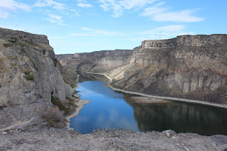
| Shoshone Falls, in the city of Twin Falls, looks more like a big rock ledge in the dry season. |
Twin Falls Park, one of the two areas the city was named for, included
a boat launch and picnic area. From here
the Snake River flows 681 miles to the Columbia River that takes its water to the
Pacific Ocean. But here so much water is used
for irrigation that water from September 1 through March 31 is only released over
the falls on weekends. Twin Falls just
dribbled.
“If there is no release here,
Shoshone Falls will be a greater disappointment,” moaned Andy, “and that one
charges admission.”
We passed fields of silage corn, rustling in yellowed dryness; and
fields of already harvested potatoes, the ground plowed and bare; and fields of
cut alfalfa, just stubble left as ground cover; and fields of harvested sugar
beers, green stems still evident. This
is definitely farm country.
The Shoshone Falls weren’t running. The collection booth was closed; they weren’t
charging, so we drove down.
 |
| From Twin Falls and Shoshone Falls, the Snake River carves its way through the canyon. |
Only a
little water came over the drop, but the sun did try to break through.
Gold was discovered below Shoshone Falls in 1869. During the summer of 1870, hundreds of prospectors entered the canyon searching the rocky slopes and sand bars for the very fine particles of gold called "flour gold."
Three mining camps--Shoshone, Springtown and Drytown--were established on the south riverbank between the present-day Mutaugh Bridge and the Shoshone Falls providing miners with supplies, dry goods and mining equipment. By 1871, when gold yields diminished, the miners sold their claims to the Chinese, who worked them until the early 1880's. But it paved the way for the development of agricultural communities. Hotels and businesses were already established to support the miners. Miners removed the precious metal from gravel deposits using pressurized water from a hose, like a firefighter uses. The gravel and gold were separated in sluice boxes. Gold here was difficult to extract, but it was worth the effort because of its high quality.
 |
| Stopping once more at the Perrine Bridge in Twin Falls, we photograph the Snake River one last time. |
There is no major mining activity in the area today.
We walked the canyon to each observation site
and then drove up to Dierkes Lake, the fishing area off the main river, a lake
formed by the dam. Seagulls and pigeons
rested on the dry rock tops where water cascades in other seasons. Some swooped up and down just in front of the
water that did drain in this dry season.
“It must be beautiful in the spring,” said Andy. We tried to guess how much of the cliff was
covered with cascades in wetter times or during releases. No matter, the
canyon, carved by the Snake, is beautiful.
At the Perrine Bridge, we once again parked and walked down and across
to the other side for morning pictures of the gorge. A cold wind whipped through the canyon. There was no doubt it roared down the river
gorge to foretell winter. We would not
loll at observation points here.
Goodbye, Twin Falls. We’re
headed toward sunshine. Ironically that’s due north.
Well outside of Twin Falls, a conveyor belt loaded potatoes into a
transport truck. Not much farther down
the road, a red-tailed hawk, with a morning catch in its beak, lit on a
telephone pole.
“I’ll bet that was a field mouse,” said Andy.
 |
| With heavy clouds overhead in front of us, we see snow high in the distant mountains. |
No doubt he was right.
“There’s snow on the mountains,” he observed, as we crossed into
Lincoln County. Ahead of us peaks rose high and white, but the sun was full on
the high plains.
As we got closer, it became more and more apparent that the mountains
had quite a lot of snow.
“That’s fresh snow,” said Andy.
“I think the weatherman said they had a chance on Monday or Tuesday
night but only in the mountains.”
“I agree,” I told him. “That
isn’t left from last year.”
We guessed the white probably covered the 10,000-foot elevations, since
the peaks ahead of us were more than 11,000 feet. Lava flows crossed the highway and lava
buttes dotted the landscape around us.
Cloud formations overhead painted pictures in the sky and cast shadows
on the plains beneath.
“That’s a different flow from Twin Falls,” said Andy about the sky.
 |
| Clouds dominate as we head north. |
“Those clouds are coming out of the west over the mountains. That’s s sign that the weather patterns are
changing.” Once again we saw evidence
that winter was coming.
Slopes to the south of the snow-capped peaks were dry and treeless, but
the ranches around Bellevue looked prosperous with huge homes and entry gates.
 |
| Snow blows into the valley from the north as we head up Trail Creek Road into the Sawtooth National Forest. |
The volcanic, the peaks didn’t hold the water. It probably soaks right down and drains into
the Salmon and Snake River Basins. The
slopes looked barren without even much grass cover. Those slopes, probably rising to 9,000 feet,
had no snow, but a biker we passed was bundled in scarf, gloves, ear muffs and
winter coat. It’s cold out there!
In Sun Valley, we hit our first little snow squall of the season, but
the road into the mountains was clear and dry.
 |
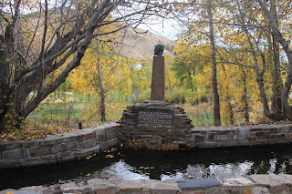
| Yellow aspen leaves float in front of the Hemingway statue. |
Trail Creek Road took us up into the mountains until the road turned to
a high gravel trail. Yellow aspens set the valley off in color. Peaks on either side topped 11,000 feet. Southeast-facing slopes dropped steeply with
clumps of grass covering the higher edges.
The northwestern side had Douglas firs.
We parked and watched the snow come down. Puddles in the campground pullout below us
suggested recent rain or heavier snow, but here it wasn’t sticking just yet.
Yellow aspen leaves fell with the flurries. Winter is coming in Sun Valley and Ketchum.
 |
| From the Hemingway Memorial the hills meet the running brook. |
“There’s the ski area,” said Andy, as we headed back down Trail Creek
Road across Antelope Creek. Ahead of us
was Bald Mountain and world famous Sun Valley Ski Area.
The Hemmingway Memorial, a simple roadside pullout included a
stone-lined brook and statue overlooking the golf course. The quote at the base of the statue were
Hemingway’s own words: “Best of all he
loved the fall with the tawny and grey, the leaves yellow on the cottonwoods,
leaves floating on the trout streams and above the hills the high blue windless
skies.”
The words had been penned in memory of his friend Gene Van Guilder, a
publicist for the Sun Valley Resort, who had been killed in a tragic
bird-hunting accident in Hagerman Valley.
I thought about Hemingway and the tragic loss. Leaves, yellow and gold, floated down on the
water and were carried away. And the
views in both directions were beautiful.
 |
| Aspen and cottonwood lend color to the dry slopes. |
Aspen and cottonwood trees quaked, as cold breezes ruffled the
remaining gold and yellow and pale green leaves. We stopped along Route #75 to capture the beauty. The trees set a striking contrast to the
fir-covered mountains. Blue sky showed
up just in time.
It was snowing at Chocolate Gulch on the Big Woods River.
“They’ve definitely had moisture here recently,” said Andy, as he
pulled into the Sawtooth National Forest Service Visitor Center. It was still snowing lightly.
 |
| Although most leaves are already down in the mountains, the touch of fall adds color to the steep slopes. |
Summer ends. A picnic table in
Sawtooth National Forest sat unused. It
will be a long time until spring.
 |
| At the Visitor Center in the Sawtooth National Forest, the days of outdoor picnics are a long way off. |
Across from our hotel, the Tyrolean Lodge, is a ski lift for Bald
Mountain. We didn’t know it before, but
this weekend is the 120th annual Trailing of the Sheep Festival,
October 5-9. Activities begin today with
the opening of Festival Headquarters and Cooking classes. Guess we’ll miss most of the fun, but Idaho
High Country is lovely.
No comments:
Post a Comment