RETIREMENT TRIP #7
Mountains of Clouds and Valleys of SunThe mountains all got snow last night. It was 39 degrees in Ketchum when we left town, but we were surprised to see all the surrounding peaks covered in white.
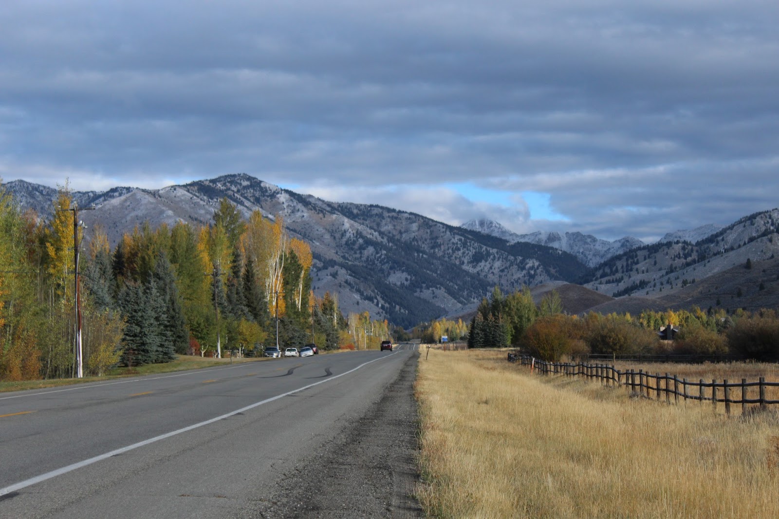 |
| Mountains along Route #75 are more than dusted with snow. |
Along Route #75, I hopped out for a few more pictures. “The clerk in the motel said the pass through
the Tetons was closed yesterday because they got dumped on,” I said. “She told me that when I checked us out.”
 |
| Even near the road, the snow has accumulated. |
“Once the sun comes out, this will melt,” said Andy.
I jumped out for more pictures.
“That may be, but in the meantime, it’s cold!” I touched his cheek with icy fingers. The next few shots I took from the moving
car.
“I can stop!” protested Andy.
“No need!” I said, warming my bare fingers. “I’ll put on gloves next time.”
 |
| Every bend in Route #75 brings new panoramas to life. |
“But I know why no one lives in Stanley,” said Andy. “The elevation is 6,260 feet, which makes it
one of the coldest towns in Idaho.”
 |
| Snow decorates everything in this magical world of Idaho high country. Boise reports 74 degrees. |
Galena Pass had no snow at all.
“That’s really odd,” said Andy, “because this road—Route #75—closes down
in the winter. It gets snowed under.”
“Not this time,” I observed, even though Galena Lodge was closed for
the season.
“I’m amazed and grateful,” said Andy.
“I guess Route #75 through Galena Pass closes intermittently during the
winter, but it’s the only road from Sun Valley to Stanley. Otherwise, we’d have to go all the way
around—probably 150 miles.”
 |
| Without explanation, some peaks collect more early snow than others. |
An overlook at the pass was dedicated to Bethine and Frank Church. He was a Senator from Idaho who worked
tirelessly to get the Sawtooth Mountains federally protected. Nature enthusiasts, he and his family camped
and rafted here at the mouth of the Salmon River.
I read the interpretive sign.
The country below me was tawny.
“The mountains to the west sucked up all the snow this time,” said
Andy.
 |
| Here in the valley at the base of the Church Overlook, the headwaters of the Salmon River originate. |
As the largest tributary of the Snake River, the Salmon River develops
from a small winding stream right at the base of the overlook where we
stood. It develops into an awesome river
that flows 425 miles through central Idaho and drains 14,000 square miles. It drops 7,000 feet from here and is also
called the River of No Return. That’s
because in 1805 its rough water and rugged canyons were impassible for the
Lewis and Clark Expedition.
This is the birthing place for Chinook salmon that return from the
Pacific after three or four years to spawn here. Chinook is the largest of the three Pacific
salmon species. Chinook and sockeye
salmon, which are now endangered, travel more than 900 miles to spawn here.
Through the pass, the headwaters of the Salmon River raced across the
meadows in a brush-lined stream. “I
don’t know how many Chinook can make it this far,” said Andy, “with the dams
and all.”
I got out near a turnoff for a historic ranger station to take pictures
of the water. What an unfathomable
instinct those fish have to return to their pints of origin!
We drove all the way back up to the top. This time we were actually IN the clouds, but
there was more blue sky and sun in the valley.
“That’s a good sign,” said Andy.
“It means the fog is lifting.”
I think that was just hopeful thinking!
 |
| The Salmon River, here just a fast-moving stream, rushes along at the base of the mountains where Vienna once stood. |
“It could just hang in the valley,” said Andy. “We’ll give it ten
minutes.”
A breeze would speed things up, but today was quiet. “It’s like watching water boil,” I told hm.
We gave up and headed back down to the valley.
At the Vienna pullout, a sign said this area had been the town of
Vienna in the late 1800’s. It became a
ghost town in 1900, but at that time there were more than 200 buildings here,
including four hotels and a $200,000 twenty-stamp mill to crush gold ore. Now there is nothing except a couple houses
and the Smiley Creek Lodge, a mile down the road.
It all started in 1878, when Lei Smiley discovered gold on Smiley
Creek. A year or so later on June 4,
1879, E.M. Wilson found a richer lode eight miles away. And the rush was on!
We turned into a side road at Alturas Lake and followed it past
organized summer camps and Forest Service Campgrounds for four or five miles
until it turned to gravel. Snow flurries
fell like raindrops on the water of Alturas Lake. We could even hear the flakes hit the car,
but none accumulated on the ground. It
was a sign of things to come.
I looked for black bear or moose or even deer, but all was quiet and
the campgrounds were all gated.
 |
| At Redfish Lake we suspect a bear has been visiting. |
Back along the main road, it was readily apparent where the Salmon River
flowed. Rust, yellow and gold bushes
lined both sides of the river bed. Green
in the summer due to the presence of a year-round supply of water, all the
bushes displayed brilliant autumn colors against the dull grey sage and dry
grass.
Near Cold Creek a herd of pronghorn antelope grazed peacefully. The male kept close watch when we stopped,
but the females in his harem were more intent on eating.
So far the closest we’ve come to a bear is a cage at Redfish Lake tent
campground that looked very much like a bear cage.
Redfish Lake Lodge in Redfish Lake is a beautiful rustic resort. A few bundled people walked along the beach
and boat dock, and a motor boat zoomed in from the center of the lake, but most
visitors scrunched their shoulders in chill.
From the Sawtooth Ranger Station one of the jagged peaks poked
through. I grabbed the camera, but the
white was too much. It was hard to
decipher peak from clouds.
 |
| Nestled in the mountains, Stanley is remote but beautiful. |
Ten miles away Sunbeam Hot Springs by the Challis National Forest had a
bath house that was built by the Civilian Conservation Corps during the
Depression in the 1930’s.
“The river is really flowing here,” said Andy, “and it’s the dry
season. It looks like it goes up eight
feet in the spring.”
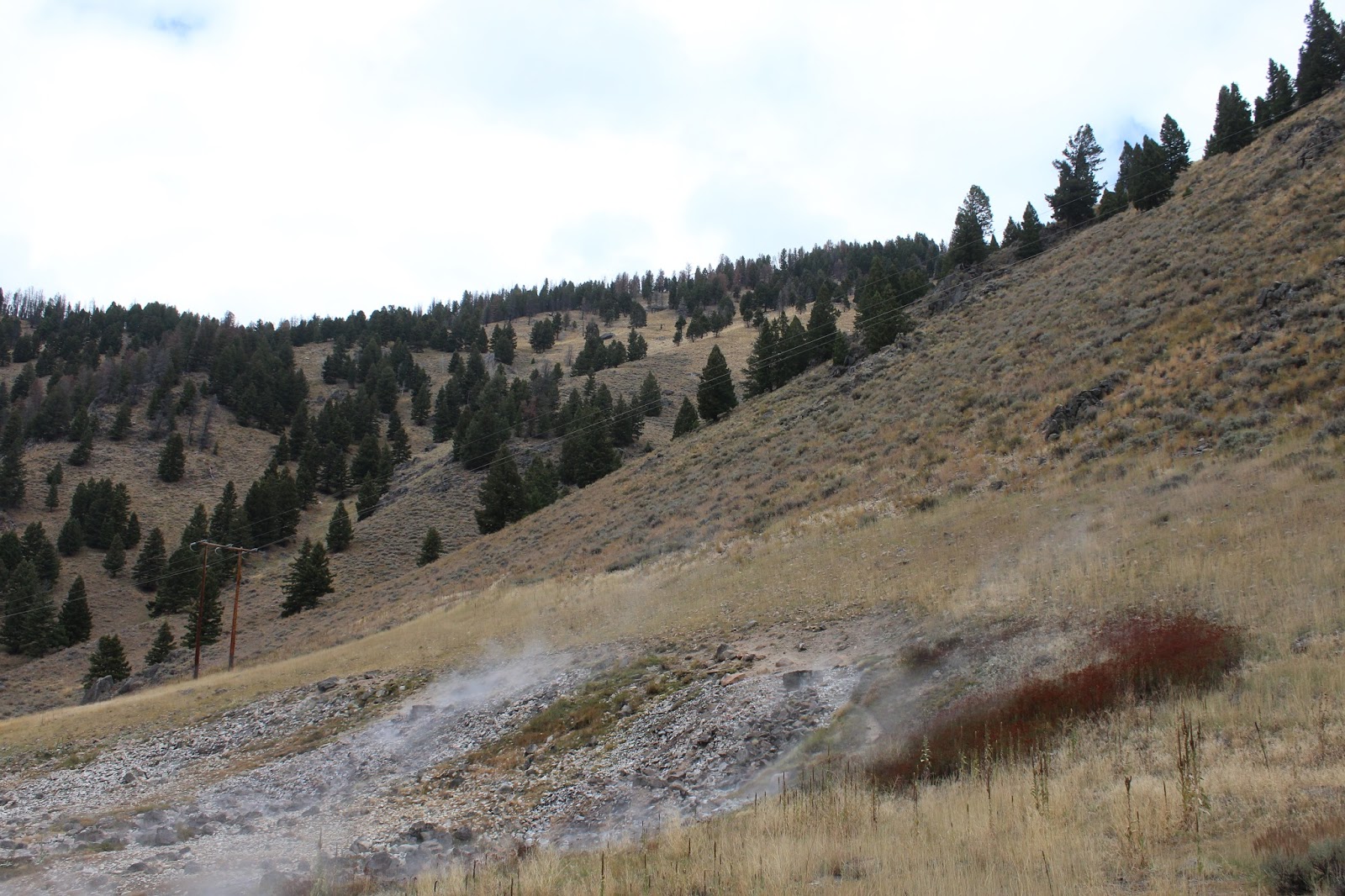 |
| In the Challis National Forest, the Sunbeam Hot Springs puff away from the side of the gravel embankment. |
The bath house was a tourist stop for a natural hot spring across the
road. Completed in 1937, it fell into
disrepair due to lack of maintenance funds and personnel during the War. Hot water was uniquely diverted from the hot
spring through a pipe to the Salmon River.
The cold river cooled the hot water in the pipe and ingenuously sent it
back to the bath house.
Here a cabin in the early 1900’s was heated by hot spring water piped
into barrels under the floor.
Barzilla Clark, caretaker of the Sunbeam Dam, tried to raise chickens
here. He failed at that, but later he
became mayor of Idaho Falls and Governor of Idaho.
In 1870, the first prospectors filed claims at the junction of Jordan
Creek and Yankee Fork River. Several
boom periods followed until the rush permanently ended in 1910.
It was nine miles into the ghost town that Andy had chosen as his final
Thursday destination. We set out
climbing into the mountains in a steep incline.
But about four miles in, the road turned to wet-pack mud. Signs suggested work was being done to
improve conditions for fish, and dredging had been done on both sides to create
ponds. But our clean little Ford Fiesta
wasn’t going five more miles on slippery dirt.
It might have been okay if it had not snowed. We turned around.
 |
| The remains of the dam from days long gone by still block part of the Salmon River. |
At the turnoff for Sunbeam was an information overview of the Salmon
River. We stopped to eat our apples,
read the history and take pictures of the dam.
Built to provide power to the mines and the community of Sunbeam, it was
breached to allow for fish migration up the Salmon River. It was the only dam ever built on the Salmon.
 |
| Clouds lift somewhat as we enter Lower Stanley. |
Towns like Bonanza and Custer sprang up with large mills like General
Custer, Charles Dickens, Lucky Boy and Sunbeam, built to process rich ore.
Gold dredging was active from 1940 to 1952, when as estimated 1.8
million was mined here.
A little farther down, before the road was closed for repairs, we
stopped to read about “coyotting” on the Salmon. A sign explained the dangerous mining
technique, but apparently the lust for wealth drove some to extremes.
For two million years the Salmon River changed course, leaving older
channels high and dry. Gold, eroded from
surrounding mountains was often deposited in these gravels of ancient river
beds.
Near this bank in the river, German-born Herman Centaurus used the
risky method of “drift” mining or “coyoting.”
He dug into old river gravels, located a rich paystreak running parallel
to the river, and then drove a shaft or “drift” along the paystreak. It was dangerous because of the frequent
cave-ins. Many miners died in the
process.
 |
| Back in Stanley we take advantage of breaks in the clouds to photograph the spectacular surroundings. |
Heading back through Lower Stanley, the clouds cleared some of the
higher Sawtooth peaks to give us glimpses of the snow-capped ruggedness.
“It’s too bad the blue sky is off to one side and not right behind the
mountains,” mused Andy.
But we still had had a taste of this wild Idaho world. And it was magnificent.
 |
| Sun highlights the snow-capped mountain peaks in Stanley. |
When the sun popped out for a minute on the peaks and a patch of blue showed
up, we looked for a high point in Stanley to shoot the mountains. Who would have thought the dead end side
street would have old wagons and even a Conestoga.
We headed back to Redfish.
“There’s an archaeological highlight there,” said Andy. “It’s on my 30-year old map, so we may not find
it.”
 |
| Andy checks out the vandalism notice at an archeological site outside of Stanley. Ancient people lived here. |
At the first pullout, a sign marked the bridge over the Redfish Lake
Creek. There was an unmarked trail on
the other side of a clearing. The trail
led to a large granite outcropping, but it was taped off.
“Closed due to vandalism. Fine
of $5,000, per individual, and not more than $10,000 for coming within ten feet
of cave.”
We couldn’t see any vandalism, but there was evidence of fire
nearby. Sadly, vandalism had apparently
damaged an ancient relic. The Redfish
Lake Creek Rock Shelter had been home to ancient peoples. Artifacts that dated back 10,000 years had
been found there.
 |
| In the late afternoon sun under the shadow of snow-capped peaks, Redfish Lake sparkles. |
We drove back in to Redfish Lake Lodge.
The sun was out, and the crystal clear water of the lake sparkled in the
afternoon brilliance.
Stanley was our home for the night.
This place was Paradise! But I
wouldn’t want to live here.
No comments:
Post a Comment