Pages

Tuesday, September 13, 2016

RETIREMENT TRIP #7
Hood River Valley Exploration
                                                                           On the road by 8 a.m., we passed the wind farm again.  The windmills were all gracefully spinning in the early morning breeze.
“Maybe we could put one in our yard,” I mused out loud.  “They are so pretty to look at and we could even generate electricity and save money.”
Andy scowled.  “They kill lots of birds,” he countered.  “I guess birds try to land on them—big birds—birds of prey like hawks and eagles and falcons.  They must misjudge the power of the blades.”
“Woodpeckers!” I exclaimed.  “We could put up a windmill and get the woodpeckers!”  All summer we had battled woodpeckers on the hummingbird feeders.  “Could you call that killing two birds with one windmill?”
He didn’t think I was funny.
Wide and beautiful, the Columbia from Rowena Crest,
looks more like a huge lake.
In The Dalles, Andy put me in charge of finding the Rowena Loops, a narrow winding road along the Columbia.  “Me” in charge is never a good thing when it comes to navigation, because Andy rarely tells me precisely where we are in the first place, but this time success was mine.
A couple turns and we were following the mighty Columbia along a narrow road through the country at the base of the Gorge to the Rowena Crest Viewpoint. 
Spectacular, rugged country
spreads in every direction
from Rowena Crest.
Wind whipped across the plateau at Rowena Loops. We walked around the circle for views of the river far below and the famous Rowena Loops Road that circled the canyon wall to the top of the plateau.  A cold wind made it hard to steady the camera, but the scenes were magnificent.
The graceful S-curve of Rowena Loops almost doubles
back on itself.
From the viewpoint we could see Mount Adams in the distance.  “Mount Adams is a thousand feet higher than Mount Hood,” said Andy.  “This is our third visit here.  We came in 1978 with the kids.  Tara was just a baby.  And we came once when we flew to Portland, but I don’t think we ever drove this stretch.”
Cataclysmic floods during the twilight of the Ice Age affected the landscape, creating scablands called the Rowena Plateau.  The massive ice sheet that covered Canada dammed rivers up to 2,000 feet thick with glacial ice.  The largest of these held more than 500 cubic miles of water.  Rising waters undermined the ice dams, causing huge floods to sweep down the Columbia, scouring the land as many as 100 times and creating the formations of today.
Away from the ridge,
the country side offers peace.
The graceful, winding historic Columbia River Highway was one of the first modern thoroughfares in the Pacific Northwest.  Engineer John A. Elliott determined that the eastern section should be built in concert with the gentle turns of the western end.  So he echoed the loops with sweeping S-turns here along the cliff face.  Hence, the Rowena Loops.
At Memaloose Overlook we read about the ancient Indian practice of leaving their dead in a canoe on an island in the middle of the Columbia River.  The bodies were wrapped in robes or tule mats.  Memaloose is derived from the Chinook word “memalust,” which means “to die.”  Lewis and Clark named the island Sepulcher Island and visited it in 1806.
Far below and to the right is all that
remains of Memaloose Island.
The singular monument marks
the grave of pioneer Victor Trevitt.
The lone monument visible today marks the grave of Victor Trevitt, a pioneer, printer, businessman, state legislator and friend to the Indians.  He requested burial here among the people he loved.  The building of Bonneville Dam prompted relocation of the Indian graves in the 1930’s, and ironically only Trevitt’s grave remains. 
From the top of the Memaloose Viewpoint, we see Mount
Hood.  Mount Adams was also visible.
What a spectacular view we had of the only remaining island since the dam was constructed.  And all but about a third of Memaloose Island was under water now. 
In the other direction we could see wind surfers sweeping back and forth across the Columbia, their fluorescent green sails twisting and turning in the wind.  The gusts must have been 50 m.p.h., since I couldn’t hold the camera steady.  “Down there, they’re lovin’ it!” said Andy.  White caps dotted the whole river from shore to shore.
With careful map reading we found Panorama Point in the Panorama Point County Park.  The guidebook said this stop offered “the best views of the Hood River Valley, stretching from Mount Hood to the Columbia River Gorge.”  The view features more than 15,000 acres of orchards and vineyards.  A tower at the viewpoint actually decorates one of the stations of the power lines that stretch from a dam on the Columbia.  It was a clever way to lend beauty to something detracting and ugly on the landscape.
Bradford Island Visitor Center at Bonneville Dam was a couple miles in from the main road and a security check of the car by an armed guard.
We watched the salmon and sturgeon navigate the fish ladders from outside above the water and inside beneath the water.  What a fascinating display of power and determination!
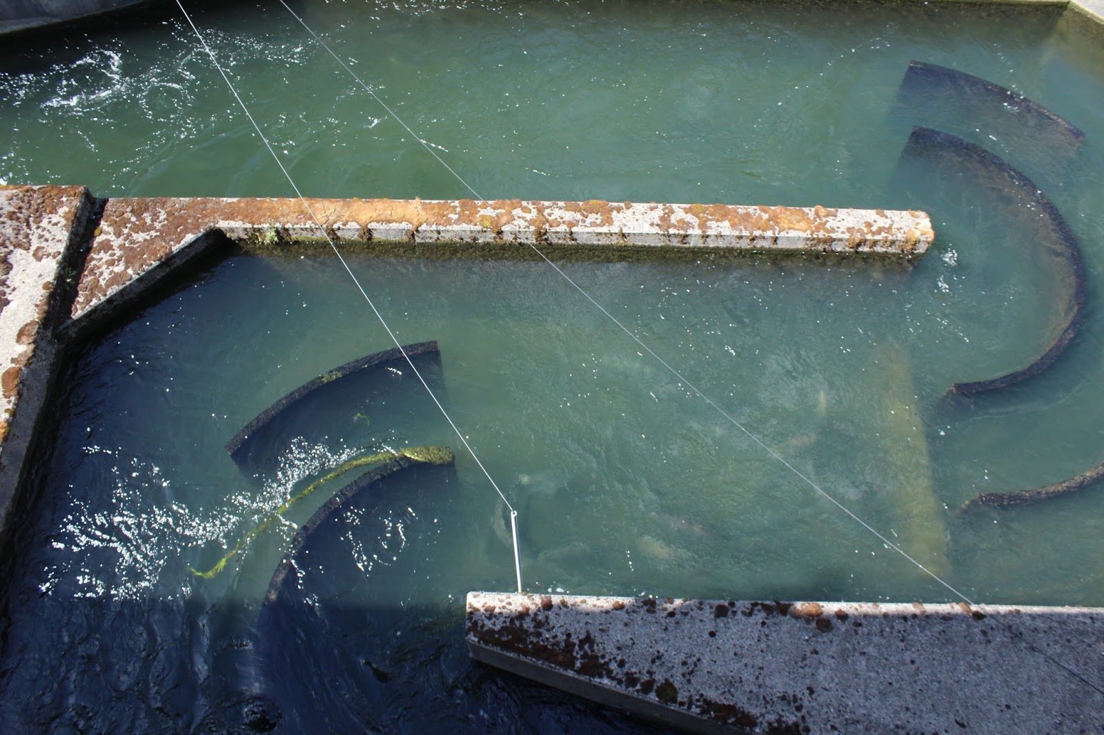
Visible under the water,
salmon climb the fish ladders.
At Bonneville the fish ladders were built when the dam was constructed in the 1930’s.  Slots at the face of the dam guide fish to the four fish ladders that lead to a fish collection channel so they can continue to swim upstream.
“Lots of injured ones come through,” said one guide, “because of all the sea lions below the dam.”
We didn’t see any sea lions.
Salmon and sturgeon climb the fish ladders in
full view of the public at Bonneville Dam.
It takes an average salmon 36-38 hours to go through all the steps in the ladder.  “The steps are about a foot each,” said the guide, “and there are spots to rest for the fish.  But they have to go up a total of 60 feet.  Some can make it in as little as two hours; others can take as long as 48 hours.”  The whole process was fascinating.
Inside the Visitor Center I read all kinds of interesting facts about the dam.  Studies have shown that fish now swim past the dam just as successfully as they swim through comparable undammed rivers.
The dam has a spillway, like all dams, for when flow is excessive.  With the spillway open wide, the water flow is 12,000,000 gallons per second.
Construction of Bonneville by the Army Corps of Engineers began in 1933, and the lock and dam was dedicated by President Franklin D. Roosevelt on September 28, 1937.  Then the total construction cost was $88.4 million. 
Bonneville Lock and Dam is named for Army Captain Benjamin Bonneville, an early day visionary who led an exploration to the Oregon Country and charted extensive sections of what became the Oregon Trail.

Bonneville, the first of four dams on the Columbia,
generates power for thousands.
Lake Bonneville, the 48-mile long reservoir impounded by the dam, is the first in a series of navigable lakes which are part of the Columbia-Snake Inland Waterway, a water highway running 465 miles from the Pacific Ocean to Lewiston, Idaho.

Sometimes in the spring when water is high and winds are blowing, the Northwest United States runs almost entirely on renewable power.  No wonder our rates out East are so high!
Hydroelectric dams provide the nation’s largest source of renewable energy perpetually fueled by nature.  The four dams on the Columbia—Bonneville, The Dalles, John Day, McNary—produce as much energy as 20 coal-fired power plants but without the pollution or greenhouse gases.

Wahclella Falls tumbles in
majesty over the cliff face
even in the dry season.
The next stop was the Locks.  We read that the newest lock took 38 million gallons to fill—enough water to take a bath every hour for 110 years.  All boats can use the lock system, and the new one can hold a tug and five barges at once.  Mostly wheat, gasoline, fertilizer and lumber products travel through the locks on a regular basis.
At Horsetail Falls we trade picture-
taking with another couple.
Our next stop was the Columbia River Gorge.  The trail to Wahclella Falls was a two-mile, semi-loop up some steep terrain.  Lots and lots of people climbed the narrow, rocky path to view the first falls down a step flat rock face and the second falls, a series of three separate drops over the cliff head into a narrow ravine.  Moss coated the tree trunks and dripped from the branches.
Horsetail Falls was a crazy house of people.
“I just can’t believe how much water is coming down in the driest time of year,” said Andy.  We hopped out for pictures, but Andy never was one for staying where people congregated.
Temperatures cooled off after 3:30 p.m. as we neared Wahkeena.  Wahkeena Falls was only a quarter-mile in uphill to the bridge.  The path was steep but paved with asphalt.  It would have been a refreshing place to stop and sit, if it weren’t for the spray and all the people.
Crossing the small bridge
below Wahkeena Falls,
we are doused with spray.

My immediate concern was about protecting the camera.  Lush vegetation lined both sides of the trail.  “It’s a Pacific Maritime climate,” said Andy, “dry in the summer and rainy all winter.  The growth is temperate rainforest.  It doesn’t get super cold for long stretches.  I read,” he continued, “that every mile you travel inland from Portland, the land gets drier and the amount of rain goes down.”
A bright yellow lichen
paints the wall next to
Latourell Falls.
Latourell Falls dropped in a single stream from the top of the cliff.  Bright yellow lichens painted the adjoining cliff face.  We probably walked a mile before deciding the actual trail wasn’t a loop and we’d have to retrace our steps to the car.  Later in the parking lot a gentleman told us the trail actually did loop back in a 2.8-mile circle.  It was already 4:30 p.m. when we got back to the car.  “We’ll have time to come back tomorrow if we get up early,” said Andy.  But he wasn’t done for today yet.
The view from Larch Mountain summit spans the world!
But temperatures plummet by late afternoon.
Andy had one final plan for September 11th—the 14-mile drive up Larch Mountain.  The road wound crazily through thick woods and past sections that had been clear-cut logged in and away from the road.  The sun hardly penetrated the stately pines, so only occasionally was the cutting noticeable. 
We parked at the summit lot and hiked the .3-mile Sherrard’s Point Trail up about 50 stairs to the peak.   What a view!  Mount Jefferson, 62 miles away, stood out clearly in the distance; the other peaks were hidden in clouds.  Mount Rainier, 97 miles, was barely visible; the top of Mount Hood, 22 miles, peaked through now and then, and Mount Adams, 46 miles, was encircled in clouds.  We visited with a local couple who were entertaining friends from Virginia.  By the time we started down, the temperatures had dropped into the low 50’s or maybe even high 40’s.  It was cold at 4,056 feet, and it was time to go home!

Sunday, September 11, 2016

RETIREMENT TRIP #7
Along the Mighty Columbia
                                                                     The view from the patio outside our room at Mountain View Motel and RV Park in Joseph, Oregon, was breath-taking at 6:30 a.m.  Mountains, the Wallowa, rose majestically with remnants of last winter’s snow, and horses grazed peacefully in an adjoining field.  I thought of the Nez Perce and their beautiful land.  No wonder they were willing to fight to protect its sanctity.  I thought of Old Chief Joseph too who said, “I believe much trouble would be saved if we opened our hearts more.”
Oregon State Parks are open to the public and usually free.
We followed the Wallowa River west along route #82 toward La Grande.  “It’s already hunting season,” said Andy, when we saw an orange and yellow-vested man cross the road and disappear into a pine grove.  Several pullouts highlighted Oregon scenic wonders, and State Parks offered recreational outlets.  We stopped for photographs and took in the glorious mountain vistas.
A huge plateau of rich farmland opened up as we went up in elevation.  Ranches with fields of wheat, barley and hay spread in every direction outside the little western-looking town of Elgin on the La Ronde Grande River.  Here, the planting seemed more scientific with contoured fields and even signs that suggested removal of invasives.  “Is this Spanish or French?” asked Andy.
“No accent on the ‘e’ would suggest French,” I told him.
Beautiful Historic Arch Bridge
seems like someone's payoff!
“And the Spanish didn’t come this far north,” he added.  “It was French trappers here so many years ago.”
The “Historic Arch Bridge” protected a bridge on the old highway,.  We exited Route #84 to check out the sight. 
“Somebody got paid off for that one!” I joked. 

Everywhere windmills reach skyward, churning and
turning to produce electricity.
Andy agreed. Since the turnout followed the old highway a couple miles in and the arched bridge to absolutely nowhere had been totally repaired with a viewing park created nearby.Outside of Meacham, we saw evidence of logging at the 4,193-foot elevation.  “That’s about as high as the Catskills in New York,” said Andy, “and they must get a lot of snow here from the looks of the trees.”  All along the road we saw chain-up signs, and Andy said he had read that the highway we had taken yesterday out of Hells Canyon was open only for skiers and snow mobile riders from October 30 through May 30.
The mighty Columbia River carries people and good deep
into the interior of the country.
Pendleton was one huge traffic jam because of the Round-up Rodeo and parade. We left as quickly as we could, which anything but quickly!  On the other side of the city the rolling yellow grass hills stretched without a tree to the horizon as far as the eye could see.
Outside of Boardman, Route #84 met the Columbia River.  Huge and wide and blue, the mighty Columbia looked more like a lake.  The brown, dry hills formed an incredible contrast to the blue water.  Across the highway, a wind farm of windmills churned away.  What clean and powerful and cost effective sources of hydro and wind energy for electricity!

Taking pictures is a "snap," now that we've figured
out how to use the timer on the camera! 
We didn’t anticipate heading to Biggs with views of Mount Hood and crossing the Columbia River into the state of Washington, but a mix-up in motel reservations in Joseph inspired a quick change in plans.  Happily that meant a visit to Maryhill Winery and a bottle of Riesling, while a live band played cool jazz.  Oldsters with a huge assortment of dogs on leashes filled the patio that overlooked an outdoor concert courtyard.  Mount Hood rose majestically in the distance, still dominating the landscape some 30 miles away with snow-covered slopes. We chose our bottle of Riesling and sat on the deck, enjoying the music.  Then we headed to Maryhill to stroll around the grounds and sculpture gardens.
An almost-exact replica of the original, Stonehenge honors
those from Klinkitat County who died in World War I.
Our next stop, Stonehenge, honored and remembered the deceased veterans of World War I from Klinkitat County, Washington.  Plaques to each with birth and death dates (1915-1918) lined the inner columns.  Nearby citizens had erected a World War II, Korean, Vietnam, and Afghanistan War Memorial.
A hot breeze swept across the hills, reminding us that summer wasn’t gone yet.
Here Stonehenge is a memorial
more than a cultural symbol.
 Hundreds of stately white wind turbines graced the scree slopes surrounding the John Day Dam on the Columbia River.  The white of the windmills and the concrete dam and the deep blue of the river lent a vivid contrast to the yellow-brown hills and black lava outcroppings.
From the Washington side, the John
Day Dam spans the Columbia.
We drove back to Broadman along the Washington side of the Columbia, admiring the thousands of wind turbines whirling away on both sides of the mighty water.  We passed acre upon acre of grape vines and peach orchards that accented the yellow grass terrain.  The Oregon side was too rocky and steep to sustain such farming.  But here in Washington the fruit industry thrived.

Saturday, September 10, 2016

RETIREMENT TRIP #7
Heading into Hell--the Canyon, That Is!
                                                     When we got up this morning, the house across from the motel had between draped with toilet paper. It brought back fond high school memories. The waitress at breakfast explained that by tradition the competitive volleyball and football teams dress each other’s homes on game nights, but local police don’t mind as long as they kids clean up the mess.  Andy told her about my choice encounter with the whole practice senior year. 
Lush dry grass covers the hillsides of
western Idaho.
From Cambridge, we headed due north into Wallowa County.
"The mountains are getting bigger,” said Andy, as we crossed over a 4,128-foot rise and saw the peaks ahead of us.  We were headed toward Hells Canyon between Idaho and Oregon.
The lake formed by the damming of the Snake River glistened in the early morning sun.  We stopped twice for pictures, but taking them was tricky business with the difference of lighting and my shadow.
The road wound in sharp curves around the lake up to the Brownlee Dam.  Andy thought he saw a ferret dash across the road.  I missed it.
In 1862, John Brownlee settled in the area, and a creek was named after him.  In the late 1800’s Brownlee started a ferry service to shuttle silver miners and their ore across the Snake River.  It operated until the late 1800's.  Miners were still active in 1960, when ore was moved in huge trucks.  Other methods like rail and tram were tried, but the steep volcanic slopes made transportation difficult and expensive.
Dammed for hydro power, the Snake River spreads wide
in the harsh landscape.

Still in Idaho, we photographed the dam and spillway.  “There are still disagreements here,” said Andy.  “The two dams impinge on salmon migration up the Snake River.”    It was easy to see why from the height of the spillway. Just then we saw a fish jump for a bug in the river next to us.
Brownlee Reservoir is 58 miles long, the longest on the Snake River, and it stores 1,500,000 acre-feet of water of which 1,000,000 acre-feet are available for power generation.  The capacity of the dam is 585,400 kilowatts of electricity.  Brownlee produces more electricity than any of Idaho Power’s other hydroelectric plants.

From the Oregon side of the Snake River, we record
spectacular views of the canyon.
An old barbed wire fence
marks a ranch boundary.
Once on the Oregon side we stopped again for pictures and walked into a side canyon.  “That’s probably somebody’s ranch,” said Andy, looking up the rock slope.  Brown-eyed Susan's and bluebells bloomed everywhere.  Craggy volcanic rock columns jutted out from beneath the dry grasses in Devil’s Postpile formations.At Oxbow Dam in Oregon, we walked into some Devil’s Postpile formations accented with bushy purple flowers that reminded me of lilacs. We learned later that they were actually blue-colored berries in bunches on a tree.  From a distance we could see the dam and the lake it created.  Vegetation along the water grew lush and green in contrast to adjoining dry, grassy mountainsides.
“There is one area here that is actually deeper than the Grand Canyon,” said Andy, “but you’re on the bottom instead of the top. It’s the deepest canyon in North America.  It’s cut by the river, but it’s off the beaten path.”

The private power company road allows tourists to
explore along the Idaho side of the river.
Oxbow got its name from a three-mile bend in the Snake River.  To early settlers in the area the river bend looked like the U-shaped frame that forms a collar about an ox’s neck.  The site is 13 miles below Brownlee Dam.  Here the river carves its way around a large mass of erosion-resistant rock.  It’s one of the world’s most unusual dam sites.  Oxbow, on average produces 1,104,144 megawatt hours of electricity per year, enough to supply approximately 76,000 households.
We took the 17-mile private power company road on the Idaho Side to the third dam, Hells Canyon Dam.
Andy "bears" the journey along the power company road
a few miles from the Hells Canyon Dam.
“They let cattle graze in here,” said Andy, when we saw some from the Oregon side as we drove toward Hells Canyon Dam.  “They probably stay in here all summer.”  Just then a cowboy rode into view.  We watched him follow one black heifer along the path for what must have been a quarter mile.  A small group of cows stayed behind on the steep slope, grazing peacefully.  Suddenly I spotted another cowboy on horseback coming from the opposite direction and driving a collection of six or eight more cows.  “They are rounding up the cattle for winter,” said Andy.  “The government probably sells them grazing rights.   The power company maintains the road and campgrounds, but it’s Payette National Forest, so the government manages the land.”
On horseback, a cowboy rounds up
his cattle and drives them out of
the canyon to winter quarters.

The canyon narrowed and deepened the farther in that we drove.  No longer was there a cow path on the other side, and the mountainside dropped steeply to the river.  At Lynch Creek we could trace the creek bed as it dropped down the cliff.  It is just a line of green in the dry summer sun of September.
Green swatches down
canyon walls mark
the stream beds.
At Black Point a sign explained the historical significance of the area to the mining industry.  Another trail of green marked the dry stream across the river.
We crossed the Hells Canyon Dam back to Oregon and had our first glimpse of the unadulterated Snake, with whitewater rapids accenting the flow even in the driest month.
At trail’s end, Hells Canyon Creek, the Visitor Center, showed a movie called InFocus about cooperation to preserve the land and provide recreational facilities for the public, 652,000 acres of unspoiled wilderness—fishing, hunting, riding, camping, hiking, cross-country skiing, boating, rafting, appreciating the natural world.
From the Visitor Center whitewater rapids
are visible even in the dry season.

Historians say the name Hells Canyon had its beginnings with a cargo ship pilot named Haller.  The story is that Mr. Haller built a boat named Norma to haul copper ore from mines located near present day Oxbow.  In the Norma’s first and only trip through Hells Canyon in 1895, Haller found the river rapids more than he had expected.
Either because of what Haller said as he tried to pilot the boat or because of inaccurate repetition of his name in the phrase “Haller’s Canyon,” the name Hells Canyon stuck.
The wildness of the river and the nearly impassable, steep mountain terrain probably had a lot to do with the naming of the canyon too.
Hells Canyon is the deepest canyon on the North American continent, and the site of the Hell’ Canyon Dam is one of the narrowest points in the canyon.  Before crews could begin construction at the site an access highway 23 miles in length had to be cut along the Idaho side of the canyon.
Morrison-Knudsen, the contractor, used a small strip of level ground two miles upstream to erect trailer-type offices, a first-aid facility, machine and carpenter shops.  Nine miles upstream living quarters and a mess hall were built.
Andy climbs high up
the canyon wall.
Because of the closeness of the canyon, there was no room for a switchyard, so it was erected on the downstream face of the dam.  Helicopters were used to move tools and equipment into place and to erect transmission towers.
These towers hold transmission lines in place that carry power out of the canyon on the Oregon side.  Despite the cramped working space, the concrete Hells Canyon Dam was built to full height in only 16 months.
The total project investment was $278,000,000 for the development of Hells Canyon, including the construction of Brownlee, Oxbow and Hells Canyon dams.
The ranger, an environmental science major, identified the unusual plant we had seen as mullein, an invasive from Eurasia that moves into disturbed land.

Miles away at Canyon Overlook, Sue celebrates a birthday.
We watched some rafters cleaning gear, climbed part way up the basalt cliff for the view, checked out the Visitor Center displays and relaxed long enough to breathe deeply and enjoy the weather—brilliant sun and low 70-degree temperatures.  This was HEAVEN, not Hell.At the turn out of Hells Canyon National Recreation Area we saw a “grouse barrel.”  Probably ordinary for Idaho natives, we found the instructions to clip wing and tail of each bird an unusual and interesting practice.

Seven far distant peaks are the Seven Devils that helped
give Hells Canyon its name.
From there, the Hells Canyon Overlook was 23 miles, road closed after October 15th for the winter.  Guess that speaks to the severity of the weather in this remote country.  Mullein thrived along the roadside however.
The road wound high up to Hells Canyon Overlook in the alpine and subalpine climatic zones.  Open meadows, blanketed with the orange and brown remnants of spring wild flowers, dotted the mountainside peaks in between stands of pine.  In the distance we picked out the Seven Devils, Mountains that contributed to the naming of Hells Canyon.
“We’re going up again,” said Andy, as we got closer to Joseph, Oregon.  The Wallowa National Forest harbored huge, old pine trees.  Suddenly there was a lumber truck ahead of us, but we hadn’t seen any evidence of cutting.
An unobtrusive grave
commemorates
Old Chief Joseph.

Bronze statues line street corners
in downtown Joseph, Oregon
After checking the motel location in Joseph, Oregon, we leisurely drove through the park at Wallowa Lake, a six-mile long playground for water skiers, jet skiers and paddle boaters.  Andy rejected thoughts of riding the tram to the viewpoint when we checked the price: $38 per person (only $28 for Seniors over 65) to go up and down. I more than agreed with his choice of activities. Instead we climbed a small rise to the gravesite of Old Chief Joseph, the Indian father who refused to cede all the Nez Perce land to the federal government. 
The evening in Joseph, Oregon offered a special birthday treat: bronze sculptures on almost every street corner and art in classy shops along the six or eight blocks of manicured brick walkways.  We spent a relaxing evening browsing, picking up a few necessities at the local market, having Mexican dinner and deep fried ice cream at La Laguna and then walking the 1.25 mile path through Iwetemlaykin State Heritage Site, a 62-acre park dedicated to the Nez Perce Indians and Old Chief Joseph.
Before checking in for the night, we watched darkness settle in along the beach and boat dock at Wallowa Lake and strolled out over the water on the floating pier--a picture perfect celebration of life!

Friday, September 9, 2016

RETIREMENT TRIP #7
Heading West Again
                                                                              Here we go again! We're on the road again...Willie Nelson couldn't have sung it any better!
The thought reverberated in my mind and haunted my brain yesterday, as we prepared for retirement Trip #7:  packing, watering plants, changing beds, writing checks, closing windows.
But at 3:00 a.m. when Andy's radio alarm jolted us awake and my phone alarm urged us out of bed, we weren't singing much.
We encounter the local inhabitants
in Weiser, Idaho.
Uneventful flights took us from White Plains, New York, to Chicago O'Hare to Boise, Idaho. But we almost didn't make it.  We had plenty of time in White Plains for our 6:34 a.m. departure and the plane rested at the airport overnight, but United delays of 70 minutes devastated our connection.  Luckily a combination of unsettled weather around O'Hare, kind pilots who held the next flight and a run of only about ten gates got us on the plane as the door closed.
So now we head out on another adventure in a little black Ford Fiesta through Big Sky country.  Little Red sleeps in the garage at home, and we're on the road... again.
In Weiser, Idaho, we spotted some of the local wildlife.  I guess he's been here for quite some time. In no hurry today, we gave him time to pose for us. 
In spite of the dryness, the river and roadway
cuts through picturesque hillsides.
Around Boise and along Route #84 West, the country rolled in dry brown waves.  Here and there fields of dried out corn stalks rustled and nodded in a stiff breeze.
As we headed north along Route #95 toward Cambridge, the hills greened.  Peaks rose in the distance.  "That's where we go tomorrow," explained Andy.
"A few years ago I read that Idaho had more millionaires per capita than any other state," said Andy, as we drove through the countryside around Cambridge, a town of 360 people.  Ranches dotted the rolling hillsides--mostly brown grasslands dotted with sage and small trees.
An old steam-driven contraption
decorates the park in Council.
But homes, not ostentatious, looked as though people made a decent living here.

An old steam road paver or tractor of some kind decorated the village green in Council, Idaho.
We cruised through the Payette National Forest, amazed at how dramatically the land changed as we went up a few thousand feet in elevation.  Outside of New Meadows, a lumber yard puffed away. 
Piles of cut boards line the roadway
for several blocks near the lumberyard.
Huge piles of cut boards lined the road on one side; raw logs sprayed with streams of water were stacked haphazardly on the other.
Piles of logs are kept moist and fresh
at the lumber yard with sprays of water.
We turned around in New Meadows, a town of about 533 people in the center of Idaho's Heartland.  The lumber yard was still puffing and spraying away as we headed back, and the smell of sawdust and freshly cut timber filled the air.
At Office Bar in Cambridge we ordered smoked ribs for dinner.  Max, a large black lab, met us at the door and never left our sides. 
Max tries to convince Andy that he really wants the dollar,
not all the petting, at the Office Bar in Cambridge.
He took up his station between us at the table, and then he put his head alternately in our laps the whole time we ate.  "He's trained to do that," explained the bar tender. "He's waiting for a $1.00 tip to bring to the bar."
As strangers in town, we undoubtedly attracted Max's attention.  All the locals at the bar ignored him.  Faithful to his post and duty, he only left when border collie Jack took up the position.

Sunday, August 14, 2016

NEW YORK STATE SIGHTS--
WonderWorks, Forestburgh, Bashakill         


                         Andy maneuvers the controls
of a spaceship as he tries to land the craft.
"I never in a million years would have imagined I would see so much of New York State!" marveled Andy recently, as we headed back to Tara's house. "The city, maybe, but we have been all over this state and seen ever so much more than the average New Yorker!"
He was absolutely right.
After four State Conventions for FFA to Medina, Albion, Morrisville and Syracuse that lasted five days each and weeks and weeks of animal sitting at Tara's house, we have covered many interesting spots in the state.
Two visits to WonderWorks, Destiny U.S.A. in Syracuse were connected to FFA travels. Both times we chaperoned large groups of teenagers, but there was plenty of time to test out the scientific theories and try our hand at manipulating experiments.
Andy landed the shuttle, or at least he tried.  In November of 1983, the Space Shuttle Discovery was delivered to the Kennedy Space Center, and it took its first mission flight on August 30, 1984.  After 39 successfully completed missions in more than 27 years, Discovery is now a retired orbiter. Andy maneuvered the controls of the Space Shuttle to make a clean landing onto the airstrip.  Well, maybe it wasn't so clean, but he earned the label "You tried, Astronaut!"
Sue joined some of the FFA members from Tara's chapter in the Laser-Tag battle black-lit maze. It will take a bit more training and experience to be competitive, but she got off shots and managed to even hit a few targets, including Tara, who repeatedly shot her in the back!
Andy became a human lightning rod when he put his hand into the experimental mesh, steel armor glove of the Tesla Coil and watched 100,000 volts of electricity pass through to his fingers.
We both entered the 4D extreme Motion Ride XD Theater for a ten-minute trip through a coal mine and a plane flight through the Grand Canyon. Then we watched some of the kids try the World's largest Suspended Indoor Ropes Course. In spots some 70 feet over our heads, the kids tried three levels of ropes as they encountered 81 different obstacles and activities.
Sue didn't dare move as she napped on a bed of nails.
We tried to Strike a Pose in another display. The secret to the exhibit was the wall where we posed. The sign explained that the flash behind us cast a shadow on the wall, which was unable to absorb light. The image on the wall had not become darker; instead, the rest of the wall became lighter. We were actually witnessing our own shadows.
Every great scientist knows that pressure is the application of force to the surface of an object. And the mandatory assistant at this stop was no slouch. He only allowed people over the age of 18 on this experiment. He explained that when a person steps on a single nail, the foot puts a large amount of force onto the small surface area of that nail, easily piercing the skin. So here Sue lay down on a whole Bed of Nails. That's a lot of pressure on the surface of an object!  But the weight was spread across 3,500 nails. As long as I maintained level position, it was safe and almost... but not quite... comfortable!
Andy and Sue relax in the casual atmosphere of the playhouse.
Illusion artwork covered many of the walls and stairwells of WonderWorks, as well. Some paintings had hidden objects, and some had eyes that followed us wherever we went. We had to open our eyes and our minds to see all the pieces of every picture.  It was a challenge in observation and imagination.
Several other stays at Tara's house, where we fed, cleaned and cared for the school animals and her three cats, gave us theater opportunities. Three evenings we drove to Forestburgh to see summer stock performances at the Forestburgh Playhouse: The Adaams Family, Tommy, Into the Woods. An intimate old barn setting, well-attended performances and talented young actors and actresses highlighted the evenings for all three presentations.
High above the main building, the
back property offers tables and chairs
where visitors can sit, relax and sip.
One night we even had buffet dinner, compliments of Tara, and enjoyed the accompanying cabaret. Another trip we stopped in the backstage shed to snap pictures with the camera ten-second timer. The third night we strolled the grounds, emblazoned with summer flowers in reds and oranges, before the bell call to show.
Bashakill Winery in Wurtsboro was another stop in our summer New York exploration.
With spectacular views of the Catskills Mountains, Bashakill
Vineyards is a hidden gem in Sullivan County, New York.
The first winery in Sullivan County, Bashakill Vineyards is even now one of only two wineries in the area.  We picked a spot high up on the veranda to quietly take in the view. Below us the fountain spewed water in gentle sprays. Music wafted up from the main serving hall, but few people disturbed the solitude.  Those who did come out to share the view with us picked their own spots for quiet relaxation. Even with the threat of rain, the view was spectacular.
Other visitors offer to exchange photos and prove to be
quite able with my camera.
We chatted with some, talked to the owner/winemaker Peter and sipped several delicious varieties of his Bashakill cellars. It was a lovely afternoon in Wurtsboro and a place we wouldn't hesitate to visit again.


Wednesday, July 27, 2016

 OH MY OMI!--Worthy Title for New York Sculpture Park
                                                                      "We're taking a day off!" announced Andy, as I cleaned animal cages and fed Tara's cats in New York on July 7th. "It's a time of leisure. We're driving to Ghent for the day at Architecture Omi and the Fields Sculpture Park."
Inside the gallery at OMI,
pieces of experimental art
boggle the mind and stimulate
the imagination.
Immediately I headed for hat and sun screen. This would be our third visit, and the first two had been on days in the mid-90's. Today would be another hot one.  Weather predictions called for gorgeous skies and temperatures in the high-80's.  The outdoor sculpture park in upstate New York's Columbia County, a not-for-profit organization, offers world-class public exhibitions, art events, education programming and international residency programs for visual artists, writers, translators, musicians and dancers. But it's all outside.
The advertising says that more than 2000 artists from 120 different countries have come to connect and create in the unique artistic community of Omi, and more than 15,000 visitors stop by each year to explore the edge of art.
I grabbed my camera and hopped in the truck.  Thank goodness we had driven Andy's vehicle with functioning air conditioning!
In the Wheat Field, Sue poses by
 de Jong's camera sculpture
North Meets East, South Meets West.
In three hours of walking the grounds of the Fields Sculpture Park, we viewed 63 different sculptured pieces of the more than 80 that are on display, including the map cover photograph sculpture of Charley Friedman's Squirrel Gang, done in 2015.  The whimsical parade of squirrels marching forward with flowers highlights the lawn right outside the Charles B. Benenson Visitor Center.
Contemporary and modern works that are on display are arranged in several distinct site locations, including rolling fields, wooded knolls and wetlands, on paths cleared for leisurely contemplation of sculpture in a natural environment. Lots of walking is a must!
Andy appears diminutive against
the dominant Arcs in Disorder.
We started in the Wheat Field at Isaac Witkin's In the Beginning, 1968. In the Wheat Field, the camera sculpture North Meets East, South Meets West by Folkert de Jong, 2014, temped me to take pictures. Not far away Andy admires the Arcs in Disorder: 4 Arcs x 5 by Bernar Venet. "This one I wouldn't mind having in the front yard," he said, "but I don't think it would fit too well. I think you photographed it before. Maybe we should consider it for Tara's house."
We both like the creation.  Oh, to own a REAL sculpture, but I'm happy with my chainsaw wood carvings.
Kim Beck's Flock of Signs
directs in every which way!
Perfectly positioned within the concrete,
Andy becomes part of the unnamed
sculpture in the Back Woods area.
The trail continued to the Back Woods section of the Sculpture Park. Here we saw repeated sections of white arrows by Kim Beck, pointing in every direction. Many were not even labeled, but the main display was titled Flock of Signs, 2014. One display with the largest arrows at an intersection of trails pointed straight up.
"It's really cool," said Andy.
Another concrete megalith would accent Tara's upper lawn perfectly. But we couldn't find a name to identify this beautiful piece of art as we strolled the paths of the Back Woods.
A large sculpture of old railroad ties dominates the area of Little Field. Propped up at one end, the ties form a regular pattern across the acres of grass. Ironically, the sculpture called Smoke by Richard Nonas, 2009, mimics the regular pattern of clouds in the sky.
Clouds add to the perfect picture at
Little Field as we explore Smoke.
"This sculpture is more manicured," commented Andy, noticing the closely cut grass. But a sign warned of nesting bees, so we didn't approach too closely. Of course, climbing and walking on the art pieces is not allowed, so skirting the edge was highly appropriate.
Cattails grew in abundance along the paths of Pond Woods. The sculptures were nestled among the trees and thick undergrowth, and many of them were from the 1990's, so we had seen them before.
Sue is dwarfed by monstrous metal loops of Picker Sculpture.
The Poplar Grove section of Fields Sculpture Park features an art camp for children. The nearby tents teemed with activity as kids created their own art pieces. We stopped at Dewitt Godfrey's Picker Sculpture, 2004, to check out the scenery from both directions.  I couldn't resist the urge to stand next to one metal loop just for the sake of size comparison.
As we followed paths in every direction, we missed the outskirts. The section called Far Afield (Talerico Road) led off the map, and the pieces on Residency Road were marked well north of the main trails.
Straight Line points
crookedly upward.
But Clover Meadow included some interesting pieces. Bernar Venet's Straight Line, 2000, certainly was straight, but the whole piece tilted to one side. I backed up several times just to get it in one picture, and I made sure I straightened the camera horizontally to do justice to the Straight Line sculpture.
Andy checks out the walk-in sculpture
by Rob Fischer at the Omi Pond.
Rob Fischer's Omi Pond House, 2016, rests on the algae-covered pond with a canoe beached on the bank. "It's really hot in there," said Andy. He didn't stay long.
Finally, we headed back to the Visitor Center Field with its collection of unusual shapes and figures. Andy particularly liked the "melted crayon" effect of Robert Melee's It Up and Her Leaving. "The solid black of It Up is so melancholy," he said. "I like that one even better than the colors of Her Leaving." Both of the huge semi-human figures seemed like someone had dumped buckets of melted Crayola down on them from the sky.
Two of a kind perhaps, both Andy and the
Walking Figure love to walk!
Andy mimicked Donald Baechler's Walking Figure. With the hot weather, we were tempted to mimic Baechler's Bathers nearby, as well. They were still semi-standing in water from the heavy rain the night before. We thought better of it though, since the drive home would be a long one.
We stopped at the Visitor Center for a cold drink of water before heading back to Tara's.  Dreams of creating our own lawn decorations danced in my mind as Andy drove southwest for an hour back to our country domain. Now I'll put him to work as an artist!  I wonder if he can sell anything...