Pages

Sunday, September 30, 2012

Moooooving on West--TRIP 3 (2012)

"Today is about as far south as we go," said Andy, as we headed across Oklahoma toward Oklahoma City. Grey skies and occasional misty rain kept the temperature a cool 69 degrees. The weather report, altered since last night, suggested that clouds would dominate through tomorrow afternoon.
We passed through the Cherokee Nation on Interstate #40.  Small trees lined the rolling hills. "This doesn't look like Oklahoma," said Andy. "Everything is green and hilly."
The statue reminds me of the Greek
myth of Sisyphus trying to roll a rock
over the top of the mountain.
I read that the two passions of the Cherokee people are law and education. The Cherokee Female Seminary in Tahlequah, established in 1851 after the trail of Tears and relocation to Oklahoma, was the first institute of higher learning for women west of the Mississippi.
The bridge led us to the
Centennial Land Run Monument.
After a Starbucks break we found meter parking in the Bricktown section of town, a few consecutive blocks of bars and breweries, that led up to Bricktown Canal. The canal, a mile long, was patterned after the one in San Antonio. "We make no bones about that," said a boatman as his canal boat floated past us. "They succeed in creating a lovely downtown, so we can too."  First opened in 1999, Bricktown Canal just outside of downtown Oklahoma City, is still in development.
Monstrous statues of pioneers
honor those who settled
Oklahoma in the late 1800's.
"If the restaurants can last ten years, this will be a real asset to the city," said Andy. Located in the heart of the convention center, the area is within walking distance of downtown.
We followed the canal past a statue of the upper torso of a man holding a globe. "It looks like a modern Sisyphus pushing the world to the top of two planks," I told Andy. 
With Andy standing next to the bronze,
its monstrous proportions are even more obvious.
"That's probably what it is," he agreed.
Centennial Land Run Monument at the far end of the mile-long canal stretched across acres. Tallgrass gardens surrounded huge bronze statues of pioneers moving west and cowboys on horseback and Pony Express riders urging on their horses.
With the office buildings of Oklahoma
City rising in the background,
the statue at Chickasaw Plaza
honors the Indian heritage.
The park honors the pioneers of the Land Run of 1889 when on April 22, 1889, 50,000 Americans vied for 160-acre plots or "town lots."  The statues, in a variety of poses, dash for land across the canal.In 1890 the unassigned land was established as the  Oklahoma Territory. In 1907, that territory combined with the Indian Territory for one government, and on November 16, 1907, Oklahoma became the 46th state.
Our return to the canal provides
sunny skies to photograph
the statues a second time.
A canal boat passed us near Chickasaw Plaza. Over a microphone system, the boatman explained the statues to his passengers. "There will be 46 bronzes when this is complete," he said. "Forty-six for the 46th state.  There are only 25 installed now."
And the 25 are absolutely huge and gorgeous!
Horses balk as the land grabbers
approach the river.
After checking in at the motel, we headed to Agnew Exit off I-40 and Stockyard City, the largest stocker/feeder cattle market in the world. Small ranchers drove small truckloads of six or eight cows into the yards. It was hard to even watch. We knew the animals didn't have long to live.
A big empty truck leaves the stockyards. 
"Do you think they realize what is up?" asked Andy.
Whimsical bull statues
decorate the Bricktown
section of Oklahoma City.
"How could they not?" I answered. There must be a sense of death around the place for the animals, even though it was clean.
The shops had beautiful bronze statues, gorgeous leather work, and every cowboy style imaginable. We walked along the streets and meandered through shops.
"Let's go back to Bricktown and walk the mile both ways one more time," suggested Andy. "Then I'll take you out for dinner."
In the late afternoon the sky clears
over downtown Oklahoma City.
The suggestion was almost a relief, even though I found Stockyard City eerily fascinating.
"Wonderful," I told him, and I meant it.
The skies cleared with big patches of blue and huge fair-weather puffy cumulus clouds. The sun warmed our world in broad steamy rays. We followed the path along the canal and back before choosing the beautiful indoor patio of Abuelo Mexican Food Embassy for a scrumptious enchilada and burrito dinner.

Saturday, September 29, 2012

Art and Hanging Judge-TRIP 3 (2012)

We passed Bentonville High School about 9:00 a.m. The football stadium adjoining an indoor athletic complex looked more like a college facility, and the banner on the main fence read STATE CHAMPIONS 2001, 2008, 2010. At the school driveway, seven buses pulled out.
"That's the football team," said Andy.
"Really?" I asked. "On Saturday morning?"
"Yup. Fooball's big here. That's the team, cheerleaders and the marching band."
He was probably right.
"It's yucky," said Andy about the weather, as we pulled into the museum parking lot.
With lots of time before the museum opened,
we set the camera timer and experimented.
"Yes," I agreed, "and we have nearly two hours to walk outside before the museum opens."By 1:30 p.m. when we left, the temperature had soared to the low 80's, and the sun cracking through a heavy cloud layer made the land steam.
First, we walked the trails outside for about three miles: Orchard Trail, Tulip Trail, Art Trail, Crystal Bridge Trail, Rock Ridge Trail, and the short North Lawn Trail.
Mushrooms grew at the base of some of the rocks of A Place Where They Cried by Pat Musick and Jerry Carr. So perfect was the natural location that it looked planned.
The sculpture A Place Where They Cried reminds
visitors of The Trail of Tears. 
A guard near the North Entrance chatted with us before the museum opened. "The whole thing was a billion and a half," he said. "Alice Walden spent $500,000,000. on the building alone."
We knew she was one of the three heirs to Walmart.
I snapped one more outdoor picture before we went inside. Already Set in Motion from the Slipping Stone series by Robyn Horn, 2011, made of redwood and black dye, contrasted with the white concrete and bleached wood of the building and the bleached copper of the roof.
"Let's go to the very end and work our way back," suggested Andy. It was a great idea and the guides chuckled as we passed through. For an hour we had the exhibition galleries all to ourselves. Then, suddenly, we encountered the masses a few rooms from the main entryway.
I took a picture of Untitled by Ruth Asawa, 1965-1970, an intricate bronze wire wreath. It reminded me of grape vines and barbed wire and agriculture and FFA. "Tara could do this," I told Andy.
He scowled, "Yeah, along with everything else."
Volunteer Jim chatted with us for half an hour in the Museum Gift Shop.
"I love that the most about retirement," I told Andy, "having time to meet people and share ideas." I think that' s what John Steinbeck wanted to do when he set out to see America in 1960.
Rain poured down in a black cloudburst as we crossed the high pass on Interstate 540 through the Ozarks. Most of the motorcycles stopped under the overpasses. But the rain didn't last long. Inadvertently, I looked at the door frames. "We aren't leaking yet," I said.
"I glued them," said Andy. "I glued the rubber moldings with Elmers before we left home."
"You did a great job!" I grinned. Not a drop had penetrated inside Little Red.
In spite of threatening skies we walked the mile trail around the first Fort Smith and the second Fort Smith in Fort Smith, Arkansas, and explored the historical sites and museum, representing the 80 years of turbulent history on the western frontier.
Little but a foundation remains of the first fort, built in 1817 to keep the peace between native Osage and newly arriving Cherokee Indians over land use and resources. French trappers knew the area as Belle Point.  Located at the confluence of the Poteau River and the Arkansas River, this fort was abandoned in 1824. 
Nearby, an overlook reminds visitors of America's treatment of Indians. The Trail of Tears, which passed through Fort Smith, relocated five nations to Oklahoma between 1831 and 1842: the Cherokee, Chickasaw, Choctaw, Muscogee (Creek) and Seminole. More than 10,000 died along the way. The tragedy goes back to Thomas Jefferson and the Louisiana Purchase in 1803.  Jefferson wanted all southeastern Indians to move west of the Mississippi to open all eastern lands for white settlement. He inaccurately assumed the western lands were vacant. He also inaccurately assumed it would take whites 1000 years to settle the "West," when, in fact, it took just 50.
The reproduced gallows, a giant stage
of unjust punishment, towers high.
The gallows, actually a reproduction since the city tore down the infamous symbol of brutal justice in 1896, marks the site of 39 separate executions of 86 men over 23 years between 1873 and 1895. Legend says the gallows could service 12 at a time, but the most executed at one time was six. The earliest executions drew public crowds, but after 1878, a fence blocked public view.  Most of the deaths were attributed to George Maledon, known as Prince of Hangmen. All 79 were sentenced by Judge Isaac C. Parker.
This "paddy wagon" transports prisoners
to prison to the gallows.
Outside on the huge green, the 37-star flag waved in the brisk breeze. From 1867 to 1877, there were only 37 states in the Union.
In the far corner of the second Fort Smith was the Commissary, built between 1838 and 1846, to distribute supplies to relocated Indians, other Army forts farther west, Gold Rush travelers, and U.S./Mexican War recruits. The exhibits explained that Indians were usually given what no one else wanted, including rotten pork and bacon, or food not fit for the troops.
President Zachary Taylor fought the building of a second Fort Smith. He said it was a waste of money, but unfounded fears of an Indian attach prompted the Army to proceed anyway. The fort was protected by a 12-foot high wall that was three feet thick. During the Civil War the fort was a major supply post for both sides, but little-needed after that, it closed in 1871.
The brick enlisted men's barracks of the second Fort Smith
serves as jail and courthouse for the Western Frontier.
 
Judge Isaac C. Parker uses this Courtroom to issue justice.
We went inside the huge brick building to learn about the more recent history. "It must have been something else to live here between 1872 and 1896!" said Andy. More than 100 Deputy Marshalls were killed, prostitution was legal until 1924, and Ruffians infiltrated the Indian tribes, stealing, kidnapping, raping. Talk about WILD WEST!
In 1872 the enlisted men's barracks became the Federal Court for the Western District of Arkansas. One side of the first floor was the courtroom; the other side held offices for U.S. Marshall, Commissioner and Court Clerk, and the attic was used for jury deliberation. For the next 25 years, Judge Isaac C. Parker maintained law and order in the Indian Territory from here.
"The Hanging Judge" heard 13,000 cases--344 for capital crimes. Of the 160 he sentenced to hang for murder or rape, including four women, 79 faced the gallows. For 14 of the years, the condemned had no right of appeal. Parker rehabilitated convicts, reformed criminal justice and advocated for the rights of the Indian nations, but sensational cases and mass executions over-shadowed all the good work he did.  In 1896, Parker wrote, "I have ever had the single aim of justice in view. To equal and exact justice is my motto, and I have often said to the grand jury, 'Permit no innocent man to be punished, but let no guilty man escape.'"
The jail is a horror of horrors
in the mid-1800's.
Downstairs in the basement was the prison, a primitive jail with two big cells that often had 30 to 50 men in each cell. We read that officers stuffed hay in the ceiling to stifle the stench upstairs in the courtroom due to the unsanitary conditions downstairs. Prisoners nicknamed it "Hell-on-the-Border."
In 185l, Massachusetts journalist Anna Dawes described the jail as "Horrible with all horrors...hell upon earth."  The daughter of a Massachusetts Senator, she prompted change by provoking Congress to vote funds for a new jail, built in 1888, on the second floor of the building.
When we came back outside, the clouds had thickened.  "I'm not sure we can avoid a downpour this time," said Andy. "I think we had better head for the car."
And so we did.

Battlefields and Art Preserved--Trip 3

"Bright and early," as the saying goes. Today wasn't bright. Fog blanketed the landscape, resulting in less than a quarter mile of visibility and a 200-foot ceiling. And we didn't hit the road particularly early. At 8:00 a.m. there wasn't much reason. Weather reports said the clouds would lift and predicted temperatures in the high 70's. By 9:00 a.m., thirty miles from Carthage, the sun broke through and the fog lifted.
"What I thought was interesting," said Andy as he drove, "was that the humidity in Carthage was 100 percent and it wasn't raining. Theoretically, I didn't think that could happen."
As we follow Telegraph Road along
Pea Ridge, we stop to rescue
a box turtle that had lost his way.
Blue sky showed through the clouds layer as we crossed the Arkansas border.
"Motorcycles," said Andy. "We've seen a lot more of them here."
"It's summer?  Less snow?" I suggested.
"Those were Harleys too," he added, as a couple bikes passed us on Route 62. Twelve more were parked in the Visitor Center lot at Pea Ridge National Military Park. The longer we stayed, the more bikers showed up.
Fences mark the Union line as they face
Confederates coming from the woods.
An action-packed movie with quotes from the journals of battle survivors oriented us about Pea Ridge and provided the historical background concerning the 1862 Civil War battle. Ranger Bethany explained that here about 10,500 Federals under the command of Brigadier General Samuel R. Curtis clashed with 16,000 Confederates, commanded by Major General Earl Van Dorn. Van Dorn planned to make quick work of the Union by using a lightning strike into Missouri and capturing St. Louis. Curtis, already dug in across Van Dorn's path on the bluffs above Little Sugar Creek, was expected to take the Mississippi and split the South in half.
Union artillery makes the difference in this battle of
the Civil War on Pea Ridge. The cannon were cast in 1862.
For Van Dorn, a frontal assault on the Pea Ridge plateau and Elkhorn Mountain was suicide. So the cocky general swung north to attack from behind. The troops, already hungry, weary and cold from their difficult three-day march, lagged behind Van Dorn's schedule. On March 7, 1862, when Van Dorn planned to attack, McCulloch's forces were miles away. He decided to temporarily split his forces to march McCulloch west and Major General Sterling Price east around Elkhorn Mountain to meet at Elkhorn Tavern. The delay gave Union General Curtis time to prepare for the attack.
Union regiments under Brigadier General Albert Pike stalled McCulloch even further by engaging him near Leetown. Here McCulloch and McIntosh were killed and the ranking Confederate colonel, captured. With their command structure practically destroyed McCulloch's men scattered. Some of them later joined Van Dorn and Price, who slowly but steadily pushed the Federals back until nightfall.
The next morning Curtis counter-attacked and the two-hour barrage broke the Confederates' will. Van Dorn ordered his troops to withdraw. When the Battle for Pea Ridge ended, most fighting moved east of the Mississippi River. Missouri remained with the Union, even though the state declared political neutrality. Men from Missouri fought on both sides as the Civil War continued.
So many IF's...:
IF general Ben McCulloch had not dressed in a black velvet suit, he might not have been so visible to Union soldiers as he reconnoitered the woods and the enemy position on March 7.
IF Brigadier General James McIntosh had not dashed out in front of the men just a short distance away, he too might have survived to lead those 6000 Confederates.
IF Major General Earl Van Dorn had not been so arrogant, his men would have followed him and he would have dominated.
IF Van Dorn had not marched his 16,000-man army 60 miles in three days, left all food, tents, supplies and extra ammunition behind and expected the freezing men to charge into battle, he probably would have won.
Volunteer David displays the equipment used by a Civil War
surgeon during and after the Battle of Pea Ridge.
IF Officer Black had not challenged two Confederate officers face to face, the Union would have lost six cannon vital in the final Union artillery barrage that crippled the Confederate line.
We followed the driving tour through the 11 tour stops.
Elkhorn tavern, located on Telegraph Road, with the skull and horns of an elk on the roof peak, was reconstructed as a replica of the original, which was burned to the ground by Confederates in 1863, because the Union used it as a telegraph station.
Elkhorn Tavern, named for the elk skull and horns on the roof,
replicates the original gathering place, hospital and
telegraph office the Confederates burned down in 1863.
Here, Volunteer David offered fascinating tidbits of history about the war. Dressed in woolen leggings and a vest, he gave us a personal account of how barbaric the civil War actually was.
1.  He said that books that suggested Union war dead numbered 640,000 were probably inaccurate. It was probably closer to 1.1 million. And Confederate records were all lost when Richmond burned, so we really have no idea how many died.
2.  The nations of the world were very interested in our Civil War because they depended on Southern cotton to supply the textile mills of the world. Many of them sympathized with the South as a result.
3.  Elkhorn Tavern, used as a hospital, became a center for amputation since soft bullets did so much damage shattering bones. Doctors just cut off arms and legs. Little anesthetic. No antiseptic.
4.  The amputated limbs were tossed out the window until the pile was so high it had to be shoveled to clear room for more.  I had heard the same story about what is now the administration building at Gettysburg College, said to be one of the most haunted places in the world.
5.  "The books tell about how the people on the field the next day saw wild pigs gnawing on the dead bodies and the discarded limbs," said Volunteer David.
6.  He also showed us a bullet with markings. "Most people think it is teeth marks from patients who bit down to keep from biting their tongues. More current research shows it is the teeth marks from pigs who chewed on the bodies. Bullets like these were found everywhere in the fields for years after the Battle of Pea Ridge."
7.  Volunteer David showed us the surgeons tools. He also said that more people died of diarrhea and dysentery than were killed by bullets.
8.  Diseases like typhoid, fever, cholera and syphilis plagued soldiers, as well. "The image of the pure, innocent farm boy gone to war was not an accurate picture, more than likely," he said.
What an eye-opening few minutes!  This is how to hook kids on history.
Ranger Bethany thanked us for coming and mentioned the 2012 Federal Recreation Lands Photo Contest.
From the fourth floor entry,
Crystal Bridges Art Museum looks like a city of the future.
Bikers dominated the road as we headed for Bentonville. We learned later that it was the annual gathering in Fayetteville of bikers, and we were told that 425,000 were expected. Our motel in Bentonville was full, the overflow from Fayetteville no doubt.  They come every year for the weekend to hang out together, listen to music and share stories.
"Watch for Crystal Bridges," demanded Andy, as we headed through Bentonville. "It's supposed to be on this road."
I put down the old GPS and complied. Soon enough I spotted the sign. The Museum of American Art, an imposing glass structure, features more than 400 works by American masters that highlight the scope of American art and history.
We checked in and headed for the restaurant. Rarely have I felt so cultured and elite and high class. Paradoxically, dressed in blue jeans and tee-shirts, we sipped Chardonnay and sampled French pastry at a high tea table next to a 20-foot sculpture by Claes Oldenburg, Alphabet/Good Humor, 1929.
The Portrait of George
Washington by Gilbert Stuart
cost tens of millions of dollars.
Then, amid crowds of people, we browsed the newly opened museum for two hours. The collection, arranged in chronological order, tells the story of America's history as seen by its artists. An amazing picture, I want to return tomorrow for more.
"That one was displayed in the New York Public Library," said Andy, pointing to the Portrait of George Washington by Gilbert Stuart, 1797. "I don't remember exactly what she paid, but it was in the thirty millions."  The sign said that this portrait was the face of Washington that was used for the one dollar bill, and the painting was one of the "Greatest Hits" of the museum collection.
The interior view promotes
a sense of futuristic beauty and peace.
       Other "Greatest Hit" paintings were Arthur Fitzwilliam Tait's The Life of a Hunter: A Tight Fix, 1856, and Thomas Hart Benton's Ploughing It Under, 1934, reworked 1964. I photographed Asher Brown Durand's Kindred Spirits, 1849, a painting I had often shown in American Literature as an example of Romanticism and Transcendentalism; Winslow Homer's The Return of the Gleaner, 1867; Mary Cassatt's The Reader, 1877; and Frederic Remington's Cowpuncher's Lullaby, 1906.
Sculptures add dramatic touches to the architecture.
In the wing of more modern artists I took pictures of Norman Rockwell's Rosie the Riveter, 1943, the image we saw in the park outside of San Francisco; Andy Warhol's Dolly Parton, 1985; Andrew Wyeth's The Intruder, 1971 and Airborne, 1996; and Nick Cave's extremely colorful fabric statue Soundsuit, 2010.  We made a second pass through all the rooms.  "I was told that you should just look at the paintings you really like and study those at some length," said Andy.
"I want to see them all!" I said. "But I understand because it's all just too overwhelming."
The Robert Indiana sculpture, world famous,
shows what life is all about!
Thunder rumbled in the distance. "Let's go outside and see the sculpture before the rain sets in," suggested Andy.
We walked through the gardens, looking at the flowers and the art pieces. The Robert Indiana Love statue attracted many who wanted pictures taken. Too bad that the grey skies reduced the impact of the beautiful surroundings. "Let's come back tomorrow morning," I suggested. "Maybe we will have some blue skies."
Andy thought about it briefly. "Sounds like a plan," he said.

Friday, September 28, 2012

Posts and Peanuts--TRIP 3 (2012)

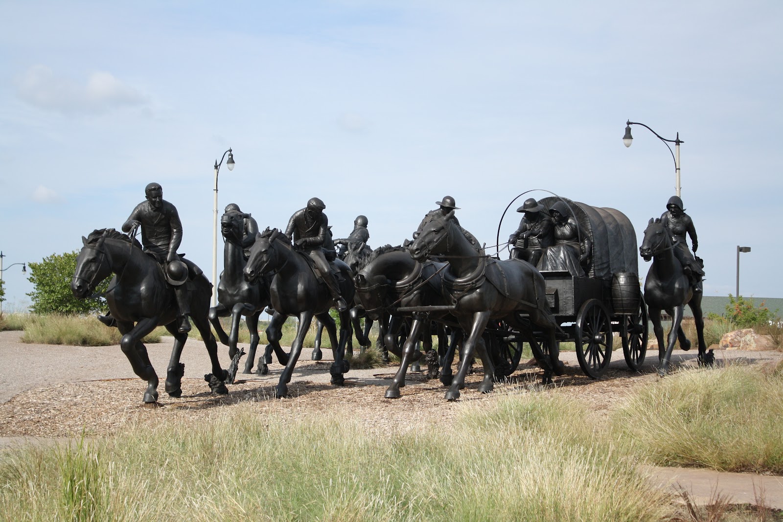
A light mist dotted the windshield as we left Emporia, Kansas, for Carthage, Missouri. The sun burned through momentarily by the time we drove through Olpe, only about ten miles.
The rail still stands as evidence
of soldiers' punishment for infractions of rules.
"We'll be on country roads all day," said Andy, "and that's more of the sun than I thought we'd see today, even though the high was a predicted 76 degrees." Stalks of Maximillian sunflowers and bright yellow Compass Plant flowers lined the roadside, adding even more color to the fields of yellow goldenrod and maturing soy beans. Autumn was in the air, in spite of warm temperatures, but trees showed little sign of changing color. I attributed the brown, yellow and gold of the fields to dryness; yesterday's rain with this morning's fog provided only stopgap alleviation.
By the time we had driven to Fort Scott, billowing grey clouds came and went, and temperatures reached near 80 degrees.
The Quartermaster's store held
supplies for life on the frontier.
Fort Scott, both a fort and a town, was established in 1842, as one in a line of protective forts from Minnesota to Louisiana to enforce "the promise of a permanent Indian frontier." Named for General Winfield Scott, the fort housed infantry and dragoons, elite troops of soldiers trained to fight both on foot and on horseback. These dragoons escorted pioneers south and west along the Santa Fe Trail in 1843 and parleyed with Indian tribes who threatened pioneers on the Oregon Trail in 1844.
Captain Thomas Swords designed the construction and organized the building of the fort. Carefully overseeing all phrases of development, he ordered it to be "the crack fort of the frontier."
"That's probably why it's in such good condition today, " I told Andy.
Almost all the infantry and dragoons were ordered south to fight in the Mexican-American War of 1846-1848. Those few left behind continued a schedule of building construction and maintenance.
With Manifest Destiny of the late 1840's, the idea that America had the divine right to expand from coast to coast, and with the winning of the war against Mexico, the frontier expanded westward and the idea of "a permanent Indian frontier" died a quick death. Fort Scott had outlived its usefulness, so the army abandoned the location in 1853.
Officers' quarters offer privacy for families in the backyards
with gardens, patios, shaded walkways and porches.
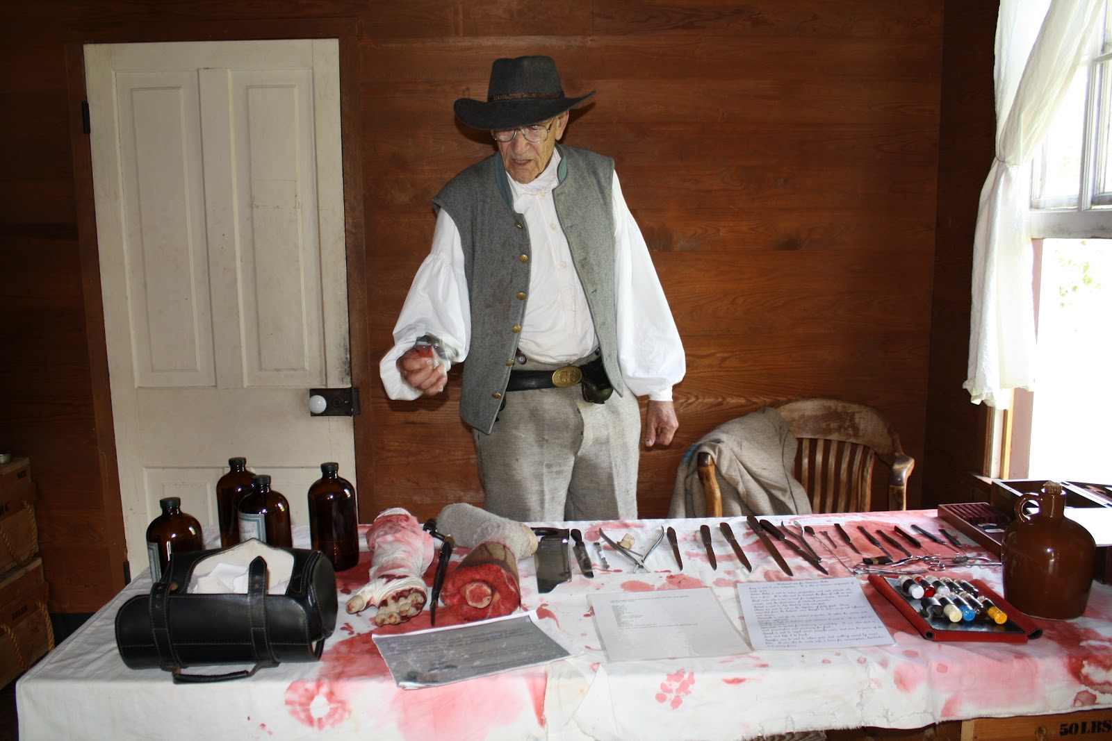
Up to that time, the biggest problem for soldiers at Fort Scott was boredom. "That would account for the alcoholism," I told Andy. The sign in the hospital said that soldiers suffered from "malarious fever, diarrhea and alcoholism." In the winter pneumonia was a problem, and the disease was usually fatal.
Every soldier served in the bake ovens on rotating assignment. But fresh bread was not the reward. Officers believed stale bread aided digestion, so bread sat two days on open racks before it was served, unless soldiers toasted the fresh loaves.
Infractions of all rules were strictly punished: sitting in the stocks, sitting on a rail about eight feet off the ground, carrying a log, standing for hours on a barrel, sitting in jail or remaining in solitary confinement.
A barn houses a six-pound field artillery piece and two 12-pound Mountain Howitzers, examples of weapons pulled across country for attack or defense.
After 1853, the buildings were auctioned and Fort Scott became a town, the center of westward expansion. When the Kansas-Nebraska Act of 1854 legalized the two territories for settlement, Fort Scott offered the gateway west. As the town grew as a supply center, so too did the controversy about slavery. The result was "Bleeding Kansas," an era when violence, destruction and psychological warfare prevailed in the region.
In the bake ovens, every soldier took a turn at baking bread
Andy and I stood on the green, once a military parade ground and then a town's grassy courtyard. To our left was the former officers' quarters, which by 1855 was the Fort Scott Hotel, nicknamed "Free State Hotel." This was home to abolitionists, who wanted to rid Kansas and the nation of the "peculiar institution," and free-staters who didn't want slavery expanded beyond its 1855 boundaries. To our right was the infantry barracks, which by 1855 had become the Western Hotel, headquarters for pro-slavery men, sometimes called Border Ruffians. Only a grass courtyard separated them. No wonder it all led to blows by 1858!  We read the history, a fascinating and different perspective from what we both had learned in school.
"This country did some pretty awful things," said Andy. "The Indians got screwed, and hundreds of Blacks were considered less than human."
By the time territorial strife had waned in 1859, nearly 60 had died and hundreds lived in terror throughout Kansas, because of the struggle over slavery. Kansas entered the Union as a free state on January 29, 1861. That brought the Army back to Fort Scott.
We tried to imagine what life here must have been like--a major supply depot for the Union armies of the West, a general hospital for the entire region, a gathering haven for those fleeing from war, like displaced Indians, escaped slaves, widows and children, homeless farmers. The lovely, quiet green where we stood must have been a scene of misery and suffering as it teemed with activity and life.
Confederates targeted Fort Scott's military stores and tried twice unsuccessfully to capture the fort during the war. Here too one of the first African American regiments engaged the Confederates in combat.
We read all the historical displays, saw the 20-minute film and checked out each building. Even after 1865, when the war ended, Fort Scott played a role in the nation's development. When the first railroad reached the area in 1869, squatters forcefully opposed the laying of more tracks south of the city. The Army returned from 1869 to 1873 to protect railroad workers and defend big business from American citizens. Funny how that argument continues in 2012!
On a parallel note, economics drove interests in the 1860's. People saw slaves as property to be defended. A 16-year old slave girl in 1857 sold for 50 ounces of gold, or about $1000. That value in 2012 is $93,500.  The total market value of slaves in 1860 was $4,000,000,000.00, which equates to $238,000,000,000.00 today. In 1860 about four million, or one out of every eight people, were enslaved.  And not just slave owners cared about the economics. "One half of the richest Americans in 1860 lived in the South. Owning slaves had been their fast track to greater wealth. Yet only 25 percent of all Southern families had slaves. Even poor white Southerners with no slaves were for slavery--reassured by seeing a class of workers whom they thought would always stay below them."
It sure sounded to me like Huckleberry Finn and his dad Pap.
This frame marks the foundation of the slave cabin where
George Washington Carver was born.
"It's so early and the weather is holding," said Andy. "Look at the map and direct me south to the George Washington Carver National Monument."
Along the way past rural homes, Andy said, "It amazes me how many dirt roads still exist in Kansas and Missouri." Some of them showed evidence of grinding poverty. "I can't believe people really live like this."
I shook my head; I totally agreed.
Carver, who became a symbol of interracial cooperation, died at Tuskegee Institute on January 5, 1943. That same year the federal government designated his birthplace in Diamond, Missouri, as a national monument, the first park in the country to honor an African American scientist, educator and humanitarian. The interactive museum was amazing, a showplace for children and adults to experiment and learn in honor of a scientist who believed "it was simply service that measures success."
Carver, credited with transforming peanuts into products such as ink, paper, soap, glue, dyes, massage oil, milk and cosmetics, was motivated by his love for all creation. The literature said, "For him, every life was a window on God and a mouthpiece through which the Great Creator spoke. He saw all living things as interrelated."
We walked the mile-long trail past the spot where he had probably been born, the site of an 8x8-foot shed that was wiped out by a tornado; along the pond where he learned to appreciate nature; through the house where owners Moses and Susan Carver lived; past the cemetery where the farm family is buried; and back to the museum.
In the woods the boy statue of George
Washington Carver overlooks
the land where he roamed and learned.
Carver's story was a fascinating one. A butterfly landed on Andy's shoulder. It was a Great Spangled Fritillary. Not far away a Buckeye butterfly fluttered over the sun flowers. We read the Carver inscriptions along the path: "You are the handicap you must face." and "Education is the key to unlock the golden door of freedom to our people." George Washington Carver was a "father" and innovator in his own way.
George was born around 1864 to Mary, a 13-year old slave purchased by Moses Carver for $700. Her second son, he was caught up in the guerrilla warfare of the Civil War on the Missouri-Kansas border when he and his mother were kidnapped. Moses Carver sent a man to find his stolen slaves, but only George was returned from Arkansas, orphaned and almost dead from whooping cough. He remained in frail health for years, which freed him from many chores around the farm and gave him time to explore in the woods. The Carvers raised George and his older brother Jim. In his autobiography, Carver wrote, "From a child I had an inordinate desire for knowledge, and especially music, painting, flowers and the sciences." He created a little garden hidden in brush not far from the house. Here, unbeknown to anyone, he nurtured plants that thrived under his touch. Later as a child he would be known as The Plant Doctor, and plants from all over the country would be brought to him for treatment.
Carver's voice from this
statue explains the values
he learned on the Carver farm,.
No colored schools were available near Diamond, so the Carvers permitted George to attend school in Neosho, eight miles away. He cooked for a wealthy family in Fort Scott, Kansas, to earn board, clothes and school privileges. A lynching of a black man in Fort Scott in 1879 so moved Carver that he left the town for good. Eventually earning a high school diploma with background in Latin and Greek, he entered business college in Kansas City, was admitted to Highland College and then refused for racial reasons, and finally earned acceptance to Simpson College in Iowa for art. The only African American at the school, his acceptance could be credited to the display of his painting Yucca and Cactus at the World's Fair. He opened a laundry to support himself and lived on prayer, beef suet and corn meal.
Transferring to Iowa State Agricultural College in 1891, he pursued agriculture and earned two degrees by 1896. That year Carver accepted an offer from Booker T. Washington to head the new Agriculture Department at Tuskegee Institute in Alabama.
Unusual art decorates a
gas station near Carthage.
The post was his dream job "to do the greatest good to the greatest number of my people." Here he was able to develop the peanut, a crop that would free African American farmers from the tyranny of "King Cotton," which had destroyed the soil in the South. He also wrote 43 educational bulletins for average farmers, several of which were distributed throughout the world.
Inside the museum I learned about the Short Course. Carver developed a two-week class in agriculture at Tuskegee Institute, a series of practical lessons for ambitious, young farmers. It featured free admission, affordable accommodations, and classes in the winter when farmers could attend. In 1904, he attracted 20 students; by 1912, there were 1500 enrolled. Carver understood the needs of the average person, and fame never changed this humble servant of the people.
Surrounded by one-story stores, the Carthage Courthouse
on the village green, looks like a medieval castle.
We headed toward Carthage, Missouri, for the night... couldn't find the White Rose Winery but enjoyed some unusual art along the way. And the Courthouse at Carthage stood out in the frontier environment.
We had had a moving and inspiring day, and, ironically, the two unrelated self-guided tours were intimately related after all.

Wednesday, September 26, 2012

Rain Makes Tallgrass Grow--TRIP 3

Limestone fences separate the Jones Ranch house and barn
from the fields of tallgrass where cattle roamed.
Emporia was blanketed with clouds, and a steady rain fell this morning. I can't begrudge them," said Andy. "This country needs rain so desperately."
At 9:15 a.m. when we drove toward Tallgrass Preserve, puddles lined the road, pond water level rose, soy bean fields looked refreshed and trucks splayed clouds of spray in all directions.
A barbed wire fence lines Windmill Pasture.
"We're in rain," said Andy, looking at the weather report, "but the worst of the thunderstorms are south of us."
Clouds hung low and with the big sky we could turn 360 degrees from the knoll at Tallgrass Preserve and point out pockets where precipitation fell in the distance.  But it didn't rain at Tallgrass. At least it didn't rain for the two hours we walked around the Z-Bar Ranch barn, ice house, chicken coops, garage and family garden or took the 1.5-mile Nature Trail in a loop to two overlooks.
On a lonely rise, Lower Fox Creek Schoolhouse stands
sentry as time passes.
The sun came out in Cottonwood Falls with its Chase County Courthouse, as Little Red lumbered over the cobblestone streets of town, but within minutes grey clouds moved back in and the dribble spotted the windshield again.
One pullout along the Scenic Byway (Route #177) stood out bright yellow against the prairie.  Hundreds of golden sunflowers, the state flower of Kansas, nodded in the breeze.
A red-tailed hawk swooped overhead, and in the distance, a lonely train whistle sounded its presence: Tooot, Toooooooooot, Toot, Toot.
Stalks of Maximillian sunflowers
color the autumn landscape.
With a misty sprinkle falling, we headed back to Emporia, the founding city of Veterans Day.
"It just doesn't know what it wants to do, and I don't want to get soaked," said Andy.
Even though clouds covered the sun south of Emporia, at Flint Hills National Wildlife Refuge, the rain held off. We walked the Burgess Marsh Trail, a concrete path out to a boardwalk, and spotted three birds of prey. At the far end of the boardwalk, a marsh of sun flowers past their prime surrounded the platform; at the near end, a woodpecker tapped loudly on a dead tree.
 I directed Andy down gravel Garner Road to the ponds formed by the Neosho River.  The water level, down at least three feet, looked murky and dirty.  Andy saw one large bird swoop down just as we pulled in, but otherwise all was quiet.

Flint Hills Great Plainess--TRIP 3

Last night thunder rumbled for an hour until the building shook, but Kansas City never got rain. "It's going to come when everything I've planned is outdoors," said Andy.
Of course. Murphy's Law.  We packed up, waved good-bye to Kansas City and headed southwest on Route 35 towards Wichita. Emporia, Kansas was our destination for the night.
Slightly rolling hills stretched as far as we could see.  "It's called the Flint Hills. Even though the land looks like it would be great for farming, a layer of rock under the surface keeps crops from growing," explained Andy.
Would that rock be flint?" I wondered.
"I don't know," he answered. He focused on the construction tie-up ahead of us.
Since it was too early to check into the motel, we headed to Tall Grass Prairie National Preserve. 
"As far as the eye can see" is the usual description of the
tallgrass prairie. Here that is about 30 miles in any direction.
"It's sunny here," said Andy, "and it's hot too."  This is the true prairie, and we saw the searing effects of the drought. Ponds had dried up and everything alive had yellowed.
"The Santa Fe Trail went right through here," said Andy, pulling into Tallgrass Prairie National Preserve, the 370th parcel set aside by the National Park Service. In 1996 the federal government worked with The Nature Conservancy to acquire this land for preservation.
"What's the deal here?" asked Andy when we entered the Visitor Center.
Ranger Heather told us about the National Park Service bus tour.
Ranger Eric chats with members of the tour group and
teaches us about the ecology of tallgrass.
Ranger Eric checked us on the bus with 12 others. at 11 a.m. We boarded and bumped along the rock trail, no more than two tire treads in the grass, to discover the wonders of Tallgrass. A flock of at least 30 pelicans circled overhead. "They probably touched down at Council Grove Reservoir to the north," guessed Ranger Eric.
Andy notices that each step in the grass of Windmill Pasture
crunches in the dryness of severe drought. This area
is more than ten inches below the normal yearly rainfall.
Part way out to the Scenic Overlook along Scenic Overlook Trail and with an eye on the American bison herd nearby, Ranger Eric asked us to de-bus for a history, geology and ecology lesson. "This is the 370th unit of the National Park System," he explained, "but it is the only unit specifically designed to preserve grasses." We learned that the ranch was acquired in 1994, at the request of Senator Nancy Landon Kassebaum-Baker from Kansas, who encouraged the National Park Trust, a non-profit group, to purchase the Spring Hill/Z Bar Ranch with the intent of creating a national park. On November 12, 1996, the 10,894-acre Tallgrass Prairie National Preserve became a national park unit. In April of 2005, the National Park Trust transferred its land ownership to The Nature Conservancy, who now works closely with the National Park Service for management and restoration.
"The prairie is threatened with extinction," said Ranger Eric. "We need to preserve this vanishing landscape. It is the most threatened ecosystem in North America. With only five and a half to six million acres, that's four percent of the original range, and two thirds of the remaining tallgrass landscape is in Kansas."
Ranger Eric talked about ecology, the study of 
This area of Great Plains was once covered by a vast inland sea.
Andy and I walk four miles to the ranch in the distance.
the shared relationships that living organisms have with their environments. He explained that grasses can thrive on 30 percent of the world's land surfaces, capturing billions of tons of carbon dioxide from the atmosphere and releasing oxygen, depositing organic material into the soil, and storing carbon for decades. "Our planet's survival and our survival could hinge on the survival of the grasslands," he said.
While he talked, we checked out the flowers and kept an eye on the bison herd.
Fall flowers, one of the favorite foods for cattle,
bloom everywhere. Bison prefer grasses.
"Trees don't grow here because there is not much soil," explained Ranger Eric, "with layers of limestone and shale just beneath the surface. Ancient peoples learned to adapt to the geology of the area and live in harmony with the land. Now the annual plants thrive because there has been so little rain. All the perennials have shut down." We saw yellow broomweed, blue sage, white heather aster and yellow curly cup gum weed. Lovely as it looked from a distance, the broomweed indicated a heavily stressed environment due to extreme lack of moisture.
One guest asked about the tallgrass. Ranger Eric chuckled. "True, it's not very tall. That's because of the drought. At this time of year it is usually waist high, but we are at least ten inches down in rainfall." Most of the grass barely reached our ankles. "But there is huge variety and diversity here," explained Ranger Eric. "The Tallgrass Prairie supports 70 species of grass, 500 species of herbaceous plants, 300 species of animals and 1000 species of insects."
A short drive later at Scenic Overlook, we learned that moisture, fire and grazing allow people and nature to co-exist on the Tallgrass Prairie, so the National Park Service practices patch burning, setting controlled burns to about 30 percent of the park every year. The rotational burns, natural from lightning in years past, destroy old thatch, which gives grass roots access to sunshine and moisture. The ash absorbs sunlight and nourishes the soil.  Ancient peoples, like the Kansa Indians, understood this. They set burns to encourage the growth of tender, young grass shoots, which attracted the bison.
"We have no Kansa left in Kansas," said Ranger Eric. "They were all relocated to Oklahoma in 1872."
Along the trail, a Texas Horned Lizard poses for us.
The bison herd stayed near their water hole in the distance. "That is a herd culled from the Wind Cave bison," said Ranger Eric. "We started with 13 a few years ago, seven males and six females. They had six young this year; one baby and one adult died. We are up to 20, and Windmill Pasture can support 75 to 100."
Before the group boarded the bus to return to the Visitor Center, Ranger Eric explained the origin of the name Flint Hills. He said, "Zebulon Pike, of Pike's Peak fame, wrote in his journals that he was 'passing through rough hills of flint.' The name stuck." We picked up pieces of flint and looked at the sharp, rough cutting edge. Funny how stories and experiences interconnect.
Completed in 1882, the Lower Fox Creek School served
the community for about 50 years.
As the group boarded the bus, Andy and I set out on foot across the tallgrass. We followed the Prairie Fire Loop Trail to the Davis Trail to the Schoolhouse Spur Trail for four miles to return to the Visitor Center.
The Lower Fox Creek Schoolhouse served the community from 1882 to the early 1930's. Desks and stove still exist inside, but the building was locked and the windows, clouded.
The Jones Ranch dominates the landscape.
With 30 miles of stone fence as reported by the 1885 census, the Spring Hill Farm Stock Ranch stood out against the gently rolling landscape. Here, Stephen F. Jones and his wife Louisa created a 7000-acre cattle ranch in 1878. His barn, 60 x 110-feet, housed animals and sheltered equipment and feed in the winter. The house was completed in 1881, but the Jones family only lived here ten years. Many other owners followed. By 1955, the Merrill Grain Company occupied the land. The bank bought the land from the Z-Bar Ranch in 1986, and in 1994 the house and 10,894 areas were purchased by the National Park Trust. What a treasure to preserve for history and ecology!

Tuesday, September 25, 2012

Hog Heaven--TRIP 3 (2012)

Rough Riding Andy
poses in the lobby of the Harley-Davidson Plant.
At 8:50 a.m. we were already in the parking lot of the Harley-Davidson factory on the outskirts of Kansas City. Bikes, probably at least 40 of them, arched around the front entryway. They were all Harley's and all different models.
"Look," said Andy. "The sign says not to touch because these are all employee bikes. If you own a Harley, you park right outside the front door of the plant."
Inside we were greeted by Curt at exactly 9:00 a.m. He held the door for us.  "Our first tour is 9:30 a.m.," he explained, "but you can try out the four bikes and shop in our store."
Perched on a touring Sportster,
Sue rides into Hog Heaven.
I hurried back to the car for the camera to get foyer pictures. No cameras, bags or pocket books were allowed on the tour.  Another sign said, Firearms prohibited.  "I guess Missouri is an open carry firearms state," said Andy.
Meghan started our tour with a ten-minute movie about the history of Harley-Davidson and an overview of the manufacturing plant.  Then she gave us the safety pointers and rules.
"Talk about private factory tour," I told Andy. Only one businessman joined us for a one-hour fifteen-minute-long walk through the facility.
From the film we learned that four young men built the first motorcycle in the early 1900's in a Wisconsin shed no bigger than a closet: Mr. Harley and Mr. Davidson and his two brothers.  Within a few years the start-up company built more than 10,000 bikes in one year. Within 16 years, they were making more than 25,000 bikes a year and had become the largest motorcycle manufacturer in the world.
Our safety measures and rules included wear goggles, pin on the visitor ID button, stay between the yellow lines at all times, touch nothing, and adjust the headset and earpiece as necessary to hear Meghan. We complied for the fascinating story of how a motorcycle is built.
Interesting facts from Meghan's tour and our own observations included the following:
1.  To get a job on the line, an applicant is given an aptitude test: 600 pieces spread in front of the individual and 45 minutes with a blueprint to assemble the handlebars. "If they pass the assembly in the time limit, they might be hired," said Meghan. "If they come close, they can still be tour guides," she joked.  Then she added, "No, I didn't have to take that aptitude test."
2.  This plant manufactures three kinds of bikes, including Sportster line bikes, Dyna line bikes and V-Rods. Everything is incredibly automated and spotlessly clean. Most workers even had on gloves.
3.  Quality is paramount. Every part is hand checked. Final smoothing and polishing is all done by hand. Each bike is roll tested for one and a half miles with a company gas line fed directly into the engine so no gas is put into the fuel tank, and during assembly each fuel tank is dropped into a water bath to check for leaks.  Two bikes out of every 100 are randomly chosen and road tested for 32 miles over a varied course and then cleaned before delivery.
4.  All bikes made in this plant have been pre-ordered by Harley dealers, and they are produced in the order in which they were ordered, one bike at a time on the horseshoe-shaped assembly lines.
5.  A single Sportster or Dyna comes off the assembly line in 55 minutes. The V-Rod, with exterior frame and water-cooled engine designed in conjunction with Porsche automotive, takes about two hours to complete a bike.
Kansas City serves as one of the 12 national sites
of the Federal Reserve Bank.
6.  Robot arms and automated hands move mechanically in every direction. Andy said, "This requires an incredible number of skilled and trained computer programmers, and most high schools don't teach that today."
We addressed postcards at Harley-Davidson's expense and said good-bye and thank you to Meghan for her highly educational and interesting tour.
Our next stop was the Federal Reserve Bank, Kansas City Branch, one of 12 regional branch Federal Reserves in the United States. The security was tight, but the tour, all self-guided, allowed guests to watch money being counted and bundled, read about the history of banking in the U.S., and watch a 20-minute movie about how Kansas City was chosen in 1913 as one of the 12 Reserve bank sites.
Especially interesting was the counterfeit display and the 27-pound gold bar cast in 1959 that was worth $759,456.00.  We tested our strength to lift it.  Andy pointed out a chart that illustrated the economic value of education.  In 2006, a high school dropout earned an average salary of $419 a week, while a person with a bachelor's degree made an average of $962 a week and a master's, $1140 a week.
We ate snack lunch in the park
that adjoined the Liberty Memorial.
Interesting facts from the museum included the following:
1.  The vault doors weighed nine tons each.
2.  All paper bills of larger than $100 were removed from circulation in 1969.
3.  A full pallet of $1.00 notes would be worth $640,000; a full pallet of $100 notes, $64 million.
4.  The major job of the Federal Reserve Bank is to keep banks supplied with currency and coins. Bills come to the Fed from the Bureau of Engraving and Printing; coins come from the U.S. Mint.
5.  About $4,000,000 in currency is destroyed in an average day.  I didn't think fast enough to ask whether that was in the whole country or just the Kansas City Branch of the Federal Reserve.
Before we left, the security guard invited us each to help ourselves to a souvenir: a bag of shredded money, about $165 worth. Good luck putting anything back together again!
Diana's Fountain celebrated the goddess, daughter of Jupiter.
"Today is our last day in Kansas City," said Andy, as he headed back downtown for a walking tour of more fountains: Diana's Fountain on Ward Parkway (the nude Diana was the daughter of Jupiter); the Board of Trade Fountain on 48th Street; adjoining river fountains; the Pomona Fountain (the nude Pomona was the goddess of vineyards and orchards); the Children's Mercy Hospital Fountain (Those girls were naked too.); and the matching Country Club Plaza mosaic fountains. "They don't count," said Andy. Dry, they were being cleaned for winter.
Outside The Star newspaper building,
another fountain highlights the grounds.
Finally, we headed for Hallmark Square, home of Hallmark Card Company, founded in 1910 by Joyce C. Hall and his wife Elizabeth Hall.
As the sun sank lower in the sky, we
found our last fountain in front of the
Kansas City government building.
Maxine, Hallmark's poster girl,
shows "attitude" in the Hallmark Museum.
The architect of the greeting card was affectionately known as Mr. J.C. The complex, a redevelopment project to help the city, includes beautiful fountains, but the tour was disappointing. Totally self-guiding through a museum maze of posted cards, it offered no working views of how cards were designed or created.  We DID meet Maxine, the Hallmark poster girl, and we benjoyed the International display with its birthday card in 12 languages. Hallmark, when you care enough to send the very best, prints cards in 30 languages and sells in more than 100 countries.
We headed out to see two more fountains: Grand and 18th at the corner of The Star newspaper building and Oak and 11th near the Kansas City Hall government building in Ilus W. Davis Park.
Andy followed the Cliff Drive Scenic Byway along the bluffs of the Missouri as we meandered some of the back streets.
"Get me to Route 35 or 29," he said, and I did.