Pages

Friday, September 30, 2016

RETIREMENT TRIP #7
Santa Wouldn't Retire in Christmas Valley
                                            Goose Lake did have water in it this past spring, according to the motel clerk.  What happened was the snow pack melted much earlier than usual, and there has been no rain all summer.  Lakeview averages 16 inches of precipitation per year, so every bit of moisture is crucial.  It’s just one more example of the climate changes from global warming, I thought.
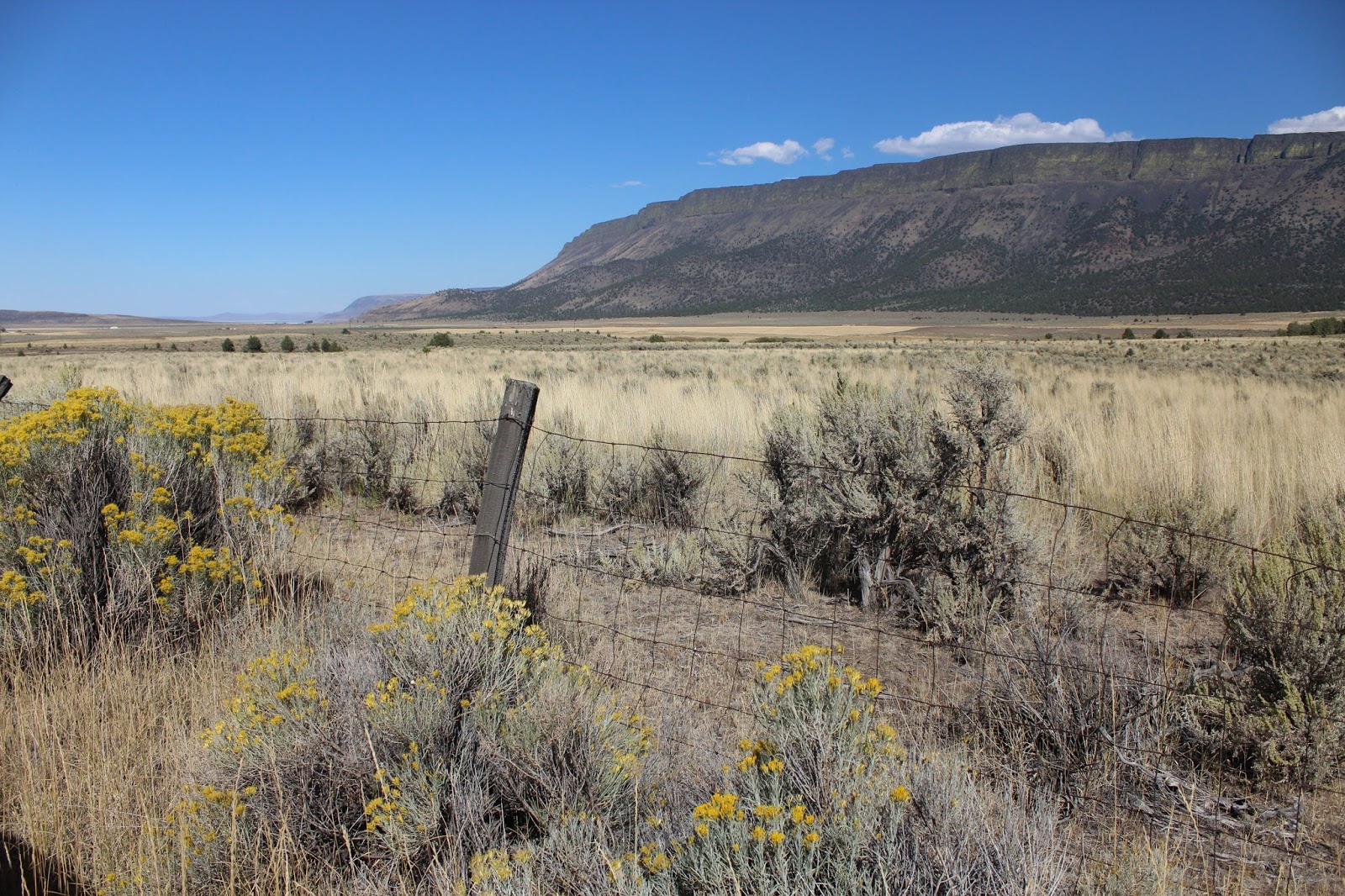
Bleak hills and lack of vegetation typify the Oregon desert.
“This doesn’t look like Oregon,” said Andy, as we drove northwest on Route #395.
I agreed.  “Oregon is supposed to be green with mossy trees,” I told him.  “It’s kind of like what people think when they hear New York… all big, bustling city, when most of the state is farm country.”
He laughed.  “This reminds me of Nevada.  Did you notice there isn’t even any grass in between the clumps of sage?  It’s land nobody wanted, so most of it belongs to the Bureau of Land Management.”
The dry bed of Summer Lake temporarily
offers  some grass for grazing.  
Hay is the only crop here.  We read that the hay is actually alfalfa, a more nutritious variety of hay.  It’s too cold and dry to grow anything else for profit.  But hay maintains the cattle in the winter.  There were tens of thousands of cows and millions of bales of alfalfa in the fields. 
We passed through the tiny town of Paisley.  All was quiet, except for the trucks at a local coffee shop and the cars outside the school.
Alfalfa grows abundantly in the
warm, dry air of the Oregon outback.
North of Paisley, Summer Lake was a dry white bed of minerals.  Cows grazed peacefully in fields surrounding the old lake bed.  A water truck heading inland kicked up dust along the dirt road.  We passed an overturned semi on its side in the ditch just before the bend.
“No! You can’t take a picture,” said Andy.  “The tow truck is there.  The driver must have fallen asleep at the wheel.”
Everywhere cows grazed—meandering and munching, lying down and walking.
There was some water in the northernmost end of Summer Lake.  There, the farms looked more profitable, and pivot irrigation sprayed water on hay fields.
Trunks of trees on Winter Rim suggest that fire had had a
hand in shaping this landscape.
The mountains to our left rose at least a thousand feet.  The whole slope had been burned over.  A one-room schoolhouse, painted white, stood out against the starkness of the steep, dark hillside, the Winter Rim of the Fremont National Forest.
“This must be good hunting ground,” said Andy.  Three hawks perched on three consecutive telephone poles. I wasn’t quick enough to capture them with the camera.
At the Fremont Memorial Rest Stop, the hills were starting to take on some fall color.  Birds twittered noisily in the poplar trees.
Butte lives up to its name as a
volcanic outcropping.
At Silver Lake, about 12 miles from the turn-off to Christmas Valley, the black lava buttes popped up again.  “Oregon is really volcanic,” said Andy.  We stopped at a pullout at Picture Rock Pass, elevation 4,830 feet.  A huge valley opened out before us.  The mountain on our right, named Butte at 5,698 feet, rose majestically in jagged black lava crags.  The sides were jumbled masses of lava chunks, broken off and tumbled down in all sizes and shapes.
Yellow Rubber Rabbitbrush and small juniper trees
dot Picture Rock Pass at lower elevations.
Four huge cattle trucks carrying live animals passed us coming up the hill. “Winter’s coming,” said Andy.  “Now is the time to sell off the fattest cows so you don’t have to feed then all winter.”
We both cringed.  “That’s a job I couldn’t do,” he added.  “Work in a slaughterhouse, that is,”
Such big, arid country reminds us of
the Nevada desert.
A flat-topped butte, named Table Rock, elevation 5,630 feet, looked rugged and uninhabited, but Andy noticed a cell tower at the top.  “That’s a high point,” he said.  Cultivated alfalfa fields spread beneath the butte in the valley as we turned due north.  Christmas Valley was 18 miles ahead.
“We know where the cattle trucks are coming from,” said Andy, when we passed a huge feeding and fattening lot.  Cows in pens ate at fattening troughs.  Surrounding fields with pivot irrigation and piles of hay bales supplied the fattening farm.  A high power transmission line brought in energy.
The driver of a hay truck takes the
third successive turn too fast!

Andy added, “I’d say there’s something big ahead.  That power’s probably from the Columbia River Gorge.  They are shipping to Las Vegas or California.”
Suddenly, a siren sounded behind us.  Andy pulled over and a Sheriff truck raced by.  Just ahead a sign read, “Sharp Curve,” and on the other side of the bend a hay truck lay on its side in the ditch, hay bales scattered in heaps.  “He took the curve too fast,” said Andy.  “He couldn’t hold it, but the load might have shifted was well.”
Ten miles farther, Andy realized we were on the wrong road.  “I didn’t intend to come to Fort Rock until tomorrow,” he said, “but now that we’re here, we’ll take advantage of the lovely weather.”  Temperatures were probably in the mid-70’s with lots of high fleecy cirrus clouds.
Fort Rock, a volcanic tuff ring or maar,
 looms large, rising 300 feet above the flat Outback plain.
Fort Rock, an immense natural stone stockade and a Registered Natural Landmark, towers 300 feet above the flat plain.  A third of a mile in diameter, Fort Rock is a volcanic tuff ring or maar.  It formed between 10,000 and 20,000 years ago, when the valley was part of an ancient lake covering as much as 200 square miles and as deep as 200 feet.  Here molten lava from deep in the earth met water-saturated rocks beneath the lake.  The steam produced violent explosions.  Hot ash and rock, tossed high in the air, fell in a circle, like a spewing fountain, and solidified in the tuff ring.
Andy waves from one end of Fort Rock.

Waves, driven by wind, eroded away the south part of the ring, leaving a horseshoe shape.
We walked the inside perimeter, amazed at the height and ruggedness of the area.  Like all of Oregon’s state parks, it was clean and beautiful but not easy to find.
Sue rests after the climb into the
center of the tuff ring.
Back on track, we retraced our 25 miles and located the correct road.  It meant going back past the overturned hay truck.  A young guy, probably in his 20’s, a girl and a German shepherd dog stood sullenly looking at all the bales of hay, still slightly green.
We back up quite a way into the Outback to photograph
all of Fort Rock at one time.
The truck had been uprighted, and firemen hosed down the spilled gasoline.  A sign nearby the road announced, “Wreck Ahead.”
We felt bad for the driver.


We drove through Christmas Valley, advertised as a retirement community, because it was too early to check in at the motel.  Andy was in search of Lost Forest, a biological anomaly.
The Lost Forest Research Area preserves a 9,000-acre stand of ponderosa pine growing in the middle of Oregon’s high desert.  These trees receive eight to ten inches of rain a year, whereas ponderosa normally require at least 14 inches.  No one knows how they live here so isolated, 40 miles east of the Fremont National Forest.  A water-resistant layer of soil may allow surface sand to trap and retain moisture, so these trees could be Pleistocene Age remnants when the climate was wetter and cooler.  The road in was seven miles of rutted dirt.  We weren’t even thinking about that one!

Crack-in-the-Ground is
another volcanic feature
of the Oregon Outback.
We gave up on the sand dunes.  They were only open to off-road vehicles anyway.  The pamphlet said they have reached 60 feet and are part of a 16,000-acre Sand Dunes Wilderness Study Area.
Nothing is marked clearly and most of the roads are dirt, but we tracked down what we thought was Fossil Lake by the clouds of blowing white dust.  We parked on a dirt drive and walked in about 500 feet.  “I’d never got out if I had tried to drive in here,” said Andy.  “The Fiesta doesn’t have enough clearance.”  Clouds of powdery dirt rose from our feet with each step.  Talk about soil erosion!   But we wanted to see this veritable treasure trove of fossils from the Pleistocene Epoch, 10,000 years ago.  Fossil Lake has yielded bones of 68 bird species, including flamingos, eagles and geese, and 23 mammal species, including mammoths, camels, beavers, giant ground sloths and three horse species.  The dust blew in clouds.  This is NOT a nice place.
For two miles the earth opens up and
explorers can walk between the cracks.
“I really feel sorry for anyone who lives to the east,” said Andy.
It was only later that we found out the lake we thought was Fossil Lake was really Christmas Lake, the centerpiece for what was to be the beautiful retirement community of Christmas Valley!
“Crack-in-the-Ground” is supposed to be off a paved road,” said Andy.  I noticed a small marker, but the road was certainly not paved.  We followed the washboard dirt for 7.1 miles, at first going 10 m.p.h. with our brains rattling and then learning that at 20 m.p.h. the car took the bumps better than we did.  It kind of glided over some of the washboard instead of settling into each groove.
The road took us high and deep into sage brush country to a distinctive volcanic feature called Crack-in-the-Ground.  We parked and followed a dirt path about .3-mile to a picnic area with a visitor sign-in pad.  Before us was a two-mile long fracture in a lava flow that reaches a depth of 50 feet in places and is 10 to 15 feet wide.  The two opposing walls form an exact match.  Stepping carefully, we made our way down into the 1,000-year old seam.
Earthquake! It was all I could think of!
The crack traps cold air, like being in a cave.  We probably walked about half a mile before turning around.  There was no way to scale the sides to get out.  “It goes on and on,” called Andy, a couple turns or crooks ahead of me.  I think we’ll have to retrace our steps, but isn’t it cool?”
He was absolutely right; it was fascinating, but I was uncomfortable.  All I could think of was earthquake!
“Okay,” I said, “but you had better wait for me!”
He usually does!

Wednesday, September 28, 2016

RETIREMENT TRIP  #7
The Changing World of Nature
                                                                    “Today you can tell fall is in the air here,” said Andy, coming in from checking the car.  He wanted to be sure the patched tire was holding.
“Fall is definitely coming,” said the owner and desk clerk at Antlers Motel when I checked out.  “There’s a certain nip today, and it isn’t the usual morning cooling off.”
A mist hung over Lake Almanor as we drove away from Chester.  It was almost imperceptible, but it portended moisture.  The seasons are changing.  We headed east toward Susanville.
Huge ranches extended as far as we could see on both sides of the road in between stands of pine.  There were thousands of cows grazing on the browning natural grass.  It wasn’t overgrazed, but the number of animals was huge beyond estimation—little dark dots as far as we could see in every direction.
Grazing land looks marginal along Route #395,
the highway from Canada to Mexico.
“Just outside of Susanville we pick up Route #395,” said Andy.  “That road goes from the Canadian border all the way to Mexico.”
“Stop at the Susanville sign,” I reminded him.  “I want a picture of MY town!”
By 9:00 a.m. a bright sun warmed the land and thoughts of fall slipped away.  Just then, we noticed a V-formation of geese flying overhead.  I guess they got the message too.  They were headed south.
I wanted a picture of the Susanville sign.  I had mentioned it more than once before.  But Andy couldn’t stop coming down the two-mile 6%-grade hill into town.
“We can get it going out of town,” I suggested, but he ended up on the wrong road, and we found ourselves in Johnsonville on a country byway.  Oh well!
Outside of Johnsonville the terrain leveled off with mountains in the distance.  Andy had said we’d notice a progressive dryness as we headed east.  He was right.  One more big down and everything was semi-arid.  Now the buttes were covered with sage and grass.  Fire danger was high.  They get some rain from the looks of the grass interspersed with volcanic lava, but the land is thirsty and moisture is still some weeks away.
Pivot systems of irrigation allow
ranchers to grow hay for winter feed.
We drove through Ravendale, population 20; and Termo, population 26; and Madeline, population 60.  It boggles my mind how people live in such tiny towns.“They actually have water here,” said Andy, as we passed Moon Lake just outside of town.  That may have accounted for the stacks and stacks of hay bales in the distance.   We guessed it must have been a company ranch.  A tractor plow going about 15 m.p.h. blocked the road temporarily through Sage Hen Pass at 5,556 feet.  The other side of the pass was Modoc National Forest.
Cattle by the thousands graze east of
Altures, California.
And then we came to Likely, population 99.  There was even a one-pump gas station, a general store, a small school house, the Most Likely CafĂ© that didn’t look open and a guy flying a Confederate flag.  Unlikely I want to live in Likely!
Far in the distance in the South Warner Wilderness Area, we could see a cloud of smoke.  It was probably a grass fire that was being allowed to burn.  It wouldn’t damage much here unless it reached the Modoc National Forest farther up the mountains.
Modoc National Wildlife Refuge is on the fly-way for migrating birds.  We stopped for a few minutes to check out the population.  A small V of Canada geese landed in the shallow water.  I read that grains are planted to offer a nutritional food source for the migrating fowl, and besides the geese, we saw two herons and lots of mallards.  I watched a deer move slowly through the marshy water.  Andy didn’t see it, but a sign said pronghorn antelope frequent the area.  It was probably a pronghorn.
On the other side of Altures, the ranches seemed more profitable.
Pivot irrigation systems meant water was available and we saw fields of beef cattle by the hundreds and storage shelters stacked with hay bales.  Here ranching was a profitable livelihood, but the abandoned homes along the road showed the “little guy” was being swallowed up and pushed out.
Goose Lake is little more than a puddle.
Andy stands at the end of what was the boat dock at
Goose Bay State Recreation Area.
“Here it is all about the water,” said Andy, “and not even just the water but cheap water.”
Goose Lake on the California-Oregon border is just about bone dry.  Whoever is using the water for irrigation has sucked it all.  It’s mile after mile of dry mud flats and grass with a few salt patches.  The sad part is that loss of the lake also means a drop in the water table.  This valley, probably once rich and fertile, is being devastated.  No more lake.
We turned in at Goose Lake State Recreation Area.  The flier said, “Goose Lake State Recreation Area is a green and shady destination of wildlife and wildlife watchers.  Its grassy expanse also makes it an inviting place to camp and find boating access.”
Some ad!  Not only was there no boat launch, there also was no water for miles.  Cows grazed everywhere on the dry, yellow grass.  Maybe a huge rainfall would recreate a shallow lake, but for now Goose Lake is no more.
The Abert Rim, a scarp, stands
2,000 feet above the valley floor.
In a dry land, the escarpment captures
water and filters it down to salty lakes.
The Abert Rim is one of the highest and longest exposed scarps in North America, rising 2,000 feet above the valley floor and continuing for nearly 33 miles.
We were intrigued by the green lichens growing high up on the side.  It’s also one of the most prominent and visible fault scarps in the country.  More cataclysmic changes may be in store for southeastern Oregon than the drying up of lakes like Abert at the base of the scarp.  Mount St. Helens is evidence of that.
Bright green lichens grow high
up on the edge of the ridge
Millions of years ago a blanket of lava several thousand feet thick covered southeastern Oregon.  Then continental plates shifted.  The Abert Escarpment is actually the face of a tilted fault block.  Finally, 20,000 years ago during the Ice Age, rain and runoff carved away at the ranges to form lakes in the valleys in between the plates.  It’s still “high country.”  The town of Lakeview at the southern end is 4,800 feet in elevation.
Lake Abert looked completely dry with white salt flats until we drove a little farther north.
“The literature said it was totally dry,” said Andy, “so they must have gotten some rain last year.”
Globs of salt floated near the edge and the “beach” was lined with white brine.  We could smell it too, even inside the car with windows closed.
What remains of Lake Abert
trickles down from the Escarpment.

Brine shrimp live here, so the area attracts sea birds.  I read the informative sign.  It explained that 10,000 years ago Lake Abert was part of a 460-square mile basin of water known as Lake Chewaukan.  As the climate warmed, mineral salts that had been dilute in this ancient sea concentrated in what was left of the smaller lakes.
Marsh plants on the edge of the lake and brine shrimp
attract shorebirds and waterfowl.
Now millions of brine shrimp in the salty water attract shore birds and waterfowl.  The shrimp can withstand below zero temperatures and can live with 98% of their moisture gone.  They may produce hundreds of eggs in their two-month lifespan.   Eggs take about two days to hatch.  Their actual adult size is about 5/8 inch.  It’s no wonder birds come here for easy eating. 
The freshwater streams that feed Lake Abert are vital for land-dwelling wildlife.  Big Horn sheep live on the adjoining escarpment.
We stopped again, marveling about the salt-tolerant grass that was growing along the margin.
All the remains of most of Lake
Abert is a vast salt flat.
Salt flats spread for miles
where a healthy lake once existed.
“And it’s all volcanic,” said Andy.  Huge chunks of basalt had rolled down the hillside.  Some rested in the salt flats below us.  People had walked out to the rock.  We could see the footprints, but the prints were embedded.  It wasn’t dry entirely.
Basalt rocks tumble from the hillside onto the salt flats.

Farther out the strip of blue water shimmered.  In the sun it was 90 degrees, and there was nothing to block the sun.  Only the deepest part still had some water.  The northern area was solid white salt flats.  A few birds swooped overhead, and Andy watched some wading in the shallows.  There wasn’t much water, but salt-tolerant marsh grass survived.
With a close-up of the
basalt rocks, the water
reflects the opposite shore.

 
Around one bend a herd of cows munched on the grass.  “They must have water troughs,” said Andy. “They couldn’t be drinking from the lake.”  At least the grass is being utilized in a practical manner.
Little is left of Lake Abert.
What a different world!  And this is Oregon.  It’s NOT green.
Going back toward town, we saw that the salt flats looked grey in the sun instead of white. 
And there was still a flow from the scarp in a center stream.
As Oregon changes, environmental
care becomes all the more crucial.
But a little more time without rain and it will dry up completely.
There will no longer be a Lake Abert at the foot of the Abert Escarpment.


Tuesday, September 27, 2016

RETIREMENT TRIP #7
Low Pressure Brings Signs of Seasonal Change
                                                 Kitty-corner across the street from Antlers Motel in downtown Chester is a tire center.  For us this morning that was the quintessence of the word “convenient.”  Dressed and ready to hike before 8 a.m., we discovered the Fiesta had an almost-flat tire on the back passenger side.  The light flashed “Low Tire Pressure” again.

The dusty Mill Creek Trail leads us through
groves of pine and across meadows.
“It’s either a leak around the rim from the gravel road bumping or I picked up a nail,” said Andy.  “It’s not down to the rim, so we can drive it across the street.”
We did, and half an hour later, minus one large screw embedded in the tread, we were on our way.
Andy picked our trail for today, once he had decided there was no way we were driving back down the Drakesbad gravel road.  He chose Mill Creek Trail to Mill Creek Falls, the largest waterfall in the Lassen Volcanic National Park, with a drop of 75 feet.  It was off a main road, parking available, not too long a hike, located at a lower elevation, and not too much climbing along the trail.  Sounded doable!
We set out at 9:20 a.m.  The dusty trail immediately descended.  Little puffs of black dust rose from our heels with each step, and before the trail leveled off the first time, my pants had fine powdery black dust coated from the knees down.
A lone dead pine, branches
drooped from years of heavy
snow, hugs the hillside.
“I don’t believe that guidebook,” said Andy, after the first mile in.  “It said 300-foot difference in elevation.”
“Right!” I told him.  “That’s a total of 300 up and 300 down each direction.  It doesn’t say how many times you do it!”  I was joking, but we had come up and down repeatedly.
The trail descended to a crossing of West Sulphur Creek on a footbridge, and then it passed around hillsides of dried out mules ears.  They rustled with each little breeze.  
Few people see Mill Creek Falls
drop 75 feet into the canyon below.
Gradually downhill through three or four open meadows, it followed through forested areas to the Mill Creek Falls, a distance of about 2.1 miles.  The trek back was harder, because much of it was uphill the 2.1 return miles.  But it was then with more frequent water stops that we appreciated the views of Brokeoff Mountain and Mount Diller.
The waterfall was lovely.
At the confluence of two
streams, Mill Creek Falls
cascades in series.

Mill Creek Falls drops suddenly right near the confluence of East Sulphur Creek and Bumpass Creek.   No fish live in the streams near the falls or for some distance below the falls, because there is too much sulphur from the thermal areas above.  Farther downstream, fish can survive because the water is diluted.
We climbed to the top of the falls and took the boardwalk.  With the two streams coming together and vast contrasts in lighting, it wasn’t an easy photograph.  
Flowers still bloom in the cleft of the
rock at Mill Creek Falls.
Then we faced the long trek back, definitely harder going uphill at the 5,500-foot elevation.  In the 4.2 miles, about 2.7 hours, we passed one middle-aged couple going the other way.  And they weren’t carrying water!
Lake Almanor, just south of Chester, is a huge manmade lake in Plumas County, surrounded by national forest.
On the trail back out, we catch a glimpse
of Brokeoff Mountain near Lassen.

We drove along the 13 miles to the south end and browsed in a wood carving shop.  The carver had hundreds of chain-saw carved bears priced about half the asking rate as New York carvers, but we had no way of transporting.
The lake, about six miles wide, was formed by the damming of the Feather River.  Known as a recreation paradise, the lake is lined with private cottages, campgrounds and an occasional boat launch.
Only once did we get a view of Mount Lassen from one of the pullouts. 

Although low now, Lake Almanor holds
plenty of water going into the rainy season.
Things definitely seem to be closing up for the season here.  Maybe the high off shore is starting to break.  Low pressure is moving in, and fall is coming.  A few puffy clouds lined the blue horizon, and in spite of the penetrating sun at midday, the evenings are cooling off.  Even the Visitor Center at Lassen had very limited supplies.
“We’re just about ready to close for the season,” said the clerk.

Monday, September 26, 2016

RETIREMENT TRIP #7
Earth Blows Off Steam!

                                                                             The car said 43 degrees this morning, so it would be in the 30’s on Lassen.  We grabbed our jackets before heading out.  It was 40 miles back to our long hike at Bumpass Hell this morning, so at least there was time for the sun to warm things up.

The Bumpass Hell Trail climbs across
rocky ledges and low growth manzanita.
Sections of the park road are actually scary to drive with no shoulder, no guard rails, no trees and a thousand feet straight down.  Andy commented as well, as he rounded the twisting bends and grabbed the sun visor to deflect the morning glare.   Luckily we had the road to ourselves.
The trail to Bumpass Hell
takes us past Mount Diller.
“I think today will be quiet here,” said Andy.  “Yesterday was the weekend crowd.” 
We didn’t hike Bumpass Hell yesterday, because every single space in the parking lot was filled—probably at least 60 spots.  Today there were three cars, and ours said 56 degrees by the time we parked.  But we took jackets just in case.
It took us two hours round trip to go the three miles—500 foot rise, 250 foot descent in one direction.  But what an education! 
Brokeoff Mountain and Mount Diller
form the backdrop for our hike.
Mud pots bubbled and belched the thick, pasty ooze; fumaroles puffed clouds of steam, and groundwater boiled in pools.  Andy read one sign that recorded 322 degrees, the hottest temperature registered for an active fumarole area on earth.
As the trail winds downhill,
Bumpass Hell comes into view.
We walked all the boardwalks.  Sulphur smell permeated the air.  Clouds of putrid steam rose and fell around us.  The white was so blinding that even a camera speed of 4000 wasn’t fast enough for pictures.  I tried anyway.
A steaming mass of sulphur and clay
earns its name early Monday morning.
Interpretive signs explained that we literally stood on magma, chambered miles below our feet.  It is the same magma that fed the eruptions of Lassen in 1915.  The magma superheats groundwater deep in the Earth.  Steam, as hot as 464 degrees Fahrenheit, rises and condenses back to water, mixing with percolating water nearer the surface.  The mixture produces sulfate water, as hot as 200 degrees Fahrenheit, that escapes through hydrothermal features.
A mudpot bubbles away at Bumpass Hell.
A mudpot is the intermediate phase between a fumarole or steam vent and a boiling spring.  In a wet year, a mudpot can become saturated, allowing sediment to thin and settle and forming a boiling spring.  In a dry year, a mudpot can dry up and just emit steam as a fumarole.  The surface material is in a constant state of change.

Any fool who tries to find gold in the
Pyrite Pool will not end up rich!
Bumpass Hell occupies the old eroded vent of a dormant dome volcano called Bumpass Mountain.  More than 75 fumaroles, hot springs and mudpots compose this 16-acre hydrothermal area.  And surprisingly enough bacteria live in the boiling water.
A fumarole steams away
at Bumpass Hell.
The black scum on the surface of the boiling pool is pyrite and the frothy mass contains tiny pyrite crystals, an iron sulfide mineral more commonly known as Fools Gold.
Iron leaches from the rocks below and combines with sulphur as it rises to the surface.  The steam emptying into each Pyrite Pool only slightly tempers the heat.  The up-flow of Bumpass Hell’s superheated steam is like a stove burner always on high.  And plants like bog-laurel and mountain heather still grow near the edge.
Andy checks out the fumaroles at Bumpass Hell.
 

Big Brother is the hottest fumarole—within a non-eruptive volcano—in the world.  Steam temperatures can reach 322 degrees Fahrenheit.  By contrast though, flowing lava can be as hot as 2000 degrees Fahrenheit.  Constant churning action is increasing Big Brother’s size.  Even some of the boardwalk has been engulfed.
Looking out toward Big Brother on the
left, we are amazed at the forces
that are underground.
We stopped for lunch at Sulphur Works.   Weather-wise, the high is still in effect for this part of California.  There wasn’t a cloud in the sky, and at noon our car read 73 degrees at around 8,000 feet in elevation.
Big Brother grows by absorbing surrounding crust.
For the afternoon we drove back through Chester and down to the south end of Lassen Volcanic National Park.  The last two miles of road turned to gravel and then badly rutted gravel, but a mile past the ranger station we found the campground and signs for trails.
Andy chose Boiling Spring Lake instead of Devils Kitchen because it was a mile shorter.
Brokeoff Mountain forms a
backdrop for lunch stop nearby.

So at 1:15 p.m. we set out with water and cameras.
The trail crossed a meadow on stretches of boardwalk, bridged a fast-moving stream and went through forest areas of incense cedar, ponderosa pine, Douglas fir and sugar pine.  Much was gently uphill for over a mile until it reached the pale green lake.  This was horseback riding country, but we didn’t meet any on the trail today.
Cold Boiling Lake actually bubbles with heat in the center.
Mudpots and fumaroles line the edges.
Steam vents located under Boiling Spring Lake keep the temperature of the lake around 135 degrees.  Signs everywhere warned hikers to stay on the trail away from thin crust and crumbling edge.
The southeastern shore was lined with bubbling mud pots and steaming fumaroles.   Water in the middle was actually boiling.
“The picture I saw was probably taken in the winter,” said Andy.  “There was steam everywhere.”
He guessed that an early morning visit when the air temperature is much cooler would show more steam.
It was a lot easier walk back downhill, and meeting other hikers on our return trek, we learned a little about exclusive Drakesbad, a pricey lodge at the end of the gravel road that features total luxury in the wild.
Sue tries her hand at wildlife photography as a tubby little
chipmunk poses for her with pine nut on a piece of red dacite.
We were glad we had planned for a reasonable finish as far as time was concerned.  On the way back down the gravel road, the Low Tire Pressure warning flashed in the car.  So we spent the next hour washing the car and looking for service stations with working air pumps and meters to read the pressure.  Mission accomplished!