Pages

Sunday, September 29, 2013

More Travels-Verde Valley Retirement

Verde Valley Retirement

"We'll be back in the desert today," said Andy, as we prepared to leave Flagstaff for the Verde Valley. "You can wear shorts again, even if Flagstaff recorded 27 degrees this morning."
By the time we reached Montezuma's Well at 8:45 a.m., it was already 75 degrees.
With plenty of water, the Southern Sinagua at Montezuma's
Well irrigated fields of cotton and agave.
 Ranger Case and Volunteer Barbara welcomed us to Montezuma's Well in the comfortable early morning hours. Standing in the shadow of the Ranger Station, we chatted a-politically about government shut-downs, health insurance, unemployment and volunteering.
"Can you collect unemployment if parks close for government shut-down?" asked Andy.
"I don't know," replied the ranger. "I never tried it before."
We all shook our heads over the wrangling in Washington.
 Montezuma's Well is probably the most studied natural spring in the world. It holds 15 million gallons of water. The water percolates up through Travertine limestone and replenishes the natural sink at a constant rate. The water fell as rain water atop the Mogollon Rim to the north 10,000 years ago. Over millennia it has percolated slowly through rock until it reached a vertical wall of volcanic basalt that acts like a dam, forcing it back up to the huge underground cavern sinkhole that is Montezuma's Well. Then it empties into Beaver Creek at a constant rate so that about ten percent of the Well is replenished every day.
No bottom can be ascertained for
Montezuma's Well, and the water stays
at a constant level all year long.
No fish can live because of high levels of carbon dioxide from the dissolved Travertine rock. But Montezuma's Well swarms with leeches, water scorpions, amphipods, snails and diatoms that are found nowhere else in the world. During the day the amphipods, crustaceans that look like tiny shrimp, feed in the center of the Well, out of the reach of ducks. At night, while larger predators sleep, endemic leeches rise to feed on the amphipods. The amphipods flee to the edges on the surface, where another predator, the water scorpion, waits. At this lovely oasis in the harsh desert, the nightly struggle between life and death goes on.
Ancestral Puebloans channeled the water as it emptied into Beaver Creek to irrigate their fields on the mesa. Evidence of up to seven miles of irrigation ditches lined with rocks have been unearthed in the area. These Indians built more than 30 rooms along the rim. Their pueblo here was one of 40 to 60 that dotted the valley.
Modern Hopi and Pueblo people still consider this land of their ancestors as sacred. They tell stories of "the monster of the Well" that protected the sacred water. Andy and I took the trail down to the outlet. There a man and his Native American wife plunged their arms up to the shoulders in the 74-degree water.
"It feels purifying and sacred," she said to him.
As we left, Andy whispered, "He drank some water before you got here. I guess it's pure, but I certainly wouldn't take a chance. The well looks polluted."
A sign on top explained that the water in the Well itself contained high amounts of arsenic. Bones of people and animals studied by archaeologists showed those who consumed quantities of water from the Well, not Beaver Creek, probably suffered greatly.
We read the informative signs. The Sinagua peoples who lived here raised cotton and agave, a desert plant used for fiber. As skilled weavers, they probably traded textiles for goods and products from hundreds of miles distant. With water abundant, it seems they had an advanced culture.
One of the best preserved ruins in the
Southwest, Montezuma's Castle
earned its name from its Aztec reputation.
Andy would choose Montezuma's Castle for his home site though. This valley of the Beaver Creek seems verdant and protected, probably why the ancients chose it as home. Cicadas sang to us as we walked the paths. Flowers in yellow and purple bloomed everywhere. A hot sun beat down, but the grasses and sycamore trees bent in the breeze. It was a pleasant valley indeed with the reliable, albeit dirty looking, water of Beaver Creek in ready supply.
Southern Sinagua farmers settled here in the early 1100's and began building a five-story, 20-room dwelling in a cliff alcove 100 feet above the valley floor. So well built and so protected from the elements, it has stood for more than 600 years and is one of the best-preserved prehistoric structures in the Southwest. Montezuma's Castle got its name when early settlers marveled at the structure and assumed it was Aztec in origin.
The Southern Sinagua who lived here relied on a diet of corn, but there is evidence that they mined a salt deposit a few miles from present-day Camp Verde and traded salt widely throughout the region.
Fine artisans, the Southern Sinagua crafted reddish-brown pottery, undecorated but highly polished, bone awls and needles, woven cotton garments and ornaments of shell, turquoise and a local red stone called argillite.
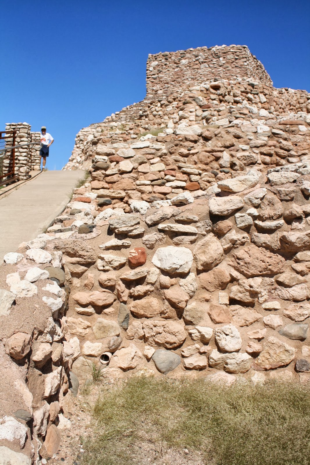
High on a ridge in the Verde Valley, the Tuzigoot ruins
tower over the surrounding landscape.
Lots of tourists milled around the cliff dwelling, reading the signs and marveling at the accomplishments, and stood near the diorama and in the Visitor Center. "I never knew anything about this," said one older lady. We directed her to Montezuma's Well and Tuzigoot.
Our next stop was Tuzigoot National Monument. Apache for "crooked water," this Southern Sinagua settlement developed in stages between 1125 A.D. and 1400 A.D. The ruins sit on top of the summit of a long ridge that rises 120 feet above the Verde Valley.
"That's the original pueblo," explained Volunteer Don from the rooftop. He showed us the inside room, his favorite cooling-off spot. "The roof was raised in here by the WPA in the 1930's so tourists could walk through. It's not authentic at all because the Sinagua men were only 5'4" and women, 5'1". We chatted about volunteerism and shared the blog site.  "Keep active," Don advised. "You have to keep your mind stimulated."
"Good advice," I told him. "If I were a Sinagua woman, I'd be dead."
Steep trails lead up to the top rooms
at Tuzigoot ruins.
"Yes, you would," he grinned. "A quarter of children born then died before they were two years old, and another 35 percent died before they reached their 20's. If you lived to be in your 30's, you'd stay in the lower rooms, because you'd have such bad arthritis, you couldn't climb, and no one lived beyond 40."
As today's retirees, we all chuckled.
Tuzigoot began as a small cluster of rooms for about 50 people. The original pueblo of 1125 A.D. was two stories high in some places with 77 ground-floor rooms entered via ladders through openings in the roofs. In the 1200's the population doubled. By 1300, it had doubled again as refugee farmers fled the drought of outlying areas. Then the pueblo probably had 86 ground-floor rooms and 15 second-story rooms for 225 people. No one knows the real reason why Tuzigoot was abandoned by 1400, more than a hundred years before the first Europeans rode into the valley.
Volunteer Don also told us that young children were buried under the dirt floor of the family's pueblo room, probably so their spirits would remain or so the parents could retain the promise of fertility.
Carpets of yellow flowers blanket the hillside
above the marsh at Tuzigoot.
Adults who died were placed with a few personal possessions in the soft dirt of the trash mitten outside.
Andy asked, "I've never had a chance to ask this, but what about sanitation? I heard somewhere that they went inside their houses."
Volunteer Don laughed. "No, there was a room at each end of the pueblo," he said, "but, of course someone had to clean it out periodically."
What a chore that must have been! I sure hope he earned a whole lot of extra corn.
Before we left Tuzigoot, we walked the quarter-mile Marsh path. Butterflies glided by every few steps, and with all the wild flowers, the honeybees kept up a constant communication. Part of a cattle ranch at one time and damaged by tailings from the copper mining industry, the marsh is now protected by the U.S. Park Service and is recovering. Beavers make their homes in the fresh water, birds winter in the area, and larger mammals frequent the pools and hide in the lush vegetation. No wonder the people of Tuzigoot chose this spot as their home in the desert.
A private trail with public access, the Adobe Jack Trailhead
offers hikers spectacular scenery in Sedona.
We headed on up the mountain to the ancient mining town of Jerome. "You bought a copper bracelet here many, many years ago," said Andy, as he looked for a place to park. The steep streets teemed with tourists. "There was just about nothing here then except a few hippies and a whole bunch of tumbled-down buildings." Now Jerome is an artist colony and Western hang-out with cool, little souvenir shops.Our next stop was Sedona, a classy town set in the canyon of red rocks at 4,500 feet. A cruel twist of fate or sight-seeing driving took us past a local craft fair. "Let's browse," said Andy, pulling in to park. But even though I found plenty of wonderful things I could cram into my suitcase, I wasn't allowed to shop!
Red rocks rise behind
the Chapel of the Holy Cross.
 In Sedona, Adobe Jack Trailhead pullout provided a viewpoint for pictures of the valley with its red rocks.
Simple and modern, the Chapel of the Holy Cross in Sedona
is on the National Register of Historic Places.
Much of the area around Sedona is undeveloped. "That's because it's Coconino National Forest," said Andy. He headed to the Chapel of the Holy Cross. Built in 1956, it is on the register of National Historic Places. Incredibly beautiful in its simplicity, the Chapel occupies a unique setting against the red rock canyon. The modern building dominates the point of rock, and the cactus landscaping is magnificent. Event the usually stick-like ocotillo were bending with the weight of green leaves.
In the late afternoon shadows bring out the color of the red
rock cliffs around Sedona, Arizona.
Our last stop around 4:00 p.m. was Yavapai Viewpoint. Shadows crisscrossed the red canyon walls, but the formations stood out sharply against a cloudless sky. Even in late September flowers bloomed everywhere. Sedona is my kind of first-class town. "I could retire here," I told Andy.
"You couldn't afford it," he said.

More Travels 4--Variety Spices Travel

Variety Spices Travel

In Flagstaff the giant cell towers that look like straight, tall Douglas fir trees, blend right in to the environment. They don't look a bit out of place. Andy said there was a move to put one in Newtown that was drawing a lot of protest. It wouldn't fit naturally there like it does here.
Chunks of limestone mark the site of ancient homes
in Walnut Canyon. 
Walnut Canyon was home to ancient Hopi and Zuni ancestors, sometime after the eruption of Sunset Crater between 1040 and 1100 A.D. The nomadic wanderers or pit dwelling farmers who lived near the crater probably lost homes and hunting grounds. It was then that they moved into the Kaibab limestone canyons, now called Walnut Canyon.
Recent findings suggest increased rainfall with more water in the canyon, new water-conserving farming practices, trade and a general population increase in the Southwest may have prompted the development of community canyon living between 1125 and 1250 A.D.
The Ancestral Puebloans who lived here were Sinagua, Spanish for "without water." They called their new home talatupqa, meaning "long canyon."  The 20-mile length and 400-foot depth contains mini plant life zones spanning the West from Mexico to Canada. At the top is the Upper Sonoran desert with yucca and prickly pear cactus; at the bottom is riparian riverbank community with boxelder and Arizona black walnut, for which the canyon was named.
Only the few larger rooms represent living quarters.
Most areas have been identified as storage bins.
These Puebloans lived here in cliff dwellings, farming small nooks on the mesa and canyon walls, hunting deer and small game, gathering an assortment of useful plants and trading. Acorns from the gamble oak were a dietary staple, and the fruit of the hedgehog cactus supplied vitamin C, calcium and potassium. Sinagua used yucca for food, soap, fiber and construction materials like thread and rope.
The cliff dwellings of Walnut Canyon were occupied for little more than 100 years. By 1250, the occupants had moved southeast along Anderson Mesa and were eventually assimilated into Hopi culture. Their cliff dwellings, sealed shut when the people left on what the Hopi believe was a religious quest to have all clans come together, remained undisturbed until the late 1800's.
Lennox Crater Trail ends in a field of cinder pieces
where very little can grow.
Then the railroad brought souvenir hunters--women in long dresses and bonnets, men in long-sleeved shirts and ties--all armed with picks and shovels. Theft and destruction prompted local efforts to preserve the canyon. The result was a 1915 declaration by President Herbert Hoover of a national monument. 
In the canyon, the ancient homes usually faced south and east to take advantage of warmth and sunlight. Archaeologists suggest it was the women who built the homes, fashioned from shallow caves eroded out of the limestone cliffs by wind and water. The limestone rock walls were cemented with a gold-colored clay, found in another part of the canyon. Wooden beams reinforced doorways. Walls were plastered with clay inside and out. Men farmed small pockets on the semi-arid canyon rim. They hunted small game and gathered more than 20 species of plants. This life in the canyon probably evolved after departing the rimtop area closer to Sunset Crater.
Lennox Crater Trail at Sunset Crater took us straight up the side of a cinder cone along a path of loose, crumbled cinders for 300 feet in elevation to more than 7,000 feet. Andy said, "It sure feels like more than 300 feet up."
On the south face of Sunset Crater little can
grow in the rough, nutrient-poor cinders.
I agreed.  Tall, straight Douglas firs and Ponderosa pine dotted each side of the trail, but the only ground cover was dropped pine needles and a few small grasses. From the top we could see snow in the crevices of the San Francisco Peaks.
Sunset Crater is a 1000-foot volcanic cone with two lava flows. Erupting sometime between 1040 and 1100 for as long as a year, Sunset Crater is the most recent in a six-million-year history of volcanic activity near Flagstaff. Natural forces that created Sunset Crater also created more than 600 volcanic features in the area, including the San Francisco Peaks, which in turn have affected climate and habitat for all living things in this region.
Sunset Crater started when molten rock sprayed high in the air from a crack in the ground, solidified and fell back to earth as large bombs and smaller cinders. Periodic eruptions with debris around the vent created a 1000-foot cone. The lightest, smallest particles dusted 800-square miles of northern Arizona with ash. Closer to the base, two lava flows--the Kana-a and the Bonito--destroyed all living things in their paths. New gas vents produced spatter cones, and cooling lava pushed through cracks for squeeze-ups. A final burst of activity after six months or a year gave the cone its name. The colorful glow when red and yellow oxidized cinders shot from the vent reminded people of a sunset.
From Desert View Overlook, we can see the
Colorado River far below.
When a volcano erupts, life begins anew. The Lava Flow Trail, a one-mile loop, demonstrated just that. Few trees grow on the south-facing slopes because the cinders don't hold moisture. But no ruts from erosion run-off exist either. The snow melt and rainfall sink in. This would help to explain the adjustments made by ancient Indian farmers. Legends say that the eruption "cleansed" the land, and tribes today still hold these lands sacred. A picture from 1905 of the south face reveals limited growth on the mountain in 100 years, and the eruption blanketed 64,000 acres of farmland and hundreds of pit houses.
Flowers bloom everywhere
in late September.
It changed people's way of life, but it also brought advancement and comunity. History can teach us if we only accept the lessons.
We headed to the South Rim of the Grand Canyon at 1:15 p.m. with the intent of just driving from viewpoint to viewpoint.
Desert View near the East Entrance Station was crammed with foreign tourists. Maybe they were trying to catch the main attractions before the government shuts down on Monday or maybe they were oblivious.
From Lipan Point we could see layers of sedimentary
rock that are millions of years old.
Here Mary Coulter 's Watchtower for the Santa Fe Railroad attracted lots of attention.At Navajo Point a whole group of Germans sat munching on sandwiches. In the distance we could see huge billowing clouds of smoke from a fire somewhere near the North Rim.From Lipan Point visitors see some of the oldest sedimentary rocks anywhere in the canyon.
At No Name Point #1 the views of the
river are hidden by steep rock layers.
At No Name Point #1 the color was magnificent but we lost the view of the river in both directions. Tusayan Ruins and Museum had fewer visitors because the turnoff was inland from the canon rim.
Moran Point is bathed in color in the late afternoon.
Low growing gamble oaks lined the edge
at No Name Point #2.
We walked the trail and read about the ancient farmers who lived "on the edge" in more ways than one back in the mid-1100's. The Tusayan complex was home to about 30 people at its height.Afternoon shadows crept into the canyon by the time we reached Moran Point. The external temperature was only 61 degrees, but with a hot sun, we were comfortable in shirt sleeves.
It took three complete circles around the multiple parking lots at Grandview Point just to find a place to park. We descended a short distance down and climbed back up for better camera angles. "When we were here before in the winter," said Andy, "this trail was solid ice. We only went down a couple switchbacks because it was so dangerous."
Ponderosa pine trees cling
to the sides of the canyon
at No Name Point #5.
The river valley opens up
at Grandview Point Overlook.
Comfortably far from the edge, we
blend in with the scenery.
At the next No Name #2 Viewpoint we met a really nice young couple, probably nor married, with French accents. We traded picture taking talents and left with some prize shots of the canyon and of us.
No Name #3 Viewpoint along Desert View Drive showed the Horseshoe Mountains in the far distance.
Bright sun warms No Name Point #4
in the afternoon as the river valley
gathers shadows. 
No Name #4 Viewpoint had Shoshone Point in the distance on the other side of the canyon. A middle-aged English couple traded pictures with us.
Four o'clock shadows darkened the inner canyon after Yaki Point. Andy played with angles, and I adjusted camera settings to get good pictures. With images of the glorious vistas of the grandest Grand Canyon on earth, we headed back to Flagstaff. At 8,046 feet, as we drove through the divide on Route #180, it was 57 degrees and getting colder.

Saturday, September 28, 2013

More Travels 4-Apartment Living

Apartment Living in the Desert

Kayenta has grown. From a one-horse speck on the map in 1975, it has expanded to a seemingly thriving town. Andy and I talked about when we last stayed in this Arizona Navajo community. We even saw the diner where we ate, but otherwise the growth has been amazing. Then again, it's been more years than we figured, and the character remains Western. A couple horses still grazed outside the barbed wire fence by the roadside on the way into town as cars sped past.
As the road climbed outside of Kayenta, the temperature dropped down to 46 degrees.  Two pronghorn antelopes dashed across in front of us as we headed in to the ruins at Navajo National Monument.
Early on a chilly morning we wrap our jackets tight and
hike the Sandal Trail to Betatakin Canyon Overlook.
"Leg stretcher," announced Andy. "It's only a couple of easy overlooks. We've never been here at the right times for guided walks into the ruins."
Only limited travel into Talastima is
allowed in order to preserve this ancient
pueblo community.
Tsegi Overlook at 7,300 feet allowed us an early morning view of Betatakin Canyon. A chilly 45-degree wind swept across the rock outcropping. We could pick out the layers of sandstone across the canyon: reddish Navajo sandstone near the top, buff-colored Kayenta formation under it, 210-million-year-old Wingate layer under that. A dinosaur foot print embedded in Wingate sandstone was on display outside the Visitor Center.
The Visitor Center was closed, but we hiked the three main trails: Sandal Trail, a 1.3-mile hike out and back to Betatakin Overlook; Aspen Trail, a .8-mile 700-foot steep climb down to Aspen Forest Overlook and back; and Canyon View Trail, a .8-mile walk along the rim to the Historic Ranger Station and back.
The first one, the overlook at Betatakin--Navajo for Ledge House--Canyon provided a spectacular cross-canyon view of the ancient Puebloan village that the Hopi called "Talastima" or "Place of the blue corn tassels."  Very well preserved under the protected sandstone cliff, the village and canyon probably housed 20-25 family groups or perhaps 100-125 people. They thrived here and utilized every nook of the canyon until about 1300 A.D. when 20 years of drought drove them in search of water to better sustain the community. Rainfall was scarce then, as well, but usually there was enough to sustain the drought-adapted crops. And wide-ranging trade brought items like cotton, turquoise, sea shells and parrot feathers.
With Talastima nestled in the cliff behind him on the other
side of Betatakin Canyon, Andy scales the Sandal Trail. 
Archaeologists say these people believed they lived at the center of the spiritual world, and the extended drought was a warning that gods wanted them to look for a new spiritual center. They even left provisions behind--sealed doors shut with stones and mortar--so they could return.
Aspen quake in the breeze and Douglas
fir stand tall near the bottom of
Betatakin Canyon along the Aspen Trail.
Aspen Trail descended in switch backs and steps to the tops of Douglas fir trees that grow on the canyon floor. The canyon is considered a remnant environment of what existed 10,000-20,000 years ago. It holds the moisture better than any surrounding land area so consequently can support very different plants and animals.
The Historic Ranger Station, built in 1939, was originally a cook house for employees. In 1941, Ranger Seth Thomas Bigman, his wife Helen and infant son Patrick moved in to welcome visitors to the monument. Protected by the Antiquities Act of 1906, which was signed into law by President Theodore Roosevelt, the Navajo National Monument was set aside in 1909 to incorporate and protect Keet Seel settlement and later the Betatakin and Inscription House communities.
Anchored on a bed of sandstone,
the walls of Lomaki Ruins have
weathered more than 900 years. 
Wupatki National Monument, located near Sunset Crater Volcano, was home to Ancestral Puebloans around 1150 A.D. They farmed small fields in the fissures that developed in the limestone, because those cracks retained moisture for the dry-land crops of corn and squash. Powdery ash spewed from the volcano also helped to hold moisture for farming.
Nalakihu Ruins nestle in the crook
of a protected canyon fissure.
Lomaki Pueblo Ruin and Nalakihu Pueblo Ruin are two of the eight clusters of homes that can be identified from the top of the Citadel. Both of them contain two-story sections of sandstone laid down with mortar and a few occasional pieces of black cinder spewed from Sunset Crater nearby. Both were home to small groups of Ancestral Puebloans, ancestors of the Hopi and Zuni, and representing various clans.

Not far and high above on the rim of the limestone sink, the Citadel Ruin seemed to function as a lookout or ceremonial area more than a home. Built of sandstone slabs and huge black cinder chunks, Citadel Ruin still clings to the rim of the cinder cone area. It was a feat of engineering for those ancient builders just to stabilize the walls.
High above the surrounding landscape
towers the Citadel. Accented by huge black
cinder blocks, its purpose is unknown. 

From cinder-covered Doney Peak, the San Francisco peaks,
now showing streaks of mid-September snow, rise in the distance.
Doney Peak, named after a Civil War veteran from Flagstaff, towered over the surrounding landscape. A .5-mile trail led to the top of each of the two cinder cones where Doney prospected for the "lost mine of the padres" in the late 1800's. In the 1100's Ancestral Puebloan farmers used terraced cinder fields to grow crops, in addition to planting corn, squash and beans in the lower valley. High up on the cinder cone are ruins of field houses, two-room protections where the ancients stored their tools or stayed overnight in the summer.
Huge and extensive, Wupatki ruins could have housed
hundreds of people in ancient times.
Wupatki Pueblo must have been the hub of cultural, ceremonial and economic life in the mid-1200's.
Located at the crossroads of cultures, Wupatki contained remnants of trade from everywhere and found everywhere in the ruins--macaw and parrot feathers, turquoise, abalone shells.
For the first time on this trip of any previous reading, we learned that the Hopi suggest the communities were abandoned because of claims of decadence. Hopi legends say the ancient peoples were punished by the gods and told to leave because of their evil ways. Perhaps that is how they explained the 20-year drought and failure of their crops. It sounds a little like an Adam and Eve story. A more logical explanation is soil depletion, which they didn't understand, and the lack of available fire wood for cooking and warmth because of the denuding of the land.
Much more child-friendly, Wukoki ruins sit on top of the mesa.
Wukoki rises from the mesa three stories high. With a south facing flat rock surface, this location on top of the mesa offered home to two or three families with three-story housing built around the patio where children could have played.
The ranger at Wupatki told us that doorways were probably the result of European influence later. He said most pueblos of the 1100's were entered via ladders through the roof. I thought ladders applied mostly to kivas. That also contradicted what we had read in earlier years about the T-shaped doorways that were larger on top to accommodate a torso and smaller at the bottom to shield the room against drafts with a blanket.
I guess interpretation is who you talk to. Andy and I agreed we would love to be flies on the wall at Wupatki to observe what life would be like for a pueblo man and woman--but we'd only like it for a day. We are pretty happy as we are!

Thursday, September 26, 2013

More Travels 4-Almost Dusted

Almost Dusted in Monument Valley

In the early morning the lonely road
in to the Navajo Reservation
 stretches south from Mexican Hat.
Before 9:00 a.m., we were headed into Monument Valley on the Navajo Reservation. Most of the Navajo jewelry stands were empty and closed.
Gray Whiskers rises in the distance.
Mitchell Butte and Gray Whiskers stood out in the morning sun. We stopped for pictures. "Take all you want," said Andy. "We can always delete them."
Buttes in the background line the entrance
to the Navajo Tribal Park.
"Ten dollars for two people," said the older Native American woman at the entrance to Monument Valley Tribal Park. "Here's a map, but we don't recommend driving. Take one of the tours. They are available from the Visitor Center on top, because the road is very bad."
At the entrance, a Navajo Hogan demonstrates
ceremonial lifestyle.
We parked to take a look.
"How bad?" we asked an elderly couple driving back up the first slope.
"I might do it in a rental car but not in my own vehicle," he answered. "We went in 150 yards and turned around. I won't try it."
"Are they doing it on purpose to get people to take the tours?" asked Andy.
"Maybe, but it's bad here," answered the wife.
We parked to look around. A van pulled in next to us--a mother and two kids. "What do you think?" she asked. "I drove it in 1989, and it was fine. Are they just out for a buck?"
The first turn gives visitors a view of West Mitten formation.
"That's what we thought," said Andy. "And I'll bet the tours are expensive--at least $25. We were here too in 1975, and we drove it without any problems."
"Probably more like at least $50," she answered. "What are you going to do?"
A young Native American man drove up. "No parking here," he said. "This isn't a parking lot."
We both moved our vehicles.
For half an hour we walked around the store, plaza, patio, restaurant and bathrooms, trying to decide. "I'm going to check the cost of the tours," said Andy.
The mom, her children and I watched the nine-passenger jeep tour vehicle bang its way back up the Valley.
At site #3 cars stop to view the Three Sisters formation.
"Okay, we underestimated," said Andy, returning to the plaza. "They have really commercialized this. The one-and-a-half-hour tour is $75 a person, and the two-and-a-half-hour tour is $85 a person." He turned to me. "Let's try it; we can always turn back."
And so we set out on the impossibly impassible journey.
Nearby at site #3 the Dineh Trailhead Rides lure tourists
to travel deeper into Navajo country.
At a maximum speed of 10 m.p.h. we rolled and bounced and rattled and jostled along the 17-mile two-way and then one-way dirt path. Ruts two feet across threatened, devil winds twisted in front of us, sand patches tossed up ominous piles of powdery dust, and layers of sandstone uncovered by traffic and wind jutted up from underneath red clay. Andy deftly maneuvered the little Black Ford Focus around the worst pot holes and slowly--two miles an hour or less--steered into and over the rough spots. It was definitely worse than the Garden of the Gods road.
At site #6 Rain God Mesa dwarfs Andy as he
takes a break from the nerve-racking drive.
"It's better once you get to the loop," said an Oriental girl. Her husband or boyfriend, who was driving, just shook his head.
It WAS better on the one-way ten-mile loop, but the first 3.5 miles in and out was so bad, the comparison was ludicrous.
Andy stopped repeatedly for pictures. "Take all the photos you want," he said. "We'll never be back here." He admitted later his hands shook a couple times and he needed a break.
Rounding Rain God Mesa, the road skirts Thunderbird Mesa.
Blackwater Tours and Monument Valley Tours hauled load after load of tourists the opposite direction as we scaled the last two miles back up. Awning-covered jeep loads of nine to 25 people coughed up clouds of red dust as they passed. The passengers covered their faces with their hands and their scarves as the dirt swirled around them.
At site #7 Totem Pole shows what
erosion does to a butte.
We pretty much kept the windows closed and hesitated using air conditioning because of the strain it might cause on the engine in so inhospitable climate.
Site #4 on the return drive was called John Ford Point in remembrance of the Hollywood director who discovered John Wayne.  There, a rider on horseback offered to have pictures taken with tourists for $2.00 a person. Busloads crowded the site, but we dallied to get clear views of the landscape.
The wind picks up as we reach site #9, Artist's Point Overlook.
Going back uphill the final two miles was the worst part of the drive, with cars ahead slowing in the sand and cars coming down in the same lane to avoid the deepest ruts. We pulled to the side as much as we could when someone else rounded a bend above us and then prayed that the little Focus could make it up the rise in low gear.
North Window Overlook, site #10, provides a picture window
view of Monument Valley.
By 1:45 p.m. when we reached the top of the mesa, red clouds of dust obscured the distant formations. Winds up to 40 m.p.h. whipped the sands and blurred everything in sight. We stopped at the stalls of the Tribal Park Arts Center, browsed at the jewelry display counters, and looked at all the pottery and sand paintings. The wind whipped up more sand. It stung my legs.
"I've got sand in my mouth," said Andy.
I knew exactly what he was talking about. The powdery fine grains crunched between my teeth and clung to my hair. By 2:30 p.m. Monument Valley was engulfed in a full blown sandy dust storm. 
John Ford's Point, site #4, celebrates
the Hollywood director who made
John Wayne famous.
"I feel really sorry for those people who paid $75 or $85 each for tours in the open jeeps," said Andy. It was miserable up high on the cliff side at Gouldings Trading Post. But down beneath us in the cloud of reddish powder, every breath must have been misery. And those tourists wouldn't be able to see a thing!
Although it looks like a hand, East Mitten Butte
represents a spiritual being watching over the land.
Goulding's catered to the buses with full loads of Oriental tourists. They shopped in the Trading Post for tchotchke items like key chains, tee-shirts and mugs, but the long-time tourist inholding on the Navajo Reservation seemed to have held on to a thriving business. At least he held a niche market in what has become a milk-the-tourist haven.
But the scenery is out-of-this-world. No wonder the Navajo Nation takes pride in Monument Valley.
I'm really glad we went. I'm really glad we drove ourselves. And I'm really glad we made it out before the dust storm moved in!
After dinner we drove back to Monument Valley, Navajo Tribal Park entrance. A cold front had passed through, so clouds blocked the sunset, and a broken cloud cover promised to prevent any serious star gazing. Nevertheless, we caught some interesting pictures of the sun sinking behind the rock formations. No wonder this land holds spiritual significance for the Navajo peoples.