Pages

Sunday, October 11, 2015

RETIREMENT TRIP #6
     AND SO IT GOES...    
                           October 2015                  
Scottsdale puts on a show for us before we leave the desert.
"Okay," said Andy. "Vacation is over and you are in charge of directing me to the airport."
MISTAKE!
But he didn't tell me which airport, and where we had stayed in Scottsdale wasn't on the Phoenix map.
"I'm counting on you.  We don't have a lot of time," he continued.
MISTAKE!
"What road do I take after Route #110?" he asked.
A double rainbow in the evening
promises fair skies for flying.
Desperately I scanned the map for airports and Route 110.
"To Phoenix Airport!" he asked, louder this time.
"I don't know. I can't find Route #110."
"Phoenix Airport!" he demanded.
"Oh, you go east, but the road doesn't have a name on this map," I told him.
MISTAKE!
Saying goodbye is never easy,
as another vacation visit comes to an end.
"No, I go west," he scolded. "You can't read a map!"
It certainly is not my greatest talent.  I freely admit that, and construction had caused traffic delays.
"You are going to get me lost!" he said.
Luckily for me, traffic eased slightly. Andy saw a sign that said Airport, three miles.
We made it.
But it wasn't Phoenix Airport. It was Sky Harbor Airport.
No wonder I couldn't find where I was, and I CAN read a map!
I gave him the directions for the car rental return, located the airport shuttle bus and checked us in.
Vacation Retirement Trip #6 was coming to an end.
We only faced the flight back home.
There are three states still on our NO RETURN VISIT YET list:  North Dakota, Alaska and Hawaii.
But no worries... we'll get there eventually.
RETIREMENT TRIP #6
     MIM IS MAX IN MUSIC    
                       October 2015                  
The Djembe actually has a
rubber tire around the bottom.
The Musical Instrument Museum (MIM) in Phoenix has been named the most recommended place to visit in the Phoenix area.  With a private tour guide, who has been named one of the top docents at the museum, there was no question we wanted to spend some hours at MIM.  Outfitted with ear phones and audio clip-on boxes, we toured the gorgeous museum.
Shannon started us in the History of Drumming exhibit, called "Beyond the Beat."
Shannon taps a beat in
time to the drum rhythm.
Rory gave us the introduction to a display of 30 different kinds of drums.  One of them was a Djembe, a goblet drum, with a rubber tire on the bottom.  "It just shows you people use anything they can find to make music," said Shannon.
Then Rory invited us to try the giant drum, 12-feet in diameter, that lit up with rhythms.  We banged away with sticks and mallets.
Shannon and Rory challenged us to find the oldest drum--actually the oldest object in the whole museum collection--and the drum made of a human skull.
The oldest piece in the
museum is displayed
under glass.
Andy found them both in the "Beyond the Beat" display area.  Under glass, the Paigu, hourglass drum, dated back to 4000 BCE, so it was 6,000 years old.
The Thäpa damaru from Nepal was from the 20th century.  This double-headed hourglass drum truly was double headed.  It was made of two human skulls--a man's and a woman's joined together and covered with human skin, silk, silver and turquoise.
The two-headed drum is
made of two skulls.
"Since this drum is pictured with monks, it is probably a respectful way to end one's life," I suggested tactfully, actually questioning if scalping had been involved.
"Oh, absolutely," said Shannon.  "It's definitely not murder but a way to keep serving religiously." 
Just imagine becoming a drum in the next life!
From exhibit to exhibit Shannon pointed out interesting instruments and told us her stories about the countries and their musical connections to the various instruments.  Beautifully presented, each area displayed the instruments and presented video clips of the instruments being played in historical and geographical perspectives. 
The handle on this drum is a flashlight.
At a display about the group Creedence Clearwater Revival, featuring Doug "Cosmo" Clifford, the musician explained how his cymbals had been adapted with 25-pound steel rims so they would stay standing through a performance.
Slit drums from Vanuatu
tower over our heads.
Shannon pointed out a lyre called a Nyatiti from Kenya. It was made of animal, skin, wool, metal and string by the Luo people and had a flashlight for a handle.
"People use anything they have to create music," explained Shannon.
The two slit drums from Vanuatu represented social status. 
"Walk around them, and count the number of faces on each one," ordered Shannon.
We did.
"Now I ask the children on tours which one is more important.  Most of them say the taller one."  She laughed.
The sign said, "The number of faces matters in this culture.  The shorter slit drum had more faces, so shortness had social status.
We hurried downstairs to the Mechanical Musical Gallery, a display area for mechanical instruments. At noon George demonstrated the DeCap Apollonia dance organ, made in Belgium in 1926.  The huge mechanical organ has 680 pipes with sounds that include drums, accordion and xylophone.  It was in use in Belgium through the 1980's in a dance hall and could play 300 songs using punch cards.  Now at MIM the songs have been mechanized.  George played a polka and a samba-rhumba for the large groups that had gathered for his noon show.
Gourds make music marimba-style.
Then we headed back upstairs to the galleries on the second floor.
 The marimba de tecomates was actually made in the 1920's of gourds that resonated like a xylophone.  The African slaves in Central America used spider egg sacs to cover the ends of the gourds.
Marimba doble required two people to play it with beaters.
"Next month the Recycled Orchestra will be here to perform," explained Shannon.
The Recycled Orchestra utilizes gas cans.
I took a picture of the instruments made of refuse from a landfill in Paraguay.  We watched some of the documentary.
"We saw that show on TV," Andy remarked.
Intricate sculpture in
ceramics illustrates the
story of creation and
life in Mexico.
Before we headed downstairs to the display area that featured donated displays by individual artists like John Lennon, John Denver, June and Johnny Cash and Taylor Swift, we looked at the huge ceramic Tree of Life: The Day of the Dead.  The intricate 2010 sculpture production by Adrian Luis González showed the role of music in Mexican life. Shannon explained the piece had been commissioned by the museum.  She asks her student tour groups to find the artist's likeness of himself.
With drum beats still pounding rhythmically in our heads, we stopped for an elegant Japanese-themed lunch in the cafeteria.  Relaxing in the outdoor gardens was out of the question.  Phoenix was getting a steady, gentle rain.
After another whole hour of browsing through the individual artist displays and the mechanical musical gallery, we were ready for musical dreams.
But we weren't too tired to try out the Experimental Room, the MIM pièce de résistance.   The whole room reverberated with percussion instruments for guests to try: the theremin, sometimes called the world's strangest and spookiest musical instrument; drums of every kind; as well as gongs, harps, and rattles.
Andy finds his musical talent.
We played "Happy Birthday," Three Blind Mice" and "Mary Had a Little Lamb" like real musical artists. 
And then it was time to head back to Shannon's home.
It was easy to see why people say MIM is a "don't miss" in Phoenix.
Allow hours for the visit!

Friday, October 9, 2015

RETIREMEMT TRIP #6
     THINKING OF HOME    
                           October 2015                      
We got splattered with about ten raindrops as we left Wickenburg around 9:15 a.m. this morning. It was mostly cloudy with patches of blue sky, occasional breaks of sun and a lot of dark clouds.  In the mid-70's, it still felt like summer to us.
With rain hanging heavy in the air, we head through the
Sonoran Desert toward Phoenix,
 
"They get just about all their rain out of the South," said Andy, "and I think the high in Phoenix was supposed to reach into the low 90's today."
A hurricane far out in the Atlantic was washing South Carolina, and New England had cooled into fall.   But luckily for us the easterly turn by the hurricane out into the Atlantic saved the Northeast from another Superstorm Sandy.
We headed for Scottsdale.  It would be home for three days.  And here summer lingered.

Sunday, October 4, 2015

RETIREMENT TRIP #6
     STILL SUMMER IN THE SOUTHWEST    
            October 2015         
Next services 100 miles.  That was the sign that greeted us as we left Twenty-Nine Palms this morning to head back toward Arizona. It was a lovely morning in the desert—79 degrees at 9:00 a.m.
“I think it will reach 100 degrees again around here,” said Andy.  It was in the 40’s in Connecticut. 
A haze hangs over the mountains as we head east.
A haze hung over the blackened ridge as we drove east on Route #62.
“That’s volcanic,” Andy half commented, half asked, glancing at the black rock ridge on the horizon.
“It looks volcanic,” I told him, but, in the haze, the ridge was a dominating dark line against the sky.
“In Phoenix or Tucson those jagged, rugged peaks would be valuable property,” said Andy, “but not here.”
“The purpose is different. There people want scenic uniqueness,” I answered.  “No one lives here.  There’s no city, so it’s only purpose would be for cattle raising.”
“Yup,” he agreed, “and there is probably no water.  It’s a dead spot.”
This road sign is as confusing as the
adjoining road to nowhere.
When we looked at the map, we were surprised—and pleased—to see that the barren mountains of igneous rock were probably part of Joshua Tree National Park.
At the intersection of Route #62 and an unnamed military road, we spotted an unusual street post, loaded with signs and placards.  Three guys took turns photographing each other repeatedly.  Either they were foreign travelers getting a good laugh out of the desert humor or military men remembering some ill-begotten excursion.  The adjoining street was labeled “No Stop, No Entry, ID Required, Check Point Ahead.”  Maybe it’s another Area 51 out in nowhere.
For miles along Route #62, the railroad embankment was a canvas for graffiti artists.  Using black and white pebbles, people had left names, love notes, hearts and messages.  Every so often we’d see a name spelled out in old railroad ties or an I LOVE YOU in red stones or pink rocks.  When the rails moved farther away from the road and the embankment wasn’t as high, there were fewer masterpieces.  What people don’t think of to leave their marks!
“It’s a main road to Parker and the Colorado River,” said Andy.  “Lots of people come through in the summer, and it’s easy to get to. It’s just a form of graffiti—not as destructive as paint, but it doesn’t rain here, so it doesn’t wash down or away.”
In Congress, Arizona, the Fine Art shop features
Old West architecture and furnishings.
We stopped at the A-OK Corral for a beer and a bag of Cheese Cheddar Mix.  That’s unusual for anyone who knows how often I drink beer.  And the “a” is correct.  We shared, but the beer was cold and refreshing and the Chex Mix, a very spicy snack.  The car thermometer read 91 degrees, and it was just noon. Still summer in the desert.
Outside of town the local cop gave a speeding ticket to some poor sucker who didn’t slow down through town.  It was Hope, Arizona, a place where you need to slow down if you want to have any!
The Fine Art shop in Congress looks
like a town in the Old West.
Corn was actually planted and thriving near Route #60, as we headed to Wickenburg.  The fields stretched as far as we could see.  Then there were acres and acres or productive trees—either fruit or nut—and then hay.
“This guy has prime water rights,” said Andy.
One store near the Centennial Wash advertised a 32-ounce can of beer for $1.99.  Priorities!
Around Aguila, huge fields were cleared and plowed.
This Congress artist features
woodworking pieces made of logs.
“It must be corporate farming,” said Andy.
There were no pivots for irrigation.  They must flood the fields.  In town the few stores that remained open all had bars on the windows.  It didn’t look particularly welcoming.
Since we couldn’t get into the motel until mid-afternoon, we drove to Congress, Arizona.  A Fine Art shop caught our eye.  Roger waved us in when he saw me snap pictures of the old one-room church, the wagons and the Mobile garage.
“You’re here.  You have to see the house,” he insisted.
And it was gorgeous.  “I’m not the artist,” explained Roger.  I only put things together for him.  A showcase of logs and carved wood, the house from floor to ceiling exemplified the Old West.
A traffic roundabout in Wickenburg hints about the personality
and nature of the classy small town.
And then we were in Wickenburg.  “That’s a horse lover’s paradise,” Shannon had told me on the phone.  Driving south on Route #93, we saw ranches and ranchette estates lining the highway.
Wickenburg is still a sleepy town on Saturday afternoon.  Several boys played basketball next to the Garcia Little Red Schoolhouse near the shopping center.
“Bless them!” said Andy.  It was 89 degrees.
There is so much more vegetation here in and around Wickenburg, but the washes are still bone dry.
Joshua trees and Saguaro cacti grow
together at the foot of the mountain
along the road to Yarnell.
“They saved the town,” said Andy. He was talking about the Yarnell Fire in which nineteen firefighters died.  They were mostly volunteers who were caught when the fire changed direction, not unusual in a mountainous area.  Surrounded and trapped, they were protected under the fire blankets, but they died of smoke inhalation and suffocation.
This street corner memorial honors the nineteen
firefighters who gave their lives at Yarnell, Arizona.
A board with their pictures is currently the memorial on one street corner, and Yarnell is a sleepy mountain town with lots of homes and land for sale.
But hopefully, the country won’t forget the Granite Mountain Hotshots, the firefighters who died protecting others.

Saturday, October 3, 2015

RETIREMENT TRIP #6
     A MOUNTAN NAMED RYAN    
                   October 2015                 
At 8:30 a.m. it’s a delightful breezy 72 degrees in Twenty-Nine Palms.
From the trail up Ryan's Mountain, huge monzo-granite
boulders on the valley floor look like piles of pebbles.
As we climb higher along the trail up
Ryan's Mountain, the landscape
expands before our eyes.
“This town hasn’t changed too much in the last five years,” said Andy.  All the growth is up the other way. When Andy pulled into the Ryan’s Mountain parking lot at 9:00 a.m., the temperature read 65 degrees.  I pulled on a jacket, and he grabbed the backpack.  The trail guide rated the climb as strenuous—a one-and-a-half-mile steep climb to the top that takes most average people one-and-a-half to two-and-a-half hours.   But Ryan’s Mountain is the most popular hike in the park.
From Ryan's Mountain Trail
looking far across the valley near
Palm Springs, Mount San
Jocinto rises above
surrounding peaks to 10,504 feet.
The trail, stone steps in some places, loose gneiss pebbles and powdery sand in others, circled smaller peaks before it crossed the top of Ryan’s Mountain to the actual summit, 5,458 feet. We had gone up 1,000 feet in elevation, and we had the top all to ourselves, even though we had passed hikers descending as we climbed.
Perched on the "memorial" pile of rocks,
Andy reigns temporarily as conqueror
of Ryan's Mountain.
“I’m adding my touch,” said Andy, placing a rock on the pile at the top, “and one for you.”  Gently he put two more pieces of stone on the huge collection already there.  We had left our mark on Ryan’s Mountain, along with a whole host of others.  Holding our hats, we checked out the 360-degree view. With the world beneath us, we were alone on the pinnacle.
Chilly but sunny, the summit
offers peace and solitude.
Going down was easy by comparison, and we passed 24 people ascending in the sun.
Descending takes us half the time
and effort as the climb up.
“It’s a morning hike,” said Andy.  We had picked the right time when the whole back side was shaded.
 I stripped off my jacket back at the car.  The whole three miles had taken us two hours and five minutes, including time for photographs, chatting and browsing at the top.  Pretty good for a couple of old timers!  And now it was 84 degrees.
From White Tank Campground we followed the half-mile Arch Rock Nature Trail in a loop through the boulders. I even squeezed in between the rough granite for footing to climb to the arch.  I made it, but unfortunately two young men were taking time-lapse shots from the center of the arch. It kind of spoiled my pictures but I did the best I could.  They were there first.  Shakiti Na Gai! A trail sign here said the monzo-granite intrusion occurred 135 million to 155 million years ago when dinosaurs roamed the area.
The Cholla Cactus Garden thrives in a very limited
elevation and climatic zone.
Staying away from the threatening spines
of any teddy bear cacti,we stop
to read the nature pamphlet.
The Cholla Cactus Garden, expanded dramatically since we were here last, gets less than four inches of rain a year on average.  We walked carefully in the center of the quarter-mile trail, but some foreign visitors stood bent over across the street. One of them had come too close to a teddy bear cholla.  In obvious pain, he picked the tiny spines from his shoe and pants leg.
The quarter-mile Bajada Trail identified plants of the Sonora Colorado Desert. I took a picture of a plant that looked totally dead like many other piles of sticks in this area of the park, but I still haven't been able to identify the name.  The sign explained that this plant has tubular red flowers that attract hummingbirds after it rains.  Like many desert plants it drops its leaves to conserve moisture in dry times.
At Cottonwood Spring, a natural oasis
in the desert, the tall cottonwood competes
with palms for water and sunlight.

“This whole area at the South end of the park is different from the rest,” said Andy, as we headed back toward the interior. No Joshua trees at these lower elevations and many dry washes draining the lifeless slopes.  Palo verde and ironwood have a foothold on the bajadas, slopes at the bases of mountains at lower elevations.
Heavy with leaves, an
ocotillo in the wash near the
side of the road in Joshua Tree,
shows evidence of recent
rainfall up-canyon.
Pleasant and refreshing in the shade
Cottonwood Spring attracts life now,
just as it did for Cahuilla Indians
a couple centuries ago.
For centuries people have known about Cottonwood Spring.  We didn’t.

“That was a pleasant surprise,” said Andy, as we pulled in.  Palm trees at least a hundred feet tall, towered above us in a small cluster.  Fan palms spread wide beneath them and a giant cottonwood intertwined, reaching up straight and tall for sunlight.  Cahuilla Indians lived here and used the granite boulders as mano and metate, after gathering native plants from the desert for food.  The presence of water produces wonders, and the contrast was especially sharp after walking through the bajada, where everything looked dead. 
But here too was “death.”  Signs warned visitors not to deviate from the short trail.  The area had been totally contaminated with arsenic, lead and other hazardous metals from the abandoned mines up the wash.
Dagger yuccas popped up as we drove back toward the higher elevations and Pinto Basin.
At mile 12 we found a grove of ocotillo.  The ones close to the dry wash had leaves—some heavy with foliage.  Some across the road were already dry and brown.  It was an amazing contrast in so limited an area.  It just shows what a little water can do.
Steel sculptures highlight the median
divider along National Park Way at the new
main entrance to Joshua Tree National Park.
National Park Way is the new main entrance to Joshua Tree National Park.  “They did a nice job,” said Andy.
I agreed.
In the late afternoon we drove to Marengo to walk the boardwalk at the Big Marengo Wildlife Preserve, a natural oasis in the desert.
The recently completed National Park
Way welcomes visitors with class and style.
The preserve, located at the base of the peak, naturally collects water as it pours down to a solid hard layer of rock.  Here it doesn’t penetrate down, so plants grow in profusion.  Signs warned of mountain lions.  No wonder.  I’d say good hunting.  We walked a mile of boardwalk, amazed at the wide assortment of undergrowth, and then headed back to Twenty-Nine Palms  before sunset.

Friday, October 2, 2015

RETIREMENT TRIP #6
   WITH ARMS RAISED TO GOD    
                October 2015                 
Yesterday President Obama signed the “continuing resolution” passed by Congress, so the government has a budget for ten weeks.  That means Andy’s decision a few days ago to cancel our “emergency” reservations in Las Vegas was the right decision.  With the budget, all the parks we had wanted to visit will be open.
California is in a water crisis.  The last two motels have had leaking toilets in the rooms we booked. Both times we had to adjust the floats so the toilets stopped running.  In addition, the showers came down like Niagara Falls.
“In one shower,” said Andy, “I used as much water as I would in five back home.”
We haven’t seen much water conservation for crisis mode.
“I saw what people in Sacramento pay for water,” said Andy, “and it is a third of what we pay in Connecticut.”
I had just seen a newspaper headline that said a local water company could raise the rates.
In Barstow, the road to the town dump was much cleaner than the surrounding major highways.
We remembered back to Barstow years and years ago, maybe the first time we flew west to see Las Vegas in the 1970’s.  Then it was a tiny desert town, nestled in the southern Sierra Nevada hills.  Now it sprawls.
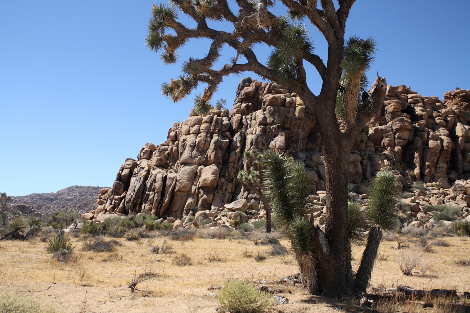
Near the entrance to Joshua Tree National
Park, the trees thrive.
Stores have barred windows and some unsavory characters roam the streets.  Twice when we walked to do laundry and to have dinner, scruffy looking men made comments. And when Andy walked last night, two teenage boys begged for money. He wanted to tell them to get a job or go back to school.  Wisely, he kept walking.  It’s sad what time has done to Barstow, a place I wouldn’t want to live.
When we left Barstow at 8:30 a.m., the temperature was already in the low 80’s. 
“It’s going to be another hot one,” said Andy.
Yesterday topped 100 degrees.  Today, October 1st, won’t be much under that.
As we drove south from Barstow, the valley spread out. Land for sale signs popped up: 20 acres for $64,500 toward the 6,000-foot elevation.  Farther down near a dry lake bed: 20 acres for $15,000.
“But who in their right mind would buy it?” said Andy.
I guess not too many from the looks of all the For Sale signs.
In Lucerne Valley we turned easterly on Route #247.  Even in the shadow of the foothills it was already 82 degrees.  But cirrus clouds blanketing the sun in a thin layer kept temperatures down.
A forest of Joshua trees stands tall at
the park entrance.
As we got closer to the foothills, Andy said, “This could be really pleasant in the winter.”
I agreed.  The foothills, rugged with layers of color and deep green canyons, cast interesting shadows.
“I’ll bet there are some beautiful spots deep within those hills,” said Andy.
But life along the road must be very difficult.  We saw house after house abandoned—deserted—vandalized—ruined.  Fate, not kind.  Shakiti Na Gai.
About 47 miles from Twenty-Nine Palms, the Joshua trees started popping up.  
Andy tries rock climbing at Quail Springs.
“It’s elevation,” said Andy.  “We are high enough here that they can grow.”
We had read that Joshua trees were named long ago because people thought it looked like they had their branches raised to the sky like Joshua praying in supplication to God.
Quality of life totally changed as we drove into the town of Yucca Valley and then Joshua Tree.
“It’s like a different world,” said Andy.  Roads were clean; houses, well maintained; land, generally cared for.  People here took pride in where they lived and in how they cared for their surroundings. 
“Except for the summer heat,” said Andy, “I’d like it here.”
“That’s a big except,” I told him.
At 11:00 a.m. it was 84 degrees, but a lovely breeze made the temperature pleasant.
As soon as we passed the park entrance, Joshua trees dominated as a forest.
“This is the pretty part of the Mohave,” said Andy.
The sign said, “Air Quality—good; Fire Danger—high.”  It was a pretty day.
Joshua trees grow slowly in the harsh
desert climate of quail Springs.
At Quail Springs two men with hard hats studied the ascent at an outcropping of monzo-granite—molten intrusion into the overlying Pinto Gneiss formation underground thousands of years ago.  They readied their ropes and adjusted harnesses to scale the huge boulders.  Some elderly Japanese tourists walked around the parking area, oohing and aahing, as Andy climbed one of the smaller boulders for a picture.
“I’m a tree hugger,” I joked, grabbing a smaller Joshua tree near a picnic site.
Joshua trees accent the unusual rock
formations of weathered monzo-
granite in the national park.
As we pulled out of the Quail Springs picnic area, Andy stopped again.  “There’s a good picture,” he said.  “I really like that tree.”
I could see it was going to be a long day from the looks of things.  The Joshua trees here were doing very well.
At Boy Scout Trailhead we walked in five minutes just before noon.  The whole trail was 7.7 miles one way.
Rock climbers' paradise this park has more than
500 identified climbing sites.
“Careful of the dagger yucca,” I warned, as Andy veered a little too close to the edge of the path.
Two more stops along the road meant more pictures.  Every direction offered gorgeous formations of tumbled mongo-granite and healthy Joshua trees.  Andy found a rusted bucket under one tree.  It had been here for a long time.I knew he love it here.  He even took the clean car on a dirt road pull-off.
“It doesn’t go very far,” he said.  “I’ll go really slow.”
The cracks and crevices of Hemingway Buttress provide
hand and foot holds for climbers.
Hemingway Buttress offers wonderful cracks and crevices for climbers. We walked to the foot of the formation and followed it along the base.  The interpretive sign said the park has more than 500 identified locations for climbing, many with whimsical names like Poodles are People Too and The Importance of Being Ernest.
Lots of people climbed Intersection Rock.  Some were at the very summit; others rested at the first major boulder top; still others watched and waited at the bottom.
Yucca and cactus grow
along the roads and trails.
Across the way, Rangers served a school group of third and fourth graders at tables at one of the picnic sites in Hidden Valley.
Their school bus was parked nearby.
It’s great to see a National Park being used for educational purposes. It’s even more special that maybe the children are being taught to care for the environment.
A healthy coyote crossed the road just ahead of us.  The climbers on Intersection Rock noticed him too.
Andy parked again.  “We’ll hike to Barker Dam.  That was a nice walk,” he said.
We grabbed our hats and headed out.  But nowhere did trail signs say Barker Dam. Ten minutes and one wrong turn in, Andy announced we were on the wrong trail, but we saw some lovely scenery and met a lizard with no tail.
Walking all around the formation, we look for the living oak
tree that gave this picnic area its name.
A little farther down the road was the pull-out for Barker Dam and Queen Valley Road.  Going 5 m.p.h., so as not to kick up dirt, we followed Queen Valley Road to Bighorn Pass Road.
“We’re behind the mountains that line the road,” said Andy.  These slopes actually looked volcanic and bunch grass grew plentifully.  Less prone to weathering, the interior had a totally different feel.
At Live Oak Picnic Area we looked for the anomaly in the desert.  There was no live oak tree that we could see.  We walked around the jumbled rocks and followed a few paths that seemed to have footprints but success in rooting out that illusive live oak was not to be.
Split Rock Loop Trail
includes different
plants and varied terrain. 
Split Rock Loop Trail out of the picnic area circled four or five large outcroppings of monzo-granite boulders as it wound in and out of the canyon and the wash.  Particularly enjoyable, the hike offered varied terrain and all kinds of desert plants.  We even saw a family of quail scurry off under some mesquite.  At the first loop back, I couldn’t imagine the two-mile estimate for distance was correct.  We were clearly heading back toward Split Rock after only ten minutes.  But the loop kept going far up the canyon before it circled back—undoubtedly a two-mile walk.  We kept a fast pace and hiked for 55 minutes.  Later Andy read that it was actually 2.3 miles.
From Keyes Point, views of the Salton Sea in the
distance are possible on a clear day.
By 4 p.m. we had driven up to Keyes Point, 5,185 feet.  From there we could see the Salton Sea in one direction and the smog of Los Angeles in the other.  A fire burned in the valley beyond; we saw the smoke rising in the distance. If I read the map correctly, the San Andreas Fault extended the length of the valley below along the Indio Hills.
At the end of the day we stopped in Sheep Pass to catch the 4:30 p.m. shadows on the rock outcropping.  At least a dozen young children grouped around tables with adults, and nearby six or eighty colorful tents had been pitched. It looked like a pre-school campout.
Leaving the park near Sheep Pass, we cross a high plateau. 
Temperatures climbed as we descended.  It was 93 degrees by the time we reached Twenty-Nine Palms, and the wind down the side of the mountain blasted the warm air.  But already the evening cool down hinted fall. I kept thinking—55 in suburban Chicago and a hurricane on the way back home.