Pages

Tuesday, November 30, 2010

Fire and Water on the Rocks


"They do a good job of cleaning the streets," noticed Andy as we walked back to the Flamingo from breakfast. All the sidewalks were wet. "Considering all the girlie circulars that are dropped, the hotels certainly fuss to keep up appearances." The roads, not so much.
We drove out to Valley of Fire, paid the admission fee of $10 to drive south on the highway, and meandered through the park. A big horn sheep grazed near the Beehives pullout.
"Do you remember camping here about 30 years ago?" asked Andy.
"Sure do," I told him. "It never went below 96 degrees all night, and we were in the tent, front and back flaps wide open, lying on top of our sleeping bags."
At Mouse's Tank, petroglyphs etched into the red sandstone combined with modern graffiti on the cliff face, all telling a story about man's desire to leave his mark on the world.
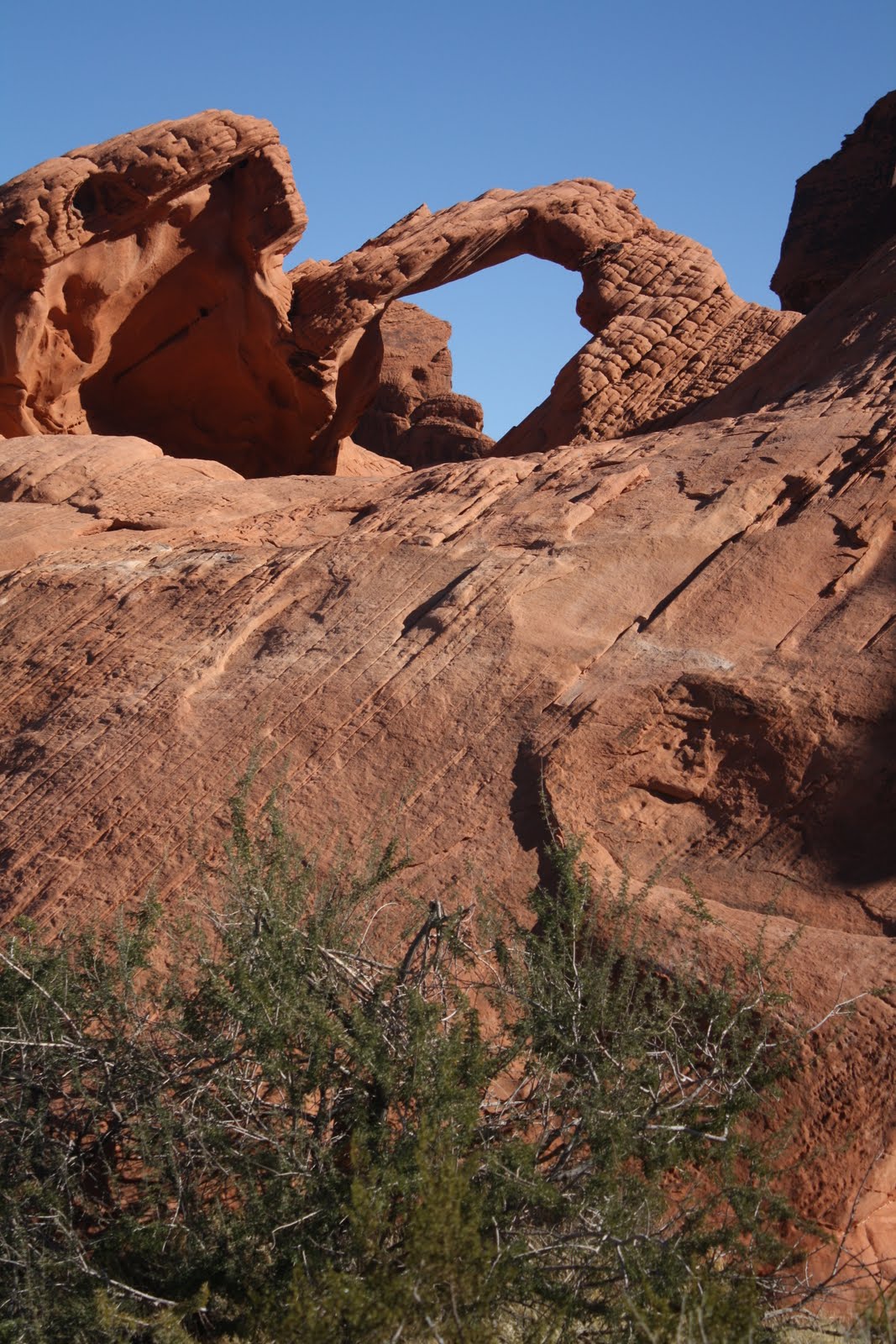
We stopped at Arch Rock for pictures. Wind burned our faces and fingers. Every turn gave a different perspective of the weathered sandstone. With the Aztec red against the blue sky, it's easy to understand how Valley of Fire got its name.
Petrified Trees and Balanced Rock afforded other perspectives, more focused ones, of this land of magnificent panoramas. Black desert varnish accented the rocks so they stood out even more against a cloudless sky, grey sage and green creosote bush. At Rainbow Vista some yellow wild flowers added another dimension. "We've never been in here before," said Andy. "The road has always been closed from the Visitor Center north. It looks a lot like southern Utah. Every direction you turn is a beautiful view." He was right. This ancient sea goes back to the age of the dinosaurs. The 1.25-mile trail at White Domes looped between spires of Aztec sandstone. Remnants of a rock wall from the movie set for Hacienda, one of about 12 films including Star Trek that were made here, were visible evidence from the past of the starring role this park has played in film.
"The summer does this no justice," said Andy. "It's so harsh then." Words like magnificent, incredible and rugged hardly seem powerful enough to describe the beauty painted here by nature, and our summer visits were so hot we didn't want to stay long. Now, in wintertime, Valley of Fire is a state park worthy of national attention.
Silica Dome overlooking Fire Canyon showed the contrasting layers of iron in the sandstone. An interpretive sign explained that Silica Dome, a unique geological feature, is an example of almost pure compressed sand. For more than four hours we walked sandstone cliffs, drove past intricately carved rocks, skirted around delicate spires and picked our way between boulders.
Each stop at places like Seven Sisters and Elephant Rock tweaked my imagination in a different way and made me proud that my country appreciates and preserves such places of natural beauty and wonder.
"This road [Lake Mead Boulevard] is directly attributable to the Economic Recovery Act," said Andy as we left Valley of Fire and followed Lake Mead. The roadside twinkled as we rounded bends and the sun hit silica. "They really did a nice job on the road," said Andy. As shadows crept down the hillsides, the desert hardly felt formidable. I remembered previous visits when this land appeared inhospitable and cruel in the sunlight.
True desert, the land surrounding Lake Mead, including Las Vegas, receives about four inches of rain a year. Three times I stopped to empty sand from my sneakers and socks.
"How do you do that?" complained Andy. "Did you never learn how to walk?"
The Redstone Trail at Lake Mead National Recreation Area featured a half-mile trail of terrain similar to Valley of Fire. "We did more than a half mile," I teased. "How many times did you lose the trail?"
"We did not get lost," Andy insisted, when we had climbed safely into Little Red. "I only looked for effective photo angles."
Layer upon layer of peaks stretched across our horizon in grey and black silhouettes, as we drove back to Las Vegas in the setting sun at 3:30 p.m. I looked out the car window at the fingers of erosion that stretched in long, dry rivulets down the hillsides. This land only gets four inches of rain a year. How much we take for granted, I thought. Plenty of water at the turn of a faucet and probably the highest water pressure in Vegas of anywhere on our trip so far.

"It's amazing to me that all this can be so close to such a massive city," said Andy.
"And so materialistic a city can exist so close to such natural wonders," I added.
"It's dark here by 4:30 p.m., because we are on the more eastern edge of the time zone," said Andy, as we drove back to town. Entering North Vegas, the sun dipped low near the horizon, and the neon signs blinked and glowed. It was only 4:00 p.m.
Two Dancing Water shows at the Bellagio, two volcano eruptions at Treasure Island, the lights on the Strip, the gondolas and the palazzo at the Venetian all provided an evening of free entertainment.

Monday, November 29, 2010

Colorful Las Vegas

We cruised along at 67 m.p.h. toward Las Vegas at 8:30 a.m. "Granted, the speed limit is 70 m.p.h., but everyone is passing me," said Andy. Not so, the other direction. Moving at the same speed but in a heavy stream, the vehicles were a mere car length apart going 70 m.p.h. "They're crazy drivers," said Andy. He commented about the tailgaters, a new pet peeve since we started this trip and a driving peculiarity he had not resented so much back East.
The weather channel alerted listeners to blizzards in Spokane and Salt Lake City, heavy fog in Seattle and storms around Cleveland. We had deep blue skies with a few white clouds lining mountain peaks on the horizon. "Cold and clear," Al Roker had predicted. He was right. He was also right about the 60 m.p.h. winds.
The road climbed to 4,120 feet. Covered with snow, Charleston Peak in Nevada stood out behind the treeless crags of the Clark Range. All around us the flat plateau supported only sage and creosote with an occasional spindly Joshua tree at the higher elevations. "It's really beautiful through here," said Andy. "The rugged mountains make gorgeous pictures." We pulled off Route #15 for photos. Every step threatened danger with broken bottles, glass and plastic litter covering the ground. At 4,700 feet yuccas intermingled with more Joshua trees. "I'll take the panoramic view any day here," I told Andy.
"Well," he said, "people can be slobs, and no one has cared for that exit off the highway. It's sad, but it shows we have a ways to go with environmental education."
Thanks to the help of Joy and Katherine and a pleasant half hour perusing fliers at the Nevada Welcome Center in Primm, we collected travel information for the area and lots of special deals for Las Vegas. When we tooled back on the road at 11:00 a.m., the traffic heading west crawled bumper to bumper. "That's Californians going back to work for Monday morning," said Andy. Fifteen miles later we zipped along, Andy holding the steering wheel with both hands to counter the cross wind gusts and steady Little Red, but traffic going the other way still inched bumper to bumper, with overheated vehicles parked, hoods up.
If after Thanksgiving to Christmas is the slowest time of year in Las Vegas, the city shows no dearth of visitors. Streets jammed in spite of the blustery weather (high of 45 degrees with 25 m.p.h. winds), lines waited to check in hotels and slot machines clicked away. Bundled up, we walked the streets, stopping at the attractions, checking out shows, picking up "deal" circulars. Indoors the Fire and Ice display at Caesar's Palace in the Shopping Forum drew the usual crowd. Later in the evening we returned for the free Bacchus animated show in the mall.

That was only after Treasure Island's Sirens cancelled due to extreme winds. Waiting outside for the performance, we missed the Mirage volcano eruption.
Window shopping in the Venetian, I pointed out all the luxuries I didn't need and many things I didn't want. The Bellagio conservatory disappointed more than a few people since Christmas decorating in progress kept visitors out, but we snapped pictures of some remaining harvest displays in the lobby from Thanksgiving. Gorgeous!
"I've never had a bad time in Vegas," said Andy. "And now we have already collected a few more colorful memories."

Saturday, November 27, 2010

It Doesn't Rain Here


Outside of Bakersfield on Route #58 the highway climbed a couple thousand feet into steeply rolling grass-covered hills. Trees dotted the crevices between hillocks. Then, like giant mole piles, the rounded peaks reached higher and steeper. More and more trees clustered and then dominated the hillsides.
When the highway reached 2,800 feet in elevation, we saw rock outcroppings and snow in the adjoining ranges. Puffy white streaks of clouds outlined the highest ridges. "It's so much prettier, and no one lives here," said Andy. "It is clearer up ahead, so in the valley the haze must be pollution. The air hits the mountains and just stops."
The town of Tehachapi, cradled in windmills at about 4,000 feet, had patches of white nearby. "They must get some cold winds up here through the pass to support the thousands of windmills," said Andy. Turning, turning, turning, the wind turbines lined every ridge. The giant mole hills pulsed with energy.
On the other side of the pass at 2,500 feet, the mole hills turned to cinder cones; Joshua trees replaced oaks, and the brown haze disappeared. Mist settled above the valley floor like a white sheet in the cold morning air.
"Is this the Mojave?" I asked Andy.
We passed the exit for Edwards Air Force Base. "Yes, and this is where the shuttle lands when weather prohibits touchdown in Florida," said Andy.

A sign at Harper Lake Road said, "Wildlife viewing area." We followed the pavement six miles toward the dried out lake bed until it changed to washboard dirt. "That's it," said Andy, turning around. But heading back out past abandoned houses, a motel and a general store, we checked out a side road. There in the middle of the high desert of sage and creosote bush was a SEGS plant, with thousands of solar panels to gather the energy from the sun for heating water to steam to create electricity.
"I've read about this," said Andy. "At least they are trying to develop alternative sources of energy. I give them credit, although it's still very expensive."
Everything along old California Route #58 was abandoned, from the truck repair garage to the outdoor movie theater to motels and private homes. What a decrepit result of progress!
"Are you having heart failure?" Andy asked as we pulled out of Rainbow Basin. We had bushwhacked with only a road sign for an hour.
In truth, I held my breath. I really thought our luck had run out and this is where we would be stuck. The Canyon Loop, actually just a dry wash, had soccer-ball size rocks and eight-inch deep ruts. Like it or not, we couldn't turn around.
"Easily, enough to destroy the undercarriage," said Andy about the road conditions.
But Canyon Loop was one-way and one-car-width narrow in the most washed-out areas. We stopped to let the engine cool more than once. Andy breathed a sigh of relief when two other empty, parked vehicles showed us people had gone before. Unfortunately, one of the two was four-wheel drive. I kept one eye on the clouds. Any rain meant no hope of getting out ourselves. "Don't be silly," said Andy. "It doesn't rain here." But I saw his hand shaking.

Friday, November 26, 2010

Starting Back


San Luis Obispo hit a record low last night at 31 degrees, but this morning the flowers weren't shriveled. "I think the humidity and the short duration of the cold snap protected them," said Andy. "It probably turns coldest just before sunrise, and then warms quickly the instant the sun comes up."
Frost covered the fields as we headed east through Santa Margarita at 8:15 a.m. "They were in the low 20's here last night," said Andy. "No tempering ocean this far inland." The frost sparkled on range grass as the sun climbed a little higher. Around one bend, seven wild female turkeys darted across the road in front of us. Lucky ducks, I thought. Around another bend, children played in six inches of snow at one house. Adults in small groups of twos and three watched the "Christmas at Thanksgiving" fun. I wondered if the family had won a "let it snow" contest.
Carrizo National Monument, a 3,000 acre prehistoric lake bed, protects more rare and endangered vertebrates, like the giant kangaroo rat and the San Joaquin kit fox, than any other place in California. Dry now, the alkali lake is home to migratory birds in the spring.
With no natural outlet, the water from rain and runoff of the Temblor Mountains evaporates, leaving sodium sulfate and carbonate salts. We climbed to Soda Lake Overlook and walked out to the lake to follow the 816-foot boardwalk. A meadowlark called out, the zippers on my pouch jingled with each step, and our heels clicked on the plastic boardwalk, made of recycled milk jugs. Those were the only sounds in the place of solitude and loneliness. "This is one of the sites that Bill Clinton protected in the final day or two of his administration," said Andy. "The San Andreas Fault runs through this valley."
Bushwhacking on a dirt road took us to Wallace Creek Trail. Andy rolled Little Red along the washboard in second gear.
"I know the sign described a trail to the San Andreas Fault here," he kept insisting. "Seven Mile Road to Elkhorn Road."
"Seven Mile Road was dirt too," I reminded him. But sure enough, eleven miles later, a pullout with one interpretive sign explained how the San Andreas Fault moves the land in this area. In 3,800 years Wallace Creek has shifted about a football field. We stood on the north bank. "If you stay here for ten million years," I told Andy, "you will be within walking distance of the Golden Gate Bridge."
"Thanks," he said. We climbed up the ridge and followed the trail to where the Fault disappeared onto the hill.
"Look!" yelled Andy, "I'm going north and south at the same time." Thank goodness he wasn't. But what God forsaken country! The shifting of the San Andreas certainly won't do any damage here.
Oil pumps stood silent around McKittrich. A brown haze clung to the mountains and filled the valley. Then over one hill we spotted a helicopter with a large black object suspended. "It looks like a cow," said Andy, "but who would spend that on one cow? It's probably something to do with oil production." Over another hill we saw pilings from a mine. Desolate, bleak, treeless plain opened before us. "My gut feeling is that the brown cloud is an inversion," said Andy. "If not, the air pollution is terrible."
We crossed a California aqueduct and the desolation immediately disappeared. Field after field of fruit trees and plowed earth lined both sides of the road. "This is Central Valley," said Andy, "probably the most productive in the country, and it's those mountains we just went over that protect it." Route #58 passed orange groves, the bright fruit still on a few trees by the road, and cotton fields; white residue clung to the weeds and littered the ground.
At the Bakersfield holiday lots, decorated with red, green and white flags, Hispanic workers unloaded evergreen trees.
Kern River Parkway Park in Bakersfield featured the last bronze sculpture of world renowned artist Victor Salmones, Cancer--There's Hope. It has been said that Salmones, born in Mexico City, 1937-1989, "captured emotion in motion." The positive vibes felt good.
Brown haze hid the mountains in the distance. "It could be a lot of stuff," said Andy, "There's a refinery over there, plowed fields outside of town, fertilizer, lots of cars in a city of more than 330,000 people, oil wells and industry, a weather inversion, any and all of the above."
"But it's the first we have seen of such overriding air pollution," I told him.

Thursday, November 25, 2010

Thanks So Much

This morning I'm grateful for fresh, crisp air and beautiful sunny skies.
"I'll bet the farmers watered heavily last night," said Andy. "Ice doesn't kill the plants, and with 26-degree temperatures, they had a killer freeze last night."
We drove south toward Mission Santa Ines at 9:00 a.m., squinting in the blinding sun. The countryside warmed, and traffic kept moving on Route #101. Mission bells on high poles marked the route Father Junipera Serra followed in the 1500's to establish the string of missions in what is now California, spread his faith and claim the land for Spain.
Everywhere along the road yellowed fields of grapes spread for miles. "That's why you can buy wine here at Walmart for $1.97 a bottle," said Andy. As far as we could see, grapevines lined the rolling slopes in harvest colors. "Now there is overabundance, and California, the largest wine-producing area in the country, has lots of competition from other states."
"It's getting drier," noticed Andy as we drove east on the Chumash Highway, Route #154, toward Solvang, the site of the 1804 Mission Santa Ines. Bilingual mass, celebrated at 10:00 a.m., filled the sanctuary with music. We walked the grounds: a cemetery that was the burial site for 2,000 Christianized Chumash Indians and 500 early settlers; luxuriant gardens with cacti, succulents, palms and flowers of all kinds; an expansive rose garden, many still in bloom, lined by olive trees, still bearing fruit; a fenced-off lavanderia, preserving the original adobe walls, where converted Indians did their laundry and bathed so many years ago. Signs explained how Spanish friars taught nomadic Indians how to grow corn, wheat, peas and beans and how to raise animals for food instead of following wandering herds.
The missions altered lifestyle and settled California when it was still part of Mexico.
Purisima, built in 1820, functions as a California State Park. This mission was abandoned by the Catholic Church in the mid-1800's after Abraham Lincoln deeded mission property back to the Church in 1862. Then most Spanish missions had been stripped and were in total disrepair.
The Civilian Conservation Corps (CCC) totally refurbished Mission Purisima during the Depression for its value as living history. Pigs grunted in the pig pen; sheep, donkeys and goats grazed in the fenced-in yard; and turkeys, lucky to be gobbling on Thanksgiving Day, pecked in their enclosure. Although the park was closed, at least 100 people ducked under the gatepost and strolled the grounds. Andy took off his sweatshirt and tied it around his waist. What a wonderful way to spend Thanksgiving Day!
At Ocean Dunes State Vehicle Recreation Area, the only beach in California that allows vehicular traffic, I waded ankle deep in the Pacific Ocean. I couldn't roll my pants legs any higher. That's probably a good thing, since the water was bitterly cold.
We stopped again at Pismo State Beach Monarch Grove to marvel about the delicate insects floating between eucalyptus and pine trees. The docent said more than a thousand visitors had walked the Grove today.
More people strolled along the shore on Pismo Beach, snapping pictures, walking dogs, digging in the sand, simply enjoying the clear skies and bright sun. A few brave young ones even dared the water. Before Andy and I headed for Thanksgiving dinner, we read how Pismo Beach got its name. Pismo, the Chumash Indian word for a sticky thick black oil, seeped from a fissure out at sea and ended up in globs on the beach. The Indians used the tar-like oil to seal their canoes. In every sense, beach tar at Pismo made life easier and better for them. We didn't notice any pismo on the beach. But after a lovely afternoon, we gave thanks, like the Chumash Indians must have done, for this beautiful location and the inspiration it provided.

Monarchs Rule


We stopped again at the Pismo State Beach Monarch Grove. At 2:00 p.m. Docent Ernie delivered a butterfly talk. He explained that no monarch crosses the Rocky Mountains, and all eastern monarchs winter in Mexico. Western monarchs winter at 300 sites in California. Four of those are major sites, usually with Pismo Grove as the largest. This year Pismo is the winter home to about 16,000 butterflies. Ernie said the number varies yearly based on the milkweed available, from a low of about 15,000 insects since they started tallying to a high of more than 200,000. The past four years in California have been dry ones, so less milkweed as food for caterpillars means fewer monarchs.
"The count must be unscientific," said Andy."
Ernie explained that a professor and students count the number of clusters in the cold early morning and then count how many individuals cling to an accessible branch in one cluster. That is multiplied by the approximate number of clusters in the reserve at any given time. Butterflies cluster at night to keep warm, since they can't fly when temperatures dip below 55 degrees.
"Yup," said Andy, "highly unscientific."
We also learned that the monarchs we watched would live in Pismo Grove without eating until mid-February. Then the males, those with two small black dots on the lower wings, would know it was Valentine's Day and would look for a mate. When pairs come together, they fall to the ground in the Grove. Then the male carries the female to the tops of the trees. "It sort of sounds like a honeymoon," I said to Andy.
By March 1, pregnant females flutter north about 200 miles, looking for milkweed plants. They lay eggs smaller than the size of pin heads on the underside of milkweed leaves before they die. The eggs hatch and the caterpillars eat for nine days, more than 27 times their body weight, shedding their skin as they grow. With the last shedding, each larva attaches itself under a solid surface, wraps itself into a "J" shape and forms a chrysalis. What emerges is an adult butterfly that heads north another 200-300 miles.
Five or six generations of insects later, the adult that will winter in Pismo arrives at the northernmost range, like Vancouver or Victoria on the West Coast. Suddenly in late August or September that monarch knows to fill up on nectar for the 1,000-1,600 mile flight back to Pismo Beach, arriving by early November for the winter.
"So the butterflies at Pismo do nothing all winter," said Ernie. "Their job is to survive so that five or six generations hence there will be other monarchs that can fly back to Pismo."

Wednesday, November 24, 2010

Celebrating Life


On the day before Thanksgiving we are as far west as this trip takes us. Slightly inland tonight, we stay in San Luis Obispo, 72 days away from home.
A frost last night turned parts of the garden and lawn at Cambria Pines white, and ice coated Little Red in a frozen film.
At 8:30 a.m. we again climbed Black Hill, this time for a sunny view of the marshes and Morro Rock from the top of the 665-foot cinder cone.
Elfin Forest looked different in the sunlight, as well. We walked the pygmy oak boardwalk that we had jogged yesterday in the rain, identifying lavender, black sage, coyote bush and poison oak along the way.
The birds of prey perched on the telephone wires along the road are kestrels. They seem to thrive in the open fields near the coastline.
A one-mile hike on Oak View Trail at the Los Osos Oaks State Preserve wound through dense undergrowth and a stand of 200-year old coastal oaks. "According to the folders, there is a planned hike in this area almost every day," said Andy. Little Red was alone in the parking lot, but the holiday traffic on the highway picked up considerably.
At Harford Pier #3 the pelicans celebrated Thanksgiving a day early, as a colony of harbor seals drove a school of sardines into the bay where a hundred small sail boats had anchored.
On the shoreline the RV park posted "No Vacancy," and RV campers filled every spot. I wonder if they cook turkey for Thanksgiving dinner.
We found the Pismo State Beach Monarch Butterfly Grove before the GPS directed us there. Winters are warm enough at Pismo Beach to support the wintering of monarchs. We had better not tell them that predictions for tonight may drop as low as 26 degrees. As many as 20,000 monarchs make the Pismo acre of eucalyptus and pine trees their home in the winter months before they and their descendants head back north. Some travel up to 265 miles in a day. "The eastern monarchs have the farthest to fly," said Andy, reading the signs. "They go all the way to Mexico, but that is where so much of their habitat is being destroyed." Visitors stepped carefully, gazing upwards as monarchs fluttered over us.
A travel brochure advertised Pismo Beach pier as 1,200 feet long and one of the highlights of the town. We walked to the end, watching a plethora of bundled out-of-town tourists line up for clams and oysters on the adjacent boardwalk. Fishermen dropped lines far down into the water, and surfers paddled in the waves below us. "I got one," called out an older lady, pulling on her line.
Her husband dashed to her aid. "Not bad," he said, unhooking what looked to me like a 10-inch perch.
"Dinner," I joked.
"No kidding," they agreed. The bright sun compensated for the wind off the water, but with temperatures in the low 50's, my hooded jacket felt good.
The Mission of San Luis Obispo de Tolosa, built in 1772, combined manicured gardens, grape arbors and a barbecue patio with a beautifully maintained parish church. Next door to a city park called Mission Plaza, the grounds were extensive. At the park entrance, a worker painted white edging on a red Santa Claus House. Other than the harvest colors inside the chapel, that was the only clue that tomorrow is Thanksgiving. Did I experience pangs of homesickness, or was it just selfish feelings about our dearth of Thanksgiving dinner plans?

Tuesday, November 23, 2010

Timing Is Everything


If timing is everything, we planned correctly. Rain moved in overnight and socked Cambria and the coastline in with misting, dripping, drizzling gray clouds. But we had Hearst Castle tickets for Tour #2 of "The Enchanted Hill" at 10:20 a.m. This tour, mostly indoors, featured the main house upstairs guest rooms and sitting rooms, the libraries, the Hearst private quarters, the downstairs kitchens, and the indoor swimming pool.
Keeping to a strict timing schedule, Guide Muna escorted us up and down the circular staircases that twisted around corners of the mansion, and she pointed out intricately carved and painted European ceilings that William Randolph Hearst had purchased from art dealers in New York.
Answering questions and offering insights, she explained, "Hearst collected art, especially Italian and Spanish pieces from the 16th and 17th centuries. But you have to remember, he was born in 1863, so his tastes were more classical, the Mediterranean revival style." Earning about $50,000 a day from his corporations, Hearst could afford to be selective. "Most of his art is authentic," she said, "but see that one huge Chinese jar over there?" She pointed to a four-foot porcelain vase in one window of the main library. "That one is only 200 years old. He got taken on that purchase."
The father of five boys, including the youngest a set of twins, Hearst loved San Simeon where he had camped as a child and could wander outdoors. He was most proud of his books, as evidenced by the private library, and his collections of art; and his favorite pastimes were riding, playing tennis and swimming laps.
"He was a private man," said Guide Muna, "not demonstrative, but he loved having guests around him." As a consequence, he kept asking architect Julia Morgan to convert every inch of the concrete and steel mansion into guest suites, and often on weekends in the 1930's he hosted 30-50 guests. "As an only child, he just liked people," she said.
Muna also explained how money was rarely an issue for Hearst. His father, a self-made millionaire miner, one of few who actually made money during the Gold Rush, initially purchased ranch property. Hearst expanded the holdings to 250,000 acres.
After the tour I asked if any of the five boys were still alive. The receptionist at the front desk said, "No, the last one, one of the twins and Patty Hearst's father, died in 2000."
"What did you think was the most interesting?" I asked Andy as we headed for the car.
He told me, "Well, first Hearst married a dance hall girl against his parent's wishes and then years later when they separated, he fell in love with another dancer." We chuckled about the details. "I also listened to the information about architects Stanford White and Morgan. Did you hear the guide say Morgan's philosophy was, 'Never turn down a commission, because it could always lead to something else'? I thought that was interesting."
"I liked Hearst's interest in animals," I told Andy. "Imagine having polar bears in your backyard in California and caring for them properly!"
The bus driver pointed out a Barbary sheep, called an aoudad, posing on a hilltop as we descended. There are still zebras, Roosevelt elk, tahr goats, sambar deer and wild pigs on the grounds of the 68,000-acre working ranch.
"I guess what California just purchased," mused Andy, "was a conservation easement. It means the ranch operates as is in perpetuity. The land cannot be developed, except for the limited acreage belonging to the Hearst grandchildren. It's an easy method of preservation for California, but it also doesn't allow for improvements as a park."
Back at Morro Rock, we caught a break in the storm. "Quick," said Andy. "You can get pictures with and without sun glinting off the volcanic plug." It made for an interesting contrast.
Black Hill, home to coyote and bobcat, climbed to 660 feet. It provided us a view of the adjacent extinct volcano, as well as Morro Bay and Morro Rock. The sun came out just as we reached the car, but we didn't get rained on.
At Elfin Forest, migratory spring home of the Chumash Indians, a boardwalk revealed rare pygmy oak trees. But our luck ran out a quarter mile from the car, as the rain came back in off the marsh. Wouldn't you know, blue sky patches followed ten minutes behind, but it was long enough to get rather wet. Thank goodness Little Red has a good heater!
Back in Cambria, skies cleared and winds out of the northwest picked up. We walked the Fiscalini Ranch Trail, literally holding our hoods up and keeping our hands over our ears. Just steadying the camera for a picture took effort against the sustained 25 m.p.h. onslaught. Even the seagulls, resting on the rocks, had trouble in the air and generally flew backwards when they did take flight. Sunset was just as windy and just as striking.

Monday, November 22, 2010

Stepping Carefully

"Hands down, this is the time of year to travel," said Andy, as we set out from Cambria for a hike at a pullout 20 miles north. It rained last night in Cambria, and there were still clouds in the mountains, but California Route #1, originally completed in 1937 and named Theodore Roosevelt Highway, was in the clear.
We had Silver Creek Falls all to ourselves. Huge boulders at the bottom of a steep, slippery slope concealed three major falls and a few smaller ones. We picked our way along the unmarked trail, stepping gingerly over the wet leaves and oak roots and around boulders and poison oak patches. The reward was a hidden cove with cascades tumbling down the cliff face a quarter mile from the road.

We stopped once more at Elephant Seal Cove. Even though many animals slept, lots more bobbed in the water and challenged each other. Guide Paul said, "This colony started when 16 came ashore on Thanksgiving Day 20 years ago. Last year we recorded 4,200 births on this beach to a colony of 17,000. The pup survival rate is about 40%, and we know they come back to the beach of their birth, just like the salmon, so here the species is doing well."
"I read they eat mostly squid," said Andy.
"Yes, that and small fish. They are deep water feeders," answered Paul.
"Squid," said Andy, grinning. "They must be Italian. They love calamari."
On the other side of the cove, Guide Erlene passed out E-Seal News fliers. "Internet said 19 came ashore originally, but regardless whether it was 16 or 19, they are surviving," she agreed, "and since they aren't needed for oil now, the prognosis for the species is good."
We stopped at Hearst Castle to check out the tours and book our tickets for tomorrow.
Then we walked Moonstone Beach in Cambria, first along the boardwalk and then picking careful steps on the rocks between tidal pools as the waves receded. Andy spotted a large starfish, probably eight inches in diameter, tucked under a rock crevice.
In another pool washed by sea water, several sea urchins clung to the sides of the rocks. Snails moved slowly along the bottom and mussel shells floated up and down as gentle waves lapped in. Rich in life, the shore offered new discoveries at each careful step.
Farther south, Morro Rock, a volcanic plug, identifies the town of Morro Bay from miles away. Connected to the mainland by a man-made causeway, the monolith has been a historical landmark since the Portola Expedition of 1580 and an ecological preserve as a nesting place for the endangered peregrine falcon.

We browsed in some shops along Main Street in town, walked the sand beach and scaled the uneven boulders of the bayside groin. Strenuous rock hopping along the top of the groin demanded some serious attention and a good sense of balance for me, but Andy's firm hand kept me moving and prevented any slips. It even gave a different perspective for photography, and we didn't even get wet!
With houses hugging the volcanic slopes and streets lined with palm trees, Morro Bay looks like a Mediterranean village.
Cambria Pine Lodge opened the holiday season with a garden light show after dark. Thousands of tiny colored Christmas lights decorated shapes of animals, people, trees and archways throughout the grounds for a beautiful nighttime spectacle.