 Sea gulls in Beaufort dotted a cut field like clumps of snow. We turned in to a new development; the plot plan for eight 10-acre lots was posted at the entrance. "Those go right out into the marsh," said Andy. We drove in. "The lots must be nine acres of wetlands with one buildable acre per plot, but even here by the road is standing water." The puddles had a crystallized glaze of ice on the surface. "I saw this development in a land and homes book last night. They were selling for $200,000 each. How can they accommodate a septic system?
They certainly don't have city sewers here." He rambled on to himself. "I think it's pretty with the trees and marsh, but Connecticut builders would never get permits for land that's only two feet above sea level. Even with just concrete slabs, there isn't enough land above water to build."

Otway... Smyrna... Williston.... I followed the map so we wouldn't miss any turns for the early ferry... Davis.. Stacy... Sealevel. We wound through small towns and across lowland marsh on the way to Cedar Island dock for the two-and-a-half hour boat trip to Ocracoke, my $15.00 romantic Valentines cruise.
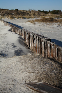
At the dock, I snapped the same picture of the old pilings and sand dunes that I had taken yesterday. I liked the morning lighting even better.
At the dock, I snapped the same picture of the old pilings and sand dunes that I had taken yesterday. I liked the morning lighting even better.
 At 9:45 a.m. the ferry pulled in. Sixteen vehicles disembarked, trucks with fishing gear, vans, construction vehicles. "Everything on Ocracoke has to be ferried in. No bridges. It's a true island," said Andy. A deckhand flagged us on board. "They'll leave right on time," said Andy. "Better than the airlines."
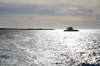
Within minutes no land was in sight. A cold wind whipped up little waves. I wobbled forward, trying to take pictures. One older couple dozed, sitting up in the front seat of a pickup truck. Several Hispanic workers sat in the cabin drinking coffee and joking in noisy Spanish.
"M/V Cedar Island, 1994" said Andy, reading the plaque in the lounge.

"Motor Vehicle?" I asked.
"No, Probably Marine Vessel," he answered.
Since the Visitor Center closed for lunch, we drove leisurely around town. The fixed light of Ocracoke Lighthouse, built in 1823, warned ships of land for 14 nautical miles in 360 degrees. The oldest continuously operating lighthouse in North Carolina and second oldest in the U.S., the tower is five feet thick at the base and 65 feet tall.
Since the Visitor Center closed for lunch, we drove leisurely around town. The fixed light of Ocracoke Lighthouse, built in 1823, warned ships of land for 14 nautical miles in 360 degrees. The oldest continuously operating lighthouse in North Carolina and second oldest in the U.S., the tower is five feet thick at the base and 65 feet tall.
The Hammock Hills Nature Trail crisscrossed a pine forest to the salt marsh on the other side of Ocracoke Island. Some trees, so well established on the old dunes, grew 40 feet tall on this 12-mile long barrier island.
 "Six inches of snow! Here!" exclaimed the clerk in the Visitor Center when it opened after lunch. "We get a dusting now and then, but this year has been incredible. We're an island. We walk anyway, but with six inches on the ground, every road turned into a sheet of ice. We have no plowing equipment."
"The kids must have loved it though," I said.
"Oh Wow! They surely did," she said. "And the oddest part was the mainland got nothing. The storm came right up over the water. They had an earlier snow and we didn't get any."
Andy and I strolled the beach at Pony Pens, collecting sea shells, walking the pine boardwalk and watching the Ocracoke ponies, descendants of Spanish mustangs, graze in a huge penned field.
 "The 40-minute ferry to Hatteras runs on the hour from the other end of the island," said Andy. We couldn't have timed it better. Just as the flagman waved us on board Frisco, the deckhand closed the stern gate and blocked Little Red. This time salt spray splattered the car. I licked my lips and tasted the air. Gulls followed us and a pelican swooped in a large circle from starboard to port. "He's really hauling," said Andy about the ferry operator. Off to our starboard side a sand bar attracted thousands of cormorants. "See the water breaking on the shoals?" asked Andy, pointing to one end of the sand bar.
  "The birds have good fishing there, because it's the entrance to the bay."
The boat made its way back and forth between buoys, avoiding sand bars and following the channels. Little Red, covered with salt spray, looked like we had driven through mud puddles.
The wind picked up again with each turn of direction. "It's the cold front coming through," said Andy. And as the sun dipped toward the horizon, the temperatures dropped.

 Threatened by the Atlantic Ocean, Hatteras Lighthouse, built in 1872, was moved 2,900 feet farther inland in 1999. The tallest brick lighthouse in the world at 198.5 feet, Hatteras Lighthouse flashed every seven and a half seconds to warn ships up to 19 nautical miles away of treacherous waters off the coast of North Carolina's Outer Banks. I watched and counted to seven and...
Often called Graveyard of the Atlantic, the area meant destruction for more than 600 ships, victims of shallow shoals, storms and war. We identified Diamond Shoals, a bank of shifting sand ridges hidden beneath a turbulent sea right off the cape, that repeatedly threatens safe passage.
 The Hatteras Lighthouse Museum described actions of the German submarines that harassed unescorted ships here during World War II. So many Allied tankers and cargo vessels went down that the waters earned another nickname--Torpedo Junction.

 Threatened by the Atlantic Ocean, Hatteras Lighthouse, built in 1872, was moved 2,900 feet farther inland in 1999. The tallest brick lighthouse in the world at 198.5 feet, Hatteras Lighthouse flashed every seven and a half seconds to warn ships up to 19 nautical miles away of treacherous waters off the coast of North Carolina's Outer Banks. I watched and counted to seven and...
Often called Graveyard of the Atlantic, the area meant destruction for more than 600 ships, victims of shallow shoals, storms and war. We identified Diamond Shoals, a bank of shifting sand ridges hidden beneath a turbulent sea right off the cape, that repeatedly threatens safe passage.
 The Hatteras Lighthouse Museum described actions of the German submarines that harassed unescorted ships here during World War II. So many Allied tankers and cargo vessels went down that the waters earned another nickname--Torpedo Junction.
Not far away, two British sailors, sunk by Germans during the war, had been laid to rest.
The Hatteras Lighthouse warns sailors today; now few ships wreck. But storms still uncover the ruins of old wrecks along the beaches. We went back to the lighthouse beach to see its original location. The wind lashed cruelly, and waves crashed against the metal barriers that protect the dunes and beach. But 2,900 feet away, silhouetted against the sunset, flashed the light... faithfully, every seven and a half seconds.
No comments:
Post a Comment