 "I never thought they had this much snow up here," said Andy. Route #377 to Chilili was a snow-packed sheet of ice. "This is when you see the difference in taxes." The road was heavily traveled from 7,300 feet into Albuquerque, but it wasn't sanded at all. The brilliant morning sun softened the surface, but clouds shrouded the highest peaks at a blustery 16 degrees, and 25 m.p.h. winds shook powdery white from the cedars at the 7,400-foot elevation. Then we headed down the other side.
 Escohosa at the top had No Trespassing signs and Cattle on Road signs on both sides. Going down meant aiming Little Red in the center of the road and keeping the speed at 20 m.p.h. so we didn't spin into a ditch or go off the side. We could see the valley 15 miles below us. "I can tell you one thing," said Andy, holding tight to the steering wheel, "I'm glad for the sun and for front wheel drive."
"That's two," I said, "and I told you Little Red would handle well in the snow."
 "But the sun here helps," said Andy. "This will be a sheet of ice tonight." The morning news had said the whole city of Santa Fe had only five plows. Plowing Route #377 would do nothing because the snow was already packed down hard.
Near Route #55 toward the valley a thousand feet down, the road cleared, but the wind picked up. Around Tajique and Torreon we passed garlanded crosses. "Someone died on those bends," I said.
"I read an article last night," commented Andy, "that said American Indian males have a very high incidence of depression and suicide in general." The roadside crosses probably reflected excessive speed or drunken driving.
 It was mighty cold at Quarai Ruins, a mile west of Route #55 and once the home of about 500 people. Ranger Murt welcomed us, the first visitors to actually sign in for two days. "Be careful," he warned. "It's very slippery." Ruins from the Franciscan settlement of 1630 to 1680 included the three-story walls of the church. Anasazis occupied the area for 400 to 600 years before the Spanish, and, for a time, the Indians lived in harmony with the newcomers. But increasing demands by the Spanish government for products and increasing intolerance of Indian rituals, especially the kachina dances, fostered discontent, secretism and revolt among the native peoples during the era of the Spanish Inquisition.
 It was mighty cold at Quarai Ruins, a mile west of Route #55 and once the home of about 500 people. Ranger Murt welcomed us, the first visitors to actually sign in for two days. "Be careful," he warned. "It's very slippery." Ruins from the Franciscan settlement of 1630 to 1680 included the three-story walls of the church. Anasazis occupied the area for 400 to 600 years before the Spanish, and, for a time, the Indians lived in harmony with the newcomers. But increasing demands by the Spanish government for products and increasing intolerance of Indian rituals, especially the kachina dances, fostered discontent, secretism and revolt among the native peoples during the era of the Spanish Inquisition.
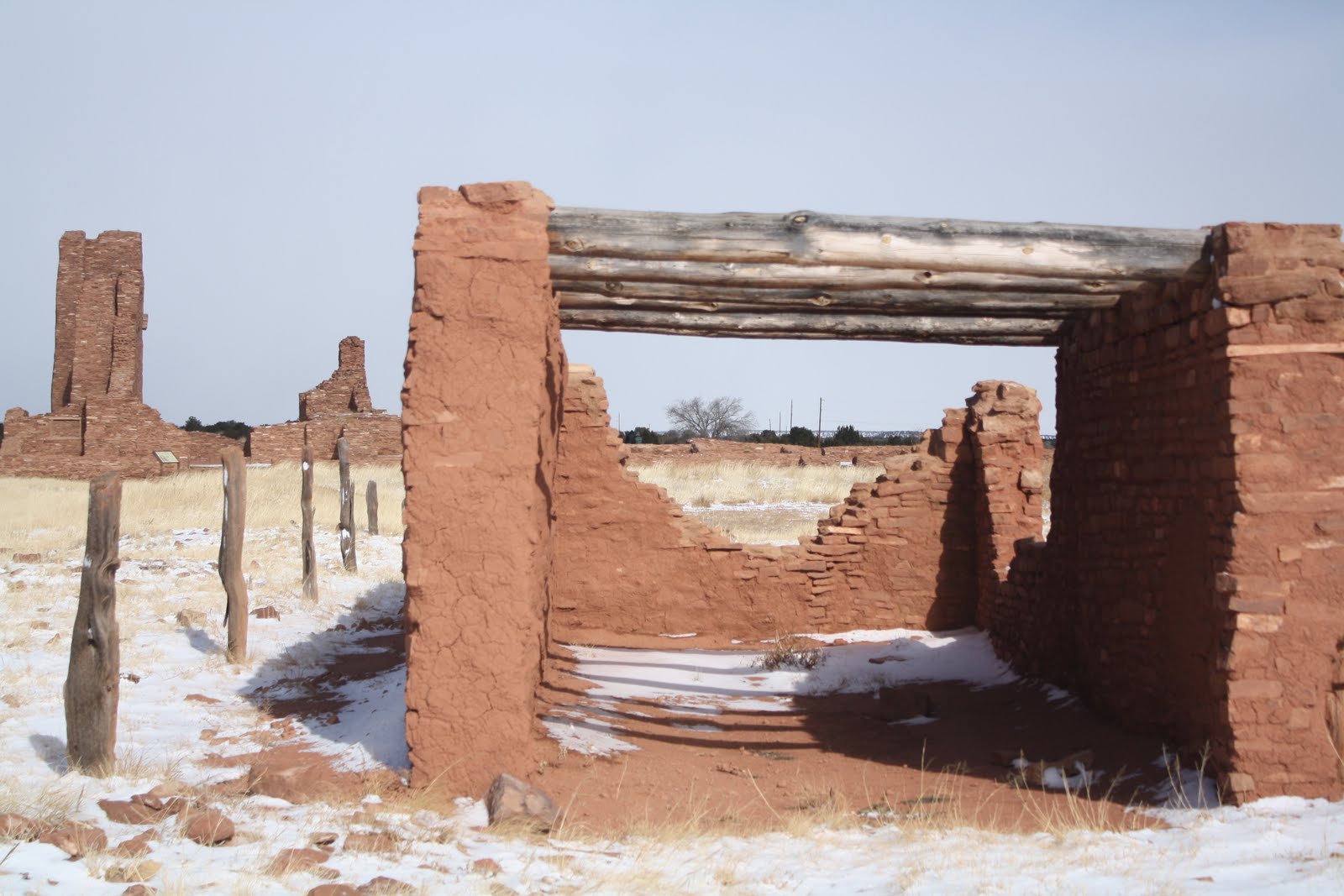

"It's the wind," said Ranger Jerry at Mission of San Gregorio de Abo. He and Andy chatted about days off and life as a ranger while I looked around the gift shop. "The wind whips across here, which makes it colder," he said.
Abo, a pottery center for the Mogollon people for as much as 700 years, was inhabited for probably 7,000 years and preceded by nomadic Indians who may have arrived as early as 20,000 years ago. Once the Spanish settled in 1621, the settlement died within 50 years. Threats from Apaches to the North in the 1660's didn't help, nor did widespread epidemics of disease brought by Spanish. The natives had little resistance to European disease, and droughts and famine of the 1660's and early 1670's made starvation a reality, as well. Battered by disasters, the 1,500 people of Abo left between 1672 and 1678, but in the interim two churches had been constructed, the first by 1629 and later the renovated three-story building with a sophisticated buttressed roof.

 An army expedition led by Major J.H. Carleton discovered the ruins in 1853 and described them as "standing there in solitude with an aspect of sadness and gloom... the cold wind... appeared to roar and howl through the roofless pile like an angry demon." Things haven't changed all that much.
The sign in Rio del Oreo said -228 degrees F. The ruins had not been quite that cold. We stopped along the road a couple times for pictures of blue sky breaking through.
 Ranger Dave at Petroglyph National Monument Visitor Center in the shadow of Sandia Peak warned us that they were closing early, so gates to the main area would lock at 3 p.m. The two northern canyons operated in conjunction with the city would be open until 5 p.m.
Boca Negra Canyon petroglyphs included three short trails in the lower section, probably a total of a mile, and a longer mile trail in the upper section. Here and there we picked out drawings pecked into the desert varnish on the lava. Famous for human-like figures, animals and geometric shapes, the ancient artisans completed most of their decorating around 1300 A.D. "They are all so different," said Andy.

 "Well, it was an artist colony," I suggested. "Different artists have different styles."
He laughed.
The wind picked up when we found Piedras Marcadas Canyon a couple miles northeast. There, nestled in a residential section, the trail followed an ancient ridge of lava for a mile and a half. Six major areas of side trails identified petroglyph collections. Bundled in our warmest jackets and hats, we traversed the whole stretch, the side routes and back to Little Red by 4:45 p.m. The car was a welcome sight as the sun went down and temperatures plummeted. The last night of the year was a cold one in Albuquerque, New Mexico. Predicted low was 9 degrees.
No comments:
Post a Comment