Pages

Monday, September 26, 2016

RETIREMENT TRIP #7
Mountains of Volcanoes
                                                                      We’ve already been as far west as we are going on this trip and today we’ll be as far south as we’re going to go… once we reach Chester, California.  At 9:00 a.m. the temperature had already surpassed 82 degrees.  It was going to be a warm one.
“I’m tired of the heat,” complained the desk clerk when Andy checked out.  “I’m ready for summer to end.”
Andy is dwarfed by the 300-ton
Hot Rock from the Lassen
Volcano eruption of 1915.
“It will be cooler for us,” Andy told me in the car.  “Lassen is much higher in elevation.”
Temperature drops three to five degrees every 1,000-foot rise in elevation.  The highway climbed consistently as we headed south.
Hot Rock was ejected from the volcano core on May 19, 1915, when Lassen erupted.  Local resident B.F. Loomis said this 300-ton piece of dacite lava was still sizzling in water 40 hours after being shot from the volcano five miles away.
The mud flows from 1915 are apparent in this photograph
of Lassen Volcano that shows the side of the mountain
blown out by the force of the explosions.

The spot called the Devastated Area was the site of two huge mudflows when Lassen erupted on May 19 and then blew its core on May 22, 1915.
B.F. Loomis photographed the area in between the two eruptions, the second considerably larger than the first.
Rocks, spewed from the volcano and landing here by force or carried by the melted snow, are of two basic ages:  either 27,000 year-old red and grey dacite from when the volcano first formed or 1915-formed black dacite and pumice from the exploding lava.
The lush grasses of Kings Meadow
are fed by Kings Creek.

Rocky and barren, the slopes of
Lassen stand out against the sky.
Kings Creek meanders through Kings Creek Meadow and Upper Kings Creek Meadow.  In 1860 James M. King lived here and ran horses and mules in the area.  It may have been a lake at one time, but now the forest of red fir and a few mountain hemlocks is encroaching.
Through the trees, the glacial waters of
Lake Helen sparkle in the bright sun.
A roadside pull-off above 8,510 feet showed the barren, mud-scoured slope of Lassen.  Few trees have taken a foothold since the 1915 eruptions.
Rounding a bend in the road just past the Lassen Summit Trailhead, we saw Lake Helen beneath us.  Strong winds, definitely cooled by the Lassen glaciers, rocked the car.   Wind gusts rippled the waters of Lake Helen.  We carefully climbed over the rocks down to the lake.  When the breeze subsided, Lassen’s peak reflected across the lake.

When winds settle down, the water of Lake Helen reflects
Lassen Peak at midday.
“I can see people scaling the summit,” called Andy from the water’s edge.“See that small outcropping just above the tree line?  There are four bodies moving.”

He was right.  Probably half way up the Lassen Summit, I could see flashes and a moving spot of red.
At an elevation of 8,164 feet, Lake Helen is frozen over seven or eight months of the year.  Even in the summer, the temperature at the bottom of the lake is 39 degrees.  A glacial lake, Lake Helen was probably formed by the cutting action of a glacier more than 500 feet thick.
Every pullout offers spectacular views
of the rugged volcanoes.
The lake was named by Major Pierson B. Reading in honor of Helen Tanner Brodt, the first woman known to ascend Lassen Peak.  In the winter, snow accumulations of 20 to 50 feet are common here.
Another pullout had picnic tables and giant ponderosas downed by winds of earlier days.  We stopped for apples and more pictures of the massive peaks around us, all rugged slopes of basalt, pumice and ash—all quiet volcanoes.
Volcanic peaks like Brokeoff Mountain
and Mount Dillar surround Lassen in the
Lassen Volcanic National Park.
Lassen Peak was named for Peter Lassen, a Danish pioneer, who repeatedly used the mountain as a landmark in 1848, to blaze a roundabout emigrant trail from Black Rock, Nevada, to his deer Creek Rancho Bosquejo in the Sacramento Valley.
Mathias Supan began extracting sulphur here in 1865.  He developed a series of “mine medicines” which he sold in a drugstore in Red Bluff.
Dacite boulders tossed from volcano in the 1915 eruption
 and downed trees from strong winds add to the beauty of
this rugged area of northern California.
Sulphur Works marked a site of an old hot springs when T. M. Boarman and Dr. Milton Supan tried to develop the sulphur and clay potential of the area by appealing to an active tourist trade around 1940. Some of the acidic thermal water was used for hot baths.  Originally the land was filed as a mining claim.
Sulphur Works rests near the core of an ancient volcano named Mount Tehama.  This ancient volcano, active 400,000 to 600,000 years ago, measured 11 miles across and towered to 11,500 feet, 1,000 feet taller than Mount Lassen.  Although it is long gone since it collapsed upon itself and formed a huge caldera, the hydrothermal system that fed it is connected to the same magma system that fires the magma pockets of Sulphur Works.

The mud pot of boiling dirt
literally explodes in huge bubbles. 
The rotten-egg smell permeates the air.  It affirms the presence of hydrogen sulfide gas, a forerunner in the formation of sulphur.  Heat generated underground in magma pockets warms groundwater to the boiling point.  The water bubbles and steams upward through cracks until it reaches the surface.  All of the park’s hydrothermal systems are connected to this same volcanic boiler.
Cold Boiling Lake rests peacefully in a
meadow with only a small stream
bubbling in at the far end.
Andy headed back down the mountain for a hike at Cold Boiling Lake.
The trail, .8 mile with a 200-foot rise, led to a meadow with emerald-green water.
At one end, a spring bubbled up from the mud.  About half full, Cold Boiling Lake probably boils and steams a lot more in the winter.
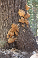
Unusual fungus lives on
the dead tree snag.
A couple ducks waded in the grasses on the far shore, and a Stellar Jay poked near a rotting tree.  Along the trail we photographed a standing dead snag covered in fungus.  Cold Boiling Lake was an interesting trail.
Forest fire destroyed a whole section of the lower slope of Lassen.  The National Park Service is less likely to fight fires now unless the blaze threatens structures.
Fire replenishes, but here
the destruction is apparent.
As part of nature, fire serves to clear the forest floor and return nutrients to the soil.  But it certainly ruins the landscape.
 We parked near the Manzanita Lake Entrance Station to follow the trail around Manzanita Lake.  It was here six years ago in the late afternoon that snow-covered Lassen reflected in the cold lake waters along with the brilliantly-colored foliage of the season.
Lassen rises majestically above Manzanita Lake.
The trail passes through Manzanita brush, open meadows and ponderosa pine forest with alder thickets by the lake.  The green of late summer still predominated, but the views of Lassen Peak and nearby Pilot Pinnacle, 8886 feet; Mount Dillar, 9089 feet; and Brokeoff Mountain, 9235 feet, were breathtaking nevertheless.
Lassen rises 4,625 feet above Manzanita Lake to an elevation of 10,457 feet.  The summit notch in the 1917 crater and the black tongue extending down on the right is the lava flow that poured out as molten dacite on May 19, 1915.  Andy nailed this one again.  This trail is best at the end of the day.
Every view from the lakeshore is picture perfect.
The town of Chester caters to summer tourists.  Antlers Motel had no vacancy, but we’re checked in for more than one night.  And we’ll go back to the Burger Depot for made-to-order burgers and onion rings.  Smothered with mushrooms, Swiss cheese and grilled onions, these burgers were something special.  We even chatted with the owner for 15 minutes.  That’s the “something special” about small town stays.

Sunday, September 25, 2016

RETIREMENT TRIP #7
Mining for Memories in Whiskeytown
                                                    Today is free day in the National Parks.  We drove up to Whiskeytown Lake, north of the town of Shasta, to explore and hike the trails.  Skies were gorgeous blue, but fog spilled over the mountains in the distance.
Three major dams control the watershed of this area: Shasta and Trinity run by the Bureau of Reclamation, and Whiskeytown, run by the National Park Service.
Whiskeytown Lake formed by Whiskeytown Dam offers
recreation on water and land.

A memorial to President John F. Kennedy stands at the
site of the 1963 Whiskeytown Dam dedication ceremony.
Whiskeytown Dam, at 1,210 feet and constructed between 1959 and 1963, was dedicated by President John F. Kennedy just two months before he was assassinated, as part of the California Central Valley Project.
Nearby the entire city of Redding, about 10,000 people, turned out for the dedication ceremony on September 28, 1963.  The dedication completed the Central Valley Project, a 500-mile-long water diversion system, initiating a new era of growth in California.  Water from northern California is diverted to the drier Central Valley, allowing some of the world’s most productive agricultural regions to thrive.
At Whiskeytown in 1935, engineers had blasted a 10.5-mile long, 17.5-foot diameter tunnel through solid granite to divert water from the Trinity to the Sacramento River system.  The resulting lake brought benefits.  But at Whiskeytown, all was not well.
When a watershed is healthy, the ground is like a sponge.  It absorbs winter’s heavy rains.  Spring-fed creeks cascade into rivers and lakes.  Only occasional heavy storms cause mudslides or sediment runoff.  At Whiskeytown, past logging and mining damaged the watershed, reduced vegetation, altered drainage courses and eroded soils.  Mudslides and rain torrents—carrying sediments—occurred more often, reducing water quality and fish habitat.
The Glory Hole Spillway allows water overflow to be
funneled into Clear Creek.
The National Park Service placed high priority on restoring this watershed.
An essential part of the dam, the Glory Hole, is the overflow or built-in spillway.  A few gentle waves lapped over one side.  Seagulls perched on the other edge.  This lake pretty much stays constant in level once the water is under the Glory Hole Spillway, and without water over the spillway, the dam isn’t generating power.  It was built for flood control and stability, an effective site for recreation with little fluctuation.  The circular Glory Hole, located a short distance from shore, allows overflow lake water to drain out.  Water cresting the rim is funneled under the dam into Clear Creek.  It was named “Glory Hole” because it resembles the trumpet-shaped morning glory flower.
Whiskeytown Lake nestles among the hills and valleys of the Klamath Mountains.  Geologic forces created steep and rugged terrain.  Heavy winter rains, long dry summers, and frequent wildfires create diverse habitats, from old-growth forests to oak woodlands and chaparral.
At a backwoods N.E.E.D.S. camp, four deer munched on the grass and low-growing bushes.  This is definitely bear country.  Steel food containers with locks were available at the Horse Camp.
Penstocks carry water from Trinity Lake
to Whiskeytown Lake.
Guardian Rock Loop Trail took us out to Guardian Rock Vista Point on Clear Creek.  The trail, not well maintained, wound up and down.   “I think that water is coming out of Whiskeytown Lake,” said Andy, when we reached Clear Creek.  Clear Creek had a strong flow.  “If that water really flows from Whiskeytown Lake, then there has to be a lower pipe of outtake going through the power plant there,” reasoned Andy.
Penstocks, pipes that funnel water into a hydroelectric plant, carry water about 16 miles from Trinity to Whiskeytown.  The water rushing downhill runs through blades in the plant to produce electricity.
For centuries Wintu Indians enjoyed a prosperous life here.  They gathered acorns, hunted elk and deer, and fished for trout and salmon.  Skilled at crafts, Wintu fashioned tools from obsidian and wove baskets so tightly they could cook liquids in them.   The natural world sustained their way of life for thousands of years.  That is, until the discovery of gold nearby in 1848 nearly destroyed the Wintus and their heritage.
Only Levi Tower's grave is
located in the small
cemetery near Camden's home.
“Our next hike is the Camden Water Ditch Trail,” announced Andy.  It looked like a long one.
The trail took us past a barn built in 1931 by a tenant farmer and to the 1945 grave site of Levi Tower in the woods near his irrigation ditch and mining site on Clear Creek.  Nearby was the home of Tower’s mining partner Charles Camden.
Tower and Camden had become friends and partners in San Francisco in the spring of 1850.  They sailed in search of the Trinity River’s mouth, and then traveled overland to Whiskeytown’s northern diggings.   Camden built a one-room cabin and a mining operation, sawmill and water ditches.  Tower made his fortune by providing food and shelter to miners.  And the Gold Rush was on!
Camden actually took $80,000 worth of gold from the Clear Creek and its tributaries over a period of 18 years.  He made much of his wealth by charging miners for use of his toll road and a toll bridge across Clear Creek:  $.10 for pedestrians, $.25 for a horse and rider and $1.25 for a wagon.  Those were steep rates for the 1800’s.  The bridge owner invested $20,000 in road improvements around the town of Shasta.  With a franchise from the State of California, Camden collected tolls for 50 years from travelers coming and going between Shasta and Weavervile.  Definitely what I would call entrepreneurs!
At Crystal Creek Falls Andy nimbly crosses the creek and
walks along the rock wall to the left.
Levi Tower’s home, Tower House, no longer exists.  Camden House, one of the oldest surviving homes in Shasta County, was closed for the season.  It started as one room in 1852.  We peeked in the windows.  There was minimal furniture, but the house looked comfortable, even by today’s standards.
The trail to Crystal Creek Falls was paved with asphalt for .6 mile one way, but climbing over rocks to the water presented a greater challenge.   Two dads in bare feet watched four little boys dabble their feet in the icy water beneath Crystal Creek Falls.  The youngest one was barely old enough to walk.  What a lovely way to spend a Saturday afternoon with children.

Whiskeytown Falls drops from high
in the mountain.
Andy crossed Crystal Creek on the rocks and climbed the cliff on the other side to the falls.  The oldest boy watched him enviously.
“And how old did you say he was?  Seventeen?” joked the darker-haired dad.
When I told him Andy’s age, he grinned, “Well, more power to him if he can do it!”
It was a small sample of what we had in store ahead at Whiskeytown Falls.  The sign said 1.7 miles to the falls and “Upper Falls Closed.”
“We can do that,” said Andy, grabbing our bottle of water.  “We can do 1.7 miles.”  And so we set out.
The first 300 feet descended to a bridge over Whiskeytown Creek.  After that it was continuous uphill—strenuous uphill.  We climbed for 53 minutes to reach the waterfall, nestled in a cove near the top of the peak.  Whiskeytown Falls plummeted over a granite ledge.  Others enjoyed the cool, peaceful setting with us.
We stop for one last view
of Whiskeytown Lake.
Going back was not nearly as difficult, but we had had our 3.4 mile workout for the day.
We stopped at the Visitor Center for one last view of Whiskeytown Lake.
A brick row of facades is all that
remains of the old mining town of Shasta.
In July, 1848, Pierson B. Reading found gold in nearby Clear Creek.  When word got out, miners rushed to the region.  By 1849, several hundred camped at Reading Springs, not five miles from where Reading had discovered his gold.  They panned in local creeks and streams.  Tents and temporary structures grew into towns.  In 1850, residents officially named Shasta.
Shasta State Historic Park preserved the historic ruins of the old mining town turned commercial center from 1856.  Shasta had burned down twice before Main Street was built with brick. By 1864, Shasta was the town in California with the longest row of brick buildings north of San Francisco.  Most of them are just facades, but it was fun to imagine a bustling rough and ready gold mining center.
The mining didn’t last long, but unlike many other mining towns that “went bust,” Shasta became a commercial center to supply other locales.
Shasta was the starting point for pack trains, the main supply center for all the northern miners. The city became known as the “Head of Whoa! Navigation.”
Well stocked and neatly displayed, the products at Litsch
General Store remind visitors of days gone by.
We walked through the Litsch General Store, now restored to its appearance in the 1880’s.  Even the goods on display are authentic to the time period.
When German native Frank Litsch arrived at Shasta in 1853, his ambition was typical of many early pioneers.  Not content to pursue only his original trade as a baker, he soon involved himself in many different occupations including mining and bartending.
In order to start his business, Frank Litsch needed a suitable building.  He chose the Fuller and Cushing building on the east end of Shasta.  The building had been erected in 1856, well after the town’s devastating fire and therefore had been constructed with all the latest fireproofing elements, such as brick, iron shutters, stout roof beams, and a soil covered roof.  Frank purchased the building for $400, and in November of 1873, he opened his family grocery.
Most canned goods, whether the product was corn, lobster or plums, sold at Litsch’s store for $.25.  Coffee could be purchased for $.25-$.50 a pound.  Twenty-pound hams, cured and shipped to Shasta in large barrels, could be sold for $3.00 a piece.  Frank Litsch’s records show many customers purchased whiskey from his store, which ranged in price from $.75-$1.75 a bottle, depending on the brand.

Today at Shasta Dam we see the top
of Mount Shasta far in the distance.
Our car temperature records 94 degrees.
Frank Litsch diligently recorded each day’s business in a ledger.  These “daybooks” show that, besides selling groceries for cash or on credit, the Litsch Grocery store also offered cash or credit to customers bringing in certain items for resale.  Frequent items accepted for resale were eggs and butter.  There were also shipments of gold dust and checks on Litsch’s behalf.  Business was plentiful!
The zoom lens brings Mount Shasta
into close-up view.
“I’m only going back to the Shasta Dam to see if we can get some clear pictures of the mountain,” said Andy, as we got back in the car.  It was a good decision.  Shasta, snow-capped and cloudless, rose majestically above the lake.  The Visitor Center and dam were closed on Saturday and Sunday, so Andy’s timing was perfect.  We won all the way around.  What a day!   At 6:30 p.m. it was 94 degrees.

Friday, September 23, 2016

RETIREMENT TRIP #7
Shasta: the Dam, the Lake and the Mountain
                                          Shasta Dam is the largest center-flow dam in the world.  The lake formed by the dam is the largest lake in California, and the mountain behind it is one of the tallest in the nation.   The water of Shasta Lake sparkled this morning under a blue sky with only a few cirrus streaks overhead.
Only trickles of water left Shasta Dam, but we could hear
the turbines generating electricity as water poured
through the five exit pipes.
By 1:00 p.m., a few raindrops dotted the car, but in the interim we walked the entire span of Shasta Dam and back—3,460 feet one way plus side views from the parking lots and the visitor center museum.  At 10:30 a.m., we realized free tours could be available and arranged.
“Are you sure this is what you want?” asked Hal at the front desk.   He seemed really gruff.   “We have lots of rules and it takes an hour.”
As we walk from the Visitor Center, the Sacramento River
stretches in a blue ribbon from the base of Shasta Dam.
He gave us tickets and a briefing on security.  “No bags, packages, pocketbooks, backpacks, electronic devices, Fit Bits, food, beverages allowed.  Be at the second station before 11 a.m.  It’s a 15-minute walk out there.  Be on time.” 
I didn’t tell Hal we had already walked well past the second station and back.
Turns out Hal was our tour guide for an hour-and-ten-minute-long walking tour of Shasta Dam.  He took us down 25 stories of the 42 stories to the base of the dam--602 feet from top to bottom, as tall as a 60-story sky scraper.  There he explained the process used to construct the concrete gravity dam, the second largest concrete dam in the United States.  Only Grand Coulee is larger.
Hal shows Andy the size of the release
holes part way down the spillway.
“Where we are standing, there is about 500 feet of concrete separating us from Shasta Lake,” he said.  The dam is 883 feet thick at the base and took 6.5 million cubic yards of concrete, weighing 15 million tons, to build.
Hal explained how workers poured 15 boxes at a time and each box took 58 buckets of cement before the form was removed.  Tubes kept the concrete from hardening too fast.  Moisture flows between the blocks, so the dam will not be completely cured until 2045, when it will be 100 years old.
Average pay for the construction workers from 1938 to 1945 was $.40 an hour, but the men filling the concrete boxes got $.90 an hour or $7.20 a day.  That was really good money for the early 1940’s.
Inside the dam, five turbines generate
electricity for northern California.
In 1942, many of the workers wanted to join the war effort after the bombing of Pearl Harbor.   President Franklin D. Roosevelt decreed the workers would get military status and come under the GI bill so that they wouldn’t abandon such a critical project.
Started in 1938, the Shasta Dam was completed ahead of schedule in 1945.  Today it backs up water for more than 35 miles to form Shasta Lake, California’s largest reservoir.
Shasta Lake actually extends for 35 miles north of the dam.
Hal told us that the greatest benefit is for Central Valley agriculture irrigation, even though the dam was initially for flood control.
“Now it is the key storage facility in one of the world’s most elaborate and extensive water development projects—the Central Valley Project, one of the leading agricultural producers in the world,” said Hal.
Today Shasta Lake is a clean, dependable water supply for irrigation, municipal and industrial use.  The wildlife habitat maintenance and power generation as well benefit millions of people miles away from the shores of this recreational paradise.
Far in the distance, Mount Shasta, hidden in clouds,
rises majestically with snow-capped peak.
Hal told us that initial plans to raise the dam 18.5 feet had been proposed.  He didn’t foresee it happening in the current political climate, but he thought given four more years, the proposal might well come to fruition.  That would raise the depth of the water in Shasta Lake from its current maximum of 517 feet and make more water storage possible.
We drove farther north in the early afternoon to check out the extent of the lake.  It was lower and its bathtub ring more evident the farther north we went, but the rainy season is coming.
Farther north in the recreation areas, the water level is lower,
but rainy season is coming soon by the looks of the clouds.
Hal had told us that some years ago the water level at the dam went up 33 feet in one day when lots of rain came down upriver.  The average rainfall in the watershed is 62-72 inches a year, with 90% of Shasta Lake water from rain and only 10% from snow.   It surprised us when he said that temperatures here could reach 112 to 120 degrees.
The greatest improvement in the dam since its completion in 1945 was the Temperature Control Device (TCD), put into operation in 1997.  Never before attempted, this device helped to protect the eggs of the Chinook salmon.  Two years in the making, it required 20,000 hours of deep-water saturation dives to assemble the 9,000 tons of steel and affix it to the face of the dam. The cost exceeded 80 million dollars.  This was the long-term fix designed by engineers and biologists to create a multi-level intake device to direct cold water releases through the power plant to meet project water and power demands without adversely affecting environmental needs.
Like so may who use Shasta for
recreational purposes, Andy and Sue
stop for lunch on the deck.
What TCD allowed operators to do was increase or decrease water flow from different levels of the lake through spillway valves at different elevations where the lake water was colder.  Biologists had discovered that the survival rate of the eggs of Chinook salmon greatly increased if the water temperature was below 56 degrees Fahrenheit.  The cold water released from lower levels of the dam help achieve the temperature needs of the eggs.
Certainly a deterrent, the rattlesnake
sign warns visitors not to venture
into restricted areas by the dam.
This all came about because over a period of years Chinook salmon and steelhead in the Sacramento River had suffered decline due to logging, mining operations and warm water temperatures in the Sacramento.  As Reclamation and other agencies studied the situation, they learned that the mortality rate could be improved by providing colder water releases from Shasta dam.  Hence, TCD.
Back in Redding, we check out the
superstructure under the Sundial Bridge
for a different perspective.
Thanks to Hal, our tour had been amazing.
We headed back to Redding for more walking and some different views of the Sundial.
In the northwestern part of town the McConnell Foundation has set aside a huge park with four small lakes for walking, the Lema Ranch Trails.

From Leah's Loop, one of the Lema Ranch Trails,
the mountains in the distance line the horizon.
We chose Leah’s Loop, a 1.75-mile trail on an asphalt path around the lakes and the private Lema Ranch house.  The scenery was beautiful, and there was even a dam and spillway inside the private area.  It was a gorgeous piece of property and a great way to build up an appetite for dinner.

Thursday, September 22, 2016

RETIREMENT TRIP #7
Heading Back Inland over the Mountains
                                                                 It’s autumn now.  There was no rain in the forecast for Fortuna, but when we looked outside at 6:30 a.m., everything was wet. 
“56 degrees,” announced Andy, as he pumped gas for the Fiesta.
“Nice shower,” greeted the attendant.
A crow fluttered and splashed in a parking lot puddle.  Today everyone here welcomed the rain.  But it was also a sign that winter was coming.  With that, we headed inland.
A steep, winding, narrow road led across the Coastal Range.  I checked the map for a specific name, but I couldn’t find one.
After a forest fire, logs on the ground have already been
felled for pickup and harvest by logging companies.
“On some of these rises and falls and bends and twists, a car could go airborne if the driver takes it fast enough,” said Andy.  A pick-up zoomed past us around a bend.  Later a trailer pulling a jeep sped past going the other way.  There were lots of spots labeled “flagger ahead” and “one lane road” and “road work.”  A semi pulled to a stop behind us at one work site.
“I thought this road wasn’t recommended for large vehicles,” said Andy, looking in his rearview mirror, “but then again there are a few small towns that probably need servicing.”
Lumber trucks went by.  Empty, they were hauling the logs inland.  At 4,077 feet in Shasta-Trinity National Forest, our car said 45 degrees.
Pullouts offer spectacular views of the
mountains in the distance.
“It’s fall here,” said Andy.  But with spruce and fir the primary vegetation, the green still predominated.
This area probably gets lots of snow.  Signs that most likely advised “chaining” or “closed due to snow” were turned inward away from the road on some of the higher curves.
Burned hillsides stretched across the tops of the peaks on both sides of the roads, but here in Shasta-Trinity National Forest, the larger burned trees were being harvested.  Some green undergrowth had started, so the fire probably occurred a year ago.  The largest logs lay felled on the ground, ready to be loaded and hauled away.
“That’s good,” said Andy.  “At least some is being used, and the smaller stuff returns as nutrient to the soil.”
Pullouts offered beautiful views of peaks in the distance, but it was a cold 50 degrees to step out of the car, even in the bright sunlight.
Platina General Store recalls days gone by.
We stopped for coffee in Platina at a general store in operation since 1902.  A sign outside advertised for substitute teachers—Bachelor’s Degree and California BEST certification required.
Just outside of Platina, a sign said 41 miles to Redding, our destination for the night.
I read the warning: narrow, winding road.  No turn-arounds for ten miles.
Even the little Fiesta could barely negotiate the pullouts, much less turn around to go the other way!  But the panoramic views were incredible—at least 50 miles in both directions.  They get less rain here.  Grasses, Manzanita, California oak and tall, thin pine trees covered the slopes, but the undergrowth was minimal.
Low key and beautiful, Platina Road scenery makes up
for the unexpected road closure at ten miles in.
An old barn caught my eye.  With cow trails nearby and California oak trees neatly spaced, it looked like a prosperous location.  But on the fence, the “For Sale” foretold of difficult times.
At ten miles in, the road was closed—no warning, no turn around and no through access.  We could do nothing but turn around carefully in the road and head back to Platina.  We’d have to drive to Redding by way of Red Bluff, an extra 40 miles.
“No wonder there were no cars,” said Andy.
“It’s pretty at least,” I added.
“Yup,” he agreed.  “It’s always pretty when you have no cares!”
A grass fire outside of Red Bluff set off all kinds of alarms in this fire-prone dry season.  Three water trucks and a bull dozer raced by with sirens blaring, soon after we had passed the burning roadside.
It was warm in Redding at 2:15 p.m.  No jacket and short sleeves warm.  But we’re inland, only 300 feet in elevation and far away from the water now.
Standing on the glass deck bridge over the
Sacramento River, Andy basks in the sun.
In downtown Redding, the Sundial Bridge is the only one of its kind in North America and the tallest working sundial in the world.  We found our way to the Turtle Bay Exploration Park at the confluence of Sulphur Creek and the Sacramento River, parked and explored for an hour or more.
“It’s only accurate one day a year,” said the security guard, after we had walked across.  “The sundial gives perfect time on June 21st, the summer solstice.”  Then the shadow moves one foot per minute from 11 a.m. to 3 p.m.
When Andy's watch read 2:55 p.m. today, the sundial said 3:00 p.m.
An interpretive sign explained that the bridge with its walkway of thick glass was more than a steel suspension bridge.  “A bridge is a metaphor for communication, connection, triumph over obstacles—even peace.   The very term ‘bridging’ describes a creative and unifying endeavor.”
Sundial Bridge was designed with the local topography, wildlife, environment and human uses all taken into account.  It was described as “an intersection of the human and natural worlds.”
Sundial Bridge, the only one of its kind in the world,
accurately tells the time of day... one day a year.
Gravity keeps the bridge from falling down.  The pylon and glass deck pull on one another through the cables.  The tension supports both:  the weight of the pylon holds up the deck and the weight of the deck keeps the pylon from falling over.
The pylon is 217 feet high, so tall it requires a red aircraft-warning light at the top.  It points directly north.
More than one million ceramic tiles cover the concrete surface, and the foundation is up to 50 feet deep.  There are 14 cables, with a total length of 4,342 feet, which support the bridge.
Rising 217 feet in the air, the pylon is set
at a 42-degree angle.
Sundial Bridge is designed to flex, sway, expand and contract to absorb changes in the load.
To protect salmon spawning beds, no part of the bridge touches the water except during seasonal floods, and the translucent glass deck allows light to reach the water below.
The Turtle Bay Arboretum and Children’s Exploration Park were free with suggested donation.  The grounds featured plants that thrived in a Mediterranean climate, like the Mexican petunia and the agave.  Young parents pushed strollers, people walked dogs and grandparents pointed out unique grasses and flowers to school-age grandchildren.
Flowers thrive in the warm
Mediterranean climate.
The sun beat down.  It was hot and dry.  Our heels kicked up little poufs of dirt from the dry path.
But what a lovely facility and a source of horticultural information for a small town!  I told Andy I wanted to come back tomorrow.