RETIREMENT TRIP #7
Heading Back Inland over the Mountains
It’s autumn now. There was no
rain in the forecast for Fortuna, but when we looked outside at 6:30 a.m.,
everything was wet.
“56 degrees,” announced Andy, as he pumped gas for the Fiesta.
“Nice shower,” greeted the attendant.
A crow fluttered and splashed in a parking lot puddle. Today everyone here welcomed the rain. But it was also a sign that winter was
coming. With that, we headed inland.
A steep, winding, narrow road led across the Coastal Range. I checked the map for a specific name, but I
couldn’t find one.
 |
| After a forest fire, logs on the ground have already been felled for pickup and harvest by logging companies. |
“On some of these rises and falls and bends and twists, a car could go
airborne if the driver takes it fast enough,” said Andy. A pick-up zoomed past us around a bend. Later a trailer pulling a jeep sped past
going the other way. There were lots of
spots labeled “flagger ahead” and “one lane road” and “road work.” A semi pulled to a stop behind us at one work
site.
“I thought this road wasn’t recommended for large vehicles,” said Andy,
looking in his rearview mirror, “but then again there are a few small towns
that probably need servicing.”
Lumber trucks went by. Empty,
they were hauling the logs inland. At
4,077 feet in Shasta-Trinity National Forest, our car said 45 degrees.
 |
| Pullouts offer spectacular views of the mountains in the distance. |
“It’s fall here,” said Andy. But
with spruce and fir the primary vegetation, the green still predominated.
This area probably gets lots of snow.
Signs that most likely advised “chaining” or “closed due to snow” were
turned inward away from the road on some of the higher curves.
Burned hillsides stretched across the tops of the peaks on both sides
of the roads, but here in Shasta-Trinity National Forest, the larger burned
trees were being harvested. Some green
undergrowth had started, so the fire probably occurred a year ago. The largest logs lay felled on the ground,
ready to be loaded and hauled away.
“That’s good,” said Andy. “At
least some is being used, and the smaller stuff returns as nutrient to the
soil.”
Pullouts offered beautiful views of peaks in the distance, but it was a
cold 50 degrees to step out of the car, even in the bright sunlight.
 |
| Platina General Store recalls days gone by. |
We stopped for coffee in Platina at a general store in operation since
1902. A sign outside advertised for
substitute teachers—Bachelor’s Degree and California BEST certification
required.
Just outside of Platina, a sign said 41 miles to Redding, our
destination for the night.
I read the warning: narrow, winding road. No turn-arounds for ten miles.
Even the little Fiesta could barely negotiate the pullouts, much less
turn around to go the other way! But the
panoramic views were incredible—at least 50 miles in both directions. They get less rain here. Grasses, Manzanita, California oak and tall,
thin pine trees covered the slopes, but the undergrowth was minimal.
 |
| Low key and beautiful, Platina Road scenery makes up for the unexpected road closure at ten miles in. |
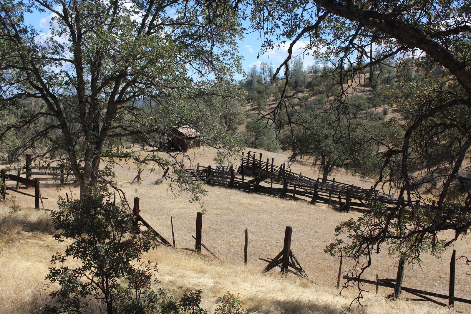
An old barn caught my eye. With
cow trails nearby and California oak trees neatly spaced, it looked like a
prosperous location. But on the fence,
the “For Sale” foretold of difficult times.
At ten miles in, the road was closed—no warning, no turn around and no
through access. We could do nothing but
turn around carefully in the road and head back to Platina. We’d have to drive to Redding by way of Red
Bluff, an extra 40 miles.
“No wonder there were no cars,” said Andy.
“It’s pretty at least,” I added.
“Yup,” he agreed. “It’s always
pretty when you have no cares!”
A grass fire outside of Red Bluff set off all kinds of alarms in this
fire-prone dry season. Three water
trucks and a bull dozer raced by with sirens blaring, soon after we had passed
the burning roadside.
It was warm in Redding at 2:15 p.m.
No jacket and short sleeves warm.
But we’re inland, only 300 feet in elevation and far away from the water
now.
 |
| Standing on the glass deck bridge over the Sacramento River, Andy basks in the sun. |
In downtown Redding, the Sundial Bridge is the only one of its kind in
North America and the tallest working sundial in the world. We found our way to the Turtle Bay Exploration
Park at the confluence of Sulphur Creek and the Sacramento River, parked and
explored for an hour or more.
“It’s only accurate one day a year,” said the security guard, after we
had walked across. “The sundial gives
perfect time on June 21st, the summer solstice.” Then the shadow moves one foot per minute
from 11 a.m. to 3 p.m.
When Andy's watch read 2:55 p.m. today, the sundial said 3:00 p.m.
An interpretive sign explained that the bridge with its walkway of
thick glass was more than a steel suspension bridge. “A bridge is a metaphor for communication,
connection, triumph over obstacles—even peace.
The very term ‘bridging’ describes a creative and unifying endeavor.”
Sundial Bridge was designed with the local topography, wildlife,
environment and human uses all taken into account. It was described as “an intersection of the
human and natural worlds.”
 |
| Sundial Bridge, the only one of its kind in the world, accurately tells the time of day... one day a year. |
Gravity keeps the bridge from falling down. The pylon and glass deck pull on one another
through the cables. The tension supports
both: the weight of the pylon holds up
the deck and the weight of the deck keeps the pylon from falling over.
The pylon is 217 feet high, so tall it requires a red aircraft-warning
light at the top. It points directly
north.
More than one million ceramic tiles cover the concrete surface, and the
foundation is up to 50 feet deep. There
are 14 cables, with a total length of 4,342 feet, which support the bridge.
 |
| Rising 217 feet in the air, the pylon is set at a 42-degree angle. |
Sundial Bridge is designed to flex, sway, expand and contract to absorb
changes in the load.
To protect salmon spawning
beds, no part of the bridge touches the water except during seasonal floods,
and the translucent glass deck allows light to reach the water below.
The Turtle Bay Arboretum and Children’s Exploration Park were free with
suggested donation. The grounds featured
plants that thrived in a Mediterranean climate, like the Mexican petunia and
the agave. Young parents pushed
strollers, people walked dogs and grandparents pointed out unique grasses and
flowers to school-age grandchildren.
 |
| Flowers thrive in the warm Mediterranean climate. |
The
sun beat down. It was hot and dry. Our heels kicked up little poufs of dirt from
the dry path.
But what a lovely facility and a source of horticultural information
for a small town! I told Andy I wanted
to come back tomorrow.
No comments:
Post a Comment