RETIREMENT TRIP #7
Mining for Memories in Whiskeytown
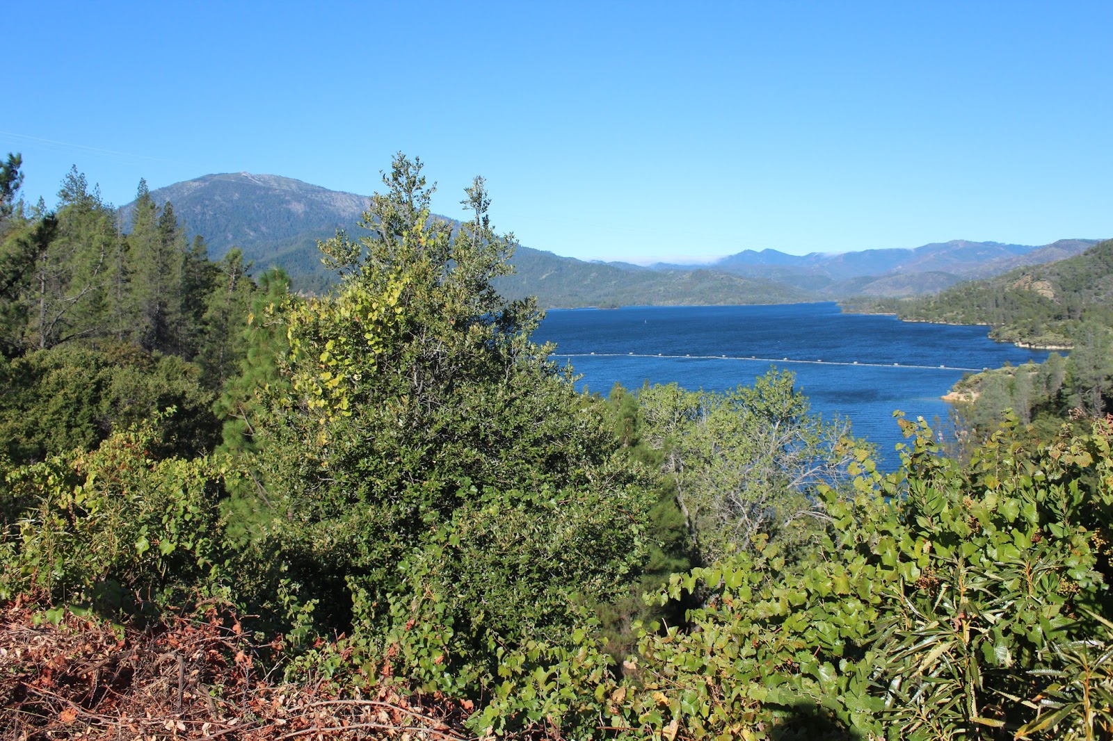
Today is free day in the National Parks. We drove up to Whiskeytown Lake, north of the
town of Shasta, to explore and hike the trails.
Skies were gorgeous blue, but fog spilled over the mountains in the
distance.
Three major dams control the watershed of this area: Shasta and Trinity
run by the Bureau of Reclamation, and Whiskeytown, run by the National Park Service.
 |
| Whiskeytown Lake formed by Whiskeytown Dam offers recreation on water and land. |
 |
| A memorial to President John F. Kennedy stands at the site of the 1963 Whiskeytown Dam dedication ceremony. |
Nearby the entire city of Redding, about 10,000 people, turned out for
the dedication ceremony on September 28, 1963.
The dedication completed the Central Valley Project, a 500-mile-long
water diversion system, initiating a new era of growth in California. Water from northern California is diverted to
the drier Central Valley, allowing some of the world’s most productive
agricultural regions to thrive.
At Whiskeytown in 1935, engineers had blasted a 10.5-mile long,
17.5-foot diameter tunnel through solid granite to divert water from the
Trinity to the Sacramento River system.
The resulting lake brought benefits.
But at Whiskeytown, all was not well.
When a watershed is healthy, the ground is like a sponge. It absorbs winter’s heavy rains. Spring-fed creeks cascade into rivers and lakes. Only occasional heavy storms cause mudslides
or sediment runoff. At Whiskeytown, past
logging and mining damaged the watershed, reduced vegetation, altered drainage courses
and eroded soils. Mudslides and rain
torrents—carrying sediments—occurred more often, reducing water quality and
fish habitat.
 |
| The Glory Hole Spillway allows water overflow to be funneled into Clear Creek. |
An essential part of the dam,
the Glory Hole, is the overflow or built-in spillway. A few gentle waves lapped over one side. Seagulls perched on the other edge. This lake pretty much stays constant in level
once the water is under the Glory Hole Spillway, and without water over the spillway,
the dam isn’t generating power. It was
built for flood control and stability, an effective site for recreation with
little fluctuation. The circular Glory
Hole, located a short distance from shore, allows overflow lake water to drain
out. Water cresting the rim is funneled
under the dam into Clear Creek. It was
named “Glory Hole” because it resembles the trumpet-shaped morning glory
flower.
Whiskeytown Lake nestles among the hills and valleys of the Klamath
Mountains. Geologic forces created steep
and rugged terrain. Heavy winter rains,
long dry summers, and frequent wildfires create diverse habitats, from
old-growth forests to oak woodlands and chaparral.
At a backwoods N.E.E.D.S. camp, four deer munched on the grass and
low-growing bushes. This is definitely
bear country. Steel food containers with
locks were available at the Horse Camp.
 |
| Penstocks carry water from Trinity Lake to Whiskeytown Lake. |
Guardian Rock Loop Trail took us out to Guardian Rock Vista Point on
Clear Creek. The trail, not well
maintained, wound up and down. “I think that water is coming out of
Whiskeytown Lake,” said Andy, when we reached Clear Creek. Clear Creek had a strong flow. “If that water really flows from Whiskeytown
Lake, then there has to be a lower pipe of outtake going through the power
plant there,” reasoned Andy.
Penstocks, pipes that funnel water into a hydroelectric plant, carry
water about 16 miles from Trinity to Whiskeytown. The water rushing downhill runs through blades
in the plant to produce electricity.
For centuries Wintu Indians enjoyed a prosperous life here. They gathered acorns, hunted elk and deer,
and fished for trout and salmon. Skilled
at crafts, Wintu fashioned tools from obsidian and wove baskets so tightly they
could cook liquids in them. The natural world sustained their way of life
for thousands of years. That is, until
the discovery of gold nearby in 1848 nearly destroyed the Wintus and their
heritage.
 |
| Only Levi Tower's grave is located in the small cemetery near Camden's home. |
The trail took us past a barn built in 1931 by a tenant farmer and to
the 1945 grave site of Levi Tower in the woods near his irrigation ditch and
mining site on Clear Creek. Nearby was
the home of Tower’s mining partner Charles Camden.
Tower and Camden had become friends and partners in San Francisco in
the spring of 1850. They sailed in
search of the Trinity River’s mouth, and then traveled overland to Whiskeytown’s
northern diggings. Camden built a one-room cabin and a mining
operation, sawmill and water ditches.
Tower made his fortune by providing food and shelter to miners. And the Gold Rush was on!
Camden actually took $80,000 worth of gold from the Clear Creek and its
tributaries over a period of 18 years.
He made much of his wealth by charging miners for use of his toll road
and a toll bridge across Clear Creek:
$.10 for pedestrians, $.25 for a horse and rider and $1.25 for a
wagon. Those were steep rates for the
1800’s. The bridge owner invested
$20,000 in road improvements around the town of Shasta. With a franchise from the State of California,
Camden collected tolls for 50 years from travelers coming and going between
Shasta and Weavervile. Definitely what I
would call entrepreneurs!
 |
| At Crystal Creek Falls Andy nimbly crosses the creek and walks along the rock wall to the left. |
Levi Tower’s home, Tower House, no longer exists. Camden House, one of the oldest surviving
homes in Shasta County, was closed for the season. It started as one room in 1852. We peeked in the windows. There was minimal furniture, but the house
looked comfortable, even by today’s standards.
The trail to Crystal Creek Falls was paved with asphalt for .6 mile one
way, but climbing over rocks to the water presented a greater challenge. Two dads in bare feet watched four little
boys dabble their feet in the icy water beneath Crystal Creek Falls. The youngest one was barely old enough to
walk. What a lovely way to spend a
Saturday afternoon with children.
Andy crossed Crystal Creek on the rocks and climbed the cliff on the
other side to the falls. The oldest boy
watched him enviously.
 |
| Whiskeytown Falls drops from high in the mountain. |
“And how old did you say he was?
Seventeen?” joked the darker-haired dad.
When I told him Andy’s age, he grinned, “Well, more power to him if he
can do it!”
It was a small sample of what we had in store ahead at Whiskeytown
Falls. The sign said 1.7 miles to the
falls and “Upper Falls Closed.”
“We can do that,” said Andy, grabbing our bottle of water. “We can do 1.7 miles.” And so we set out.
The first 300 feet descended to a bridge over Whiskeytown Creek. After that it was continuous uphill—strenuous
uphill. We climbed for 53 minutes to
reach the waterfall, nestled in a cove near the top of the peak. Whiskeytown Falls plummeted over a granite
ledge. Others enjoyed the cool, peaceful
setting with us.
 |
| We stop for one last view of Whiskeytown Lake. |
Going back was not nearly as difficult, but we had had our 3.4 mile
workout for the day.
We stopped at the Visitor Center for one last view of Whiskeytown Lake.
 |
| A brick row of facades is all that remains of the old mining town of Shasta. |
Shasta State Historic Park preserved the historic ruins of the old
mining town turned commercial center from 1856.
Shasta had burned down twice before Main Street was built with brick. By
1864, Shasta was the town in California with the longest row of brick buildings
north of San Francisco. Most of them are
just facades, but it was fun to imagine a bustling rough and ready gold mining
center.
The mining didn’t last long, but unlike many other mining towns that “went
bust,” Shasta became a commercial center to supply other locales.
Shasta was the starting point for pack trains, the main supply center
for all the northern miners. The city
became known as the “Head of Whoa! Navigation.”
 |
| Well stocked and neatly displayed, the products at Litsch General Store remind visitors of days gone by. |
We walked through the Litsch General Store, now restored to its
appearance in the 1880’s. Even the goods
on display are authentic to the time period.
When German native Frank Litsch arrived at Shasta in 1853, his ambition
was typical of many early pioneers. Not
content to pursue only his original trade as a baker, he soon involved himself
in many different occupations including mining and bartending.
In order to start his business, Frank Litsch needed a suitable
building. He chose the Fuller and
Cushing building on the east end of Shasta.
The building had been erected in 1856, well after the town’s devastating
fire and therefore had been constructed with all the latest fireproofing
elements, such as brick, iron shutters, stout roof beams, and a soil covered
roof. Frank purchased the building for
$400, and in November of 1873, he opened his family grocery.
Most canned goods, whether the product was corn, lobster or plums, sold
at Litsch’s store for $.25. Coffee could
be purchased for $.25-$.50 a pound. Twenty-pound
hams, cured and shipped to Shasta in large barrels, could be sold for $3.00 a
piece. Frank Litsch’s records show many
customers purchased whiskey from his store, which ranged in price from
$.75-$1.75 a bottle, depending on the brand.
Frank Litsch diligently recorded each day’s business in a ledger. These “daybooks” show that, besides selling
groceries for cash or on credit, the Litsch Grocery store also offered cash or
credit to customers bringing in certain items for resale. Frequent items accepted for resale were eggs
and butter. There were also shipments of
gold dust and checks on Litsch’s behalf.
Business was plentiful!
 |
| Today at Shasta Dam we see the top of Mount Shasta far in the distance. Our car temperature records 94 degrees. |
 |
| The zoom lens brings Mount Shasta into close-up view. |
“I’m only going back to the Shasta Dam to see if we can get some clear
pictures of the mountain,” said Andy, as we got back in the car. It was a good decision. Shasta, snow-capped and cloudless, rose
majestically above the lake. The Visitor
Center and dam were closed on Saturday and Sunday, so Andy’s timing was
perfect. We won all the way around. What a day!
At 6:30 p.m. it was 94 degrees.
No comments:
Post a Comment