ON TOP OF THE WORLD
September 2015
“It’s not that bad,” said Andy, as we
packed up in Richfield this morning. The
sun shined brightly, and there wasn’t a cloud in the sky.
I shivered. “If you plan to hike in the near future, I
want my jacket.”“It’s balmy. You don’t need a jacket,” he said, getting into the car.
“I’m just warning you, if you want to
hike.”
“But it’s still summer, and it’s
lovely,” Andy argued. |
| The bridge over the creek at Big Rock Candy Mountain resort offers an ideal spot for photographs. |
I looked at the car thermometer. It was 46 degrees.
The parking lot was busy; everyone was dressed in warmer gear than we had on. But then again everyone else was on motorcycles. The Quality Inn had no vacancy, and all rooms were apparently taken by older adults, because of a huge motor cross event today in Richfield.
“It’s known worldwide. It’s a very popular event,” the desk clerk had told one visitor.
 |
| Jagged rock spires provide interesting scenery along Route 89. |
The road climbed into some rugged terrain at the edge of Paiute County. There, nestled between jagged rock cliffs and spires, was Big Rock Candy Mountain, a resort with colorful old railroad cars.
A nearby reservoir had opened the floodgates, so the creek adjoining Route #89 flowed right to the top of its banks. A couple donkeys grazed in one field, and a covey of quail dashed across the road. A mile or so up the hill the campground was filled with trailers. Most of them had jeeps and off-road vehicles or motorcycles.
 |
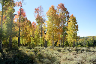
| Aspen form the backdrop for a wedding in the Dixie National Forest. |
 |
| Dixie National Forest bursts with color as leaves shimmer in the breeze. |
There wasn’t any snow on top yet. From the map I identified the peak as Mount
Belknap at 12,119 feet.
Miles down the road the reservoir was mostly
mud flats. True, it’s heading into fall so water level would be down, but to an
Easterner, it seems lack of water is a terribly serious issue for this part of
the country. We stopped several times along Route #89 as we headed south. Each time the mountains to the west looked increasingly more jagged.
“Rattlesnakes live there,” said Andy, pointing to one grouping of spires.
“Guess I won’t be hiking it then,” I countered.
“It’s not cold outside,” said Andy. “It’s so nice in the sun.”
It was 54 degrees.
As I took pictures, he introduced himself to a herd of Black Angus across the street.
The loud moos echoed repeatedly across the canyon, bouncing from side to side around us. It definitely upset the herd. One disgruntled adult mooed back loudly and repeatedly, adding to the commotion of echoes. Then the herd retreated.
Lots of people fished on Panguitch Lake, but it was Saturday during senior citizen vacation season.
We stopped in Dixie National Forest to photograph one of the lava flows.
“This
road closes in the winter,” said Andy, “and Cedar Breaks up ahead of us closes
the first week in October.”
I put on my jacket and watched him climb
to the top of the lava flow.
 |
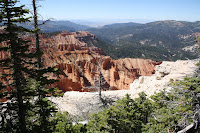
| The white ledge at Sunset View glistens brilliantly at noon. |
I wasn’t about to try.
“It’s definitely fall above the 9,000
foot elevation,” said Andy. All the
aspen trees had turned brilliant yellow and reddish orange in Dixie National
Forest. A turnoff had a sign for a
wedding. Gorgeous day and gorgeous location!
The higher we climbed, the more
color. At the entrance to Cedar Breaks
National Monument, the aspen disappeared and were replaced by cedars. But whole slopes of the cedars were dead.
That’s the beetle,” said Andy. “The climate has warmed up just enough for
the beetle to thrive, and there is no remedy.
Fire slows it down, but the beetle just sucks the life out of a tree in
about three years.”
We didn’t stay long at Chessman Ridge
Overlook. A group of about 30 seniors
with dogs had met for a convention of picture-taking. A couple deep breaths of pungent cedar and
Andy said, “Let’s go. We’ll find another
spot.”
We had Sunset View at 10,354 feet all to
ourselves.
 |
| Healthy Bristlecone Pine trees line the cliff edge near Spectra Point. |
The Civilian Conservation Corps (CCC) boys in 1934, built this
overlook and lived across the road in tents.
They received $30 a month with food and lodging in the tents, but they
were required to send $25 of it home to their families.
 |
| Two miles from the Visitor Center at Point Supreme Andy reaches the end of Ramparts Trail. |
“This is our hike for the day,” said
Andy. And so it was we set out on the
Ramparts Trail for Spectra Point at 10,285 feet. The narrow trail followed the rim and skirted
the edge of the canyon for a mile to a grove of Bristlecone Pine trees. The sign explained that these trees are the
oldest living organism on earth and that they can survive best up to 10,000
feet. Controlling factor is moisture
more than altitude though. Some trees in
the grove were estimated to be more than 2,000 years old.
 |
| With a dead Bristlecone as the backdrop, Sue reaches the end of the trail. |
Only a few other people had hiked the one-way
mile to Spectra Point. I spoke with one
couple who made their home in France.
They had never heard of Bristlecone Pines.
“Okay, are you ready to go back?” asked
Andy.
“No, I can handle it,” I said. I knew he
was politely testing my endurance, but he really wanted to continue.
 |
| Ramparts Trail offers one spectacular view after another. |
 |
| Climbing back up the rim along Ramparts Trail we see amazing vistas at every turn. |
The second leg of Ramparts Trail to Ramparts Overlook at 9,952 feet included nine major downhill switchbacks, descending another mile to Ramparts Overlook. And we had it totally to ourselves.
 |
| We make it back to the top of the world! |
After a 3:00 p.m. cookie break, we
headed for Brian’s Head, the highest peak in the surrounding area at 11,307
feet. Others at the summit marveled at
the 360-degree view of the world with vistas to the horizon in every direction.
Alpine plants totally surrounded a stone
shelter at the summit. It had been
constructed by the CCC (Civilian Conservation Corps) in 1935 and renovated by
the Sierra Club in 1995.
 |
| Fall color dominates the landscape below as aspen trees change near the rim of the red sandstone canyon. |
The average snowfall in the monument is
15 feet. The record in one season is 46
feet.
No snow this visit to Cedar Breaks, but
even so, the scenery couldn’t be more magnificent.
 |
| The summit house perched at the top of Brian's Head looks out of a 360-degree view of the world below. |
As we headed north on Interstate #15,
Andy reminded me, “We drove through here two years ago, but then it was about
three weeks later in the year, and the hills and peaks on both sides of the
road were covered with snow.”
There certainly wasn’t any snow
today. Sheep grazed peacefully, a feed
lot swarmed with cattle, ranchers were out cutting and bailing in the fields,
and now our car thermometer read 82 degrees.
It was a beautiful Saturday.

No comments:
Post a Comment