RETIREMENT TRIP #7
Hood River Valley Exploration
On the road by 8 a.m., we passed the wind farm again. The windmills were all gracefully spinning in
the early morning breeze.
“Maybe we could put one in our yard,” I mused out loud. “They are so pretty to look at and we could
even generate electricity and save money.”
Andy scowled. “They kill lots of
birds,” he countered. “I guess birds try
to land on them—big birds—birds of prey like hawks and eagles and falcons. They must misjudge the power of the blades.”
“Woodpeckers!” I exclaimed. “We
could put up a windmill and get the woodpeckers!” All summer we had battled woodpeckers on the
hummingbird feeders. “Could you call
that killing two birds with one windmill?”
He didn’t think I was funny.
 |
| Wide and beautiful, the Columbia from Rowena Crest, looks more like a huge lake. |
A couple turns and we were following the mighty Columbia along a narrow
road through the country at the base of the Gorge to the Rowena Crest
Viewpoint.
 |
| Spectacular, rugged country spreads in every direction from Rowena Crest. |
Wind whipped across the plateau at Rowena Loops. We walked around the circle for views of the
river far below and the famous Rowena Loops Road that circled the canyon wall
to the top of the plateau. A cold wind
made it hard to steady the camera, but the scenes were magnificent.
 |
| The graceful S-curve of Rowena Loops almost doubles back on itself. |
Cataclysmic floods during the twilight of the Ice Age affected the
landscape, creating scablands called the Rowena Plateau. The massive ice sheet that covered Canada
dammed rivers up to 2,000 feet thick with glacial ice. The largest of these held more than 500 cubic
miles of water. Rising waters undermined
the ice dams, causing huge floods to sweep down the Columbia, scouring the land
as many as 100 times and creating the formations of today.
 |
| Away from the ridge, the country side offers peace. |
At Memaloose Overlook we read about the ancient Indian practice of
leaving their dead in a canoe on an island in the middle of the Columbia
River. The bodies were wrapped in robes
or tule mats. Memaloose is derived from
the Chinook word “memalust,” which means “to die.” Lewis and Clark named the island Sepulcher
Island and visited it in 1806.
 |
| Far below and to the right is all that remains of Memaloose Island. |
 |
| The singular monument marks the grave of pioneer Victor Trevitt. |
 |
| From the top of the Memaloose Viewpoint, we see Mount Hood. Mount Adams was also visible. |
In the other direction we could see wind surfers sweeping back and
forth across the Columbia, their fluorescent green sails twisting and turning
in the wind. The gusts must have been 50
m.p.h., since I couldn’t hold the camera steady. “Down there, they’re lovin’ it!” said
Andy. White caps dotted the whole river
from shore to shore.
With careful map reading we found Panorama Point in the Panorama Point
County Park. The guidebook said this
stop offered “the best views of the Hood River Valley, stretching from Mount
Hood to the Columbia River Gorge.” The
view features more than 15,000 acres of orchards and vineyards. A tower at the viewpoint actually decorates
one of the stations of the power lines that stretch from a dam on the
Columbia. It was a clever way to lend
beauty to something detracting and ugly on the landscape.
Bradford Island Visitor Center at Bonneville Dam was a couple miles in
from the main road and a security check of the car by an armed guard.
We watched the salmon and sturgeon navigate the fish ladders from
outside above the water and inside beneath the water. What a fascinating display of power and
determination!
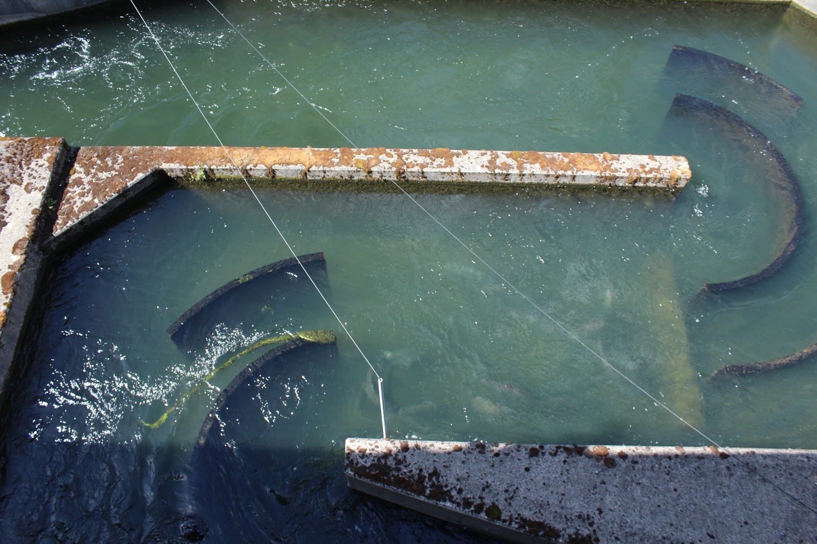 |
| Visible under the water, salmon climb the fish ladders. |
“Lots of injured ones come through,” said one guide, “because of all
the sea lions below the dam.”
We didn’t see any sea lions.
 |
| Salmon and sturgeon climb the fish ladders in full view of the public at Bonneville Dam. |
Inside the Visitor Center I read all kinds of interesting facts about
the dam. Studies have shown that fish
now swim past the dam just as successfully as they swim through comparable
undammed rivers.
The dam has a spillway, like all dams, for when flow is excessive. With the spillway open wide, the water flow
is 12,000,000 gallons per second.
Construction of Bonneville by the Army Corps of Engineers began in 1933,
and the lock and dam was dedicated by President Franklin D. Roosevelt on
September 28, 1937. Then the total
construction cost was $88.4 million.
Bonneville Lock and Dam is named for Army Captain Benjamin Bonneville,
an early day visionary who led an exploration to the Oregon Country and charted
extensive sections of what became the Oregon Trail.
Lake Bonneville, the 48-mile long reservoir impounded by the dam, is
the first in a series of navigable lakes which are part of the Columbia-Snake
Inland Waterway, a water highway running 465 miles from the Pacific Ocean to
Lewiston, Idaho.
 |
| Bonneville, the first of four dams on the Columbia, generates power for thousands. |
Sometimes in the spring when water is high and winds are blowing, the Northwest United States runs almost entirely on renewable power. No wonder our rates out East are so high!
Sometimes in the spring when water is high and winds are blowing, the Northwest United States runs almost entirely on renewable power. No wonder our rates out East are so high!
Hydroelectric dams provide the nation’s largest source of renewable
energy perpetually fueled by nature. The
four dams on the Columbia—Bonneville, The Dalles, John Day, McNary—produce as
much energy as 20 coal-fired power plants but without the pollution or
greenhouse gases.
The next stop was the Locks. We
read that the newest lock took 38 million gallons to fill—enough water to take
a bath every hour for 110 years. All
boats can use the lock system, and the new one can hold a tug and five barges
at once. Mostly wheat, gasoline,
fertilizer and lumber products travel through the locks on a regular basis.
 |
| Wahclella Falls tumbles in majesty over the cliff face even in the dry season. |
 |
| At Horsetail Falls we trade picture- taking with another couple. |
Horsetail Falls was a crazy house of people.
“I just can’t believe how much water is coming down in the driest time
of year,” said Andy. We hopped out for
pictures, but Andy never was one for staying where people congregated.
Temperatures cooled off after 3:30 p.m. as we neared Wahkeena. Wahkeena Falls was only a quarter-mile in uphill to the bridge. The path was steep but paved with asphalt. It would have been a refreshing place to stop and sit, if it weren’t for the spray and all the people.
My immediate concern was about protecting the camera. Lush vegetation lined both sides of the trail. “It’s a Pacific Maritime climate,” said Andy, “dry in the summer and rainy all winter. The growth is temperate rainforest. It doesn’t get super cold for long stretches. I read,” he continued, “that every mile you travel inland from Portland, the land gets drier and the amount of rain goes down.”
Temperatures cooled off after 3:30 p.m. as we neared Wahkeena. Wahkeena Falls was only a quarter-mile in uphill to the bridge. The path was steep but paved with asphalt. It would have been a refreshing place to stop and sit, if it weren’t for the spray and all the people.
 |
| Crossing the small bridge below Wahkeena Falls, we are doused with spray. |
My immediate concern was about protecting the camera. Lush vegetation lined both sides of the trail. “It’s a Pacific Maritime climate,” said Andy, “dry in the summer and rainy all winter. The growth is temperate rainforest. It doesn’t get super cold for long stretches. I read,” he continued, “that every mile you travel inland from Portland, the land gets drier and the amount of rain goes down.”
 |
| A bright yellow lichen paints the wall next to Latourell Falls. |
 |
| The view from Larch Mountain summit spans the world! But temperatures plummet by late afternoon. |
We parked at the summit lot and hiked the .3-mile Sherrard’s Point Trail up about 50 stairs to the peak. What a view! Mount Jefferson, 62 miles away, stood out clearly in the distance; the other peaks were hidden in clouds. Mount Rainier, 97 miles, was barely visible; the top of Mount Hood, 22 miles, peaked through now and then, and Mount Adams, 46 miles, was encircled in clouds. We visited with a local couple who were entertaining friends from Virginia. By the time we started down, the temperatures had dropped into the low 50’s or maybe even high 40’s. It was cold at 4,056 feet, and it was time to go home!
No comments:
Post a Comment