RETIREMENT TRIP #7
Cruising Along the Lost Coast
“There isn’t a drop of dew on anything this morning,” said Andy, when
he poked his head out the motel door in Fortuna at 6:45 a.m. There isn’t even any moisture on the
windshield, so it didn’t cool down enough to condense.”
Yet the cloud cover socked in the sky.
It wasn’t fog, just a thick layer of low clouds.
The motel manager confirmed the dryness. “It’s getting worse,” she said. “We haven’t had rain in months.” Even the Eel River was almost dried to
puddles.
Andy logged on to confirm a motel reservation. “Wait a second,” he said in surprise. “All the rates are different from last
night.”
“Maybe it’s seasonal,” I suggested.
“Today is the first day of fall.”
Sure enough! Everything had
changed. So if a person booked ahead, he
paid a higher rate. I think we’ll check
our other reservations.
Today we’ll wind our way north along the Lost Coast, the most active
seismic area of California.
 |
| The Mendocino Lighthouse at Shelter Cove marks the southernmost end of the Lost Coast of California. |
“That’s good,” said Andy, “because lots of little quakes relieve
pressure on the rock layers.”
We headed south on Route #101 and west toward Shelter Cove.
Temperatures were much cooler as we came over the King Range and drove
down the steep, winding road into Shelter Cove.
This is the most remote corner of California, population 605.
“We’ve seen at least six abandoned cars since yesterday, both on the
road to Shelter Cove and in Humboldt Redwoods State Park. “They are probably stolen vehicles,” said
Andy.
A bronze statue of Mario Machi
graced the parking area and town park at Shelter Cove. The plaque said this gentle man and World War
II veteran, who died in 1998, had founded the town.
We walked around the old lighthouse.
Built in 1868, and placed at Cape Mendocino, it had been decommissioned
in 1971. The original location was a
400-foot cliff subject to earthquakes and landslides. Hence, the low, squat shape designed to
withstand the elements. It was taken
apart piece by piece and bolt by bolt for renovation and relocation here at
Shelter Cove.
 |
| Shelter Cove honors Mario Machi as founder of the ocean town. |
 |
| Just offshore, pelicans prune themselves on the rocks of Shelter Cove. |
 |
| A vocal male seal announces his ownership of the rocks off the coast. |
At Abalone Point more seals reclined on the rocks, and one cruised
around in the quiet cove. The tide was
coming in, and seagulls on the nearby rocks didn’t much like the waves
occasionally breaking over them. They
flapped their wings in irritation.
What a beautiful and remote corner of the world!
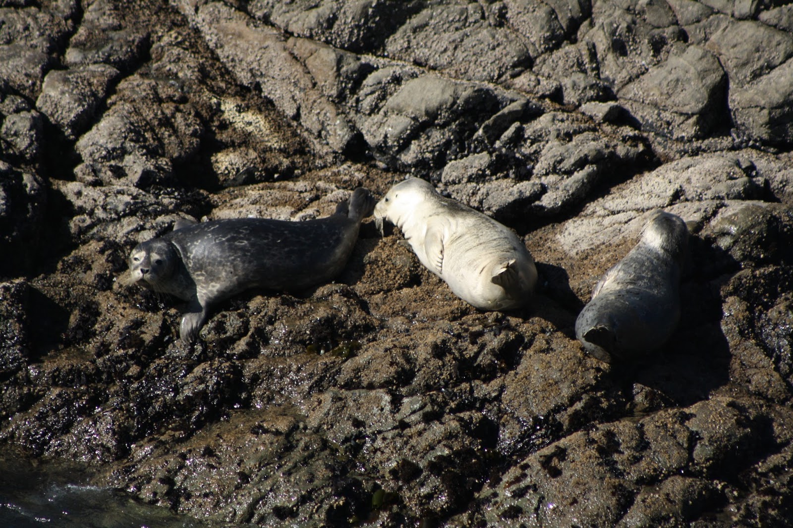 |
| Seals recline on the rocks at Seal Cove. |
An informative sign said that peace-loving Indians lived here before the late 1800’s off the bounties of the sea.
The Sinkyones were nearly exterminated by European explorers and settlers, probably by
exposure to disease. When European travelers traded for furs--and for fish and fresh vegetables to relieve illnesses like scurvy that plagued sailing crews--they unwittingly exposed Indian populations to European diseases like influenza and smallpox. There are various theories about how smallpox was introduced to the Northwest coast, but most historians agree that this deadly disease first began to ravage Indian populations in the region between the mid-1770's and early 1780's. Because Native peoples had never been introduced to the disease, they had no natural immunity, and a virgin-soil epidemic ensued. In combination with other diseases such as influenza and malaria, smallpox wiped out roughly 65% to 95% of Northwestern Indian populations by 1840.
The road through the King Range National Conservation Area wound and twisted
along the sides of the mountains for 20 miles.
It took us 20 minutes to drive six miles—no stops.
 |
| Waves crash at Abalone Point where mountains roll right down to the Pacific Ocean shoreline. |
“Any protected areas are Bureau of Land Management,” said Andy. “Even the Forest Service didn’t want it. But it’s beautiful country.”
 |
| Alternate slopes of pines and grasslands mark the King Range. |
Some of the peaks average 100 inches of rain a year. None for us though. It was very dry with fire danger extreme.
Unpaved driveways suggested people do live tucked away back among the
trees. We took Ettelsburg Road to Wilder
Ridge Road, both hardly more than a one-lane trail—no guard rails, no signs and
a couple thousand feet in elevation.
Eight miles beyond Ettelsburg, we realized we had driven through Ettelsburg
without knowing it. There were four
mailboxes together.
 |
| Honeydew hasn't changed much in the six years since our last visit to the region. |
”Take our picture too,” insisted a spaced-out girl, pulling her black lab
around and making him sit.
It was sad to see lives seemingly wasted.
Steep curves in the road had washed out on either side of
Honeydew. The gravel road had been
graded but not paved.
Twice mother deer crossed our path with their young. Here fall was definitely in the air. Leaves fluttered down and lined the roadside, and hardwoods dotted the hillside with yellow.
 |
| Grazing land seems lush and rich, but we are surprised to see zebras grazing in the field. |
Twice mother deer crossed our path with their young. Here fall was definitely in the air. Leaves fluttered down and lined the roadside, and hardwoods dotted the hillside with yellow.
Being a kid here must be tough:
tiny schools, few sports, no outlets.
The road signs are all shot up with holes, and abandoned cars are spray
painted.
The town of Petrolia marks the site of California’s first oil well, drilled in 1865. The first shipment of crude was sent to a refinery in San Francisco.
The town of Petrolia marks the site of California’s first oil well, drilled in 1865. The first shipment of crude was sent to a refinery in San Francisco.
“I think there is money down in the valley,” said Andy. “This looks like good grazing land.” The fields of natural grass had not been
overgrazed. Just then we rounded a bend
in the road and discovered zebras grazing.
They never even looked up when I got out of the car to take pictures.
 |
| Hardly African savannah, the high fields of King Range apparently make perfect grazing ground for zebras. |
At Russell Chambers Memorial Bridge, the cows grazed right on the
beach.
“Supposedly, the coast here shifted about 12 feet during the last earthquake,”
said Andy.
 |
| A hawk takes off from a fence post as we drive along. |
A hawk, perched right by the road on a fence post, took off as we drove
by. The coastline beach totally undeveloped, spread before us. The grass-covered mountains rolled right down
to accessible beach.
 |
| Privately-owned ranches skirting the mountainsides roll undeveloped right down to the water's edge. |
We stopped right on the water for pictures. Dark clouds hung over the mountain, and the
chilly wind whipped the water. But the
views were stupendous. The water looked
murky close to shore.
“That’s because of the drop in the coastline maybe,” I suggested.
“I don’t know,” admitted Andy. “It’s been lots of years since I read
about it.”
 |
| The beach extends about 12 feet below the roadway along this section of coast. |
We climbed down to the unnamed beach. Thirty m.p.h.sustained winds gusted and swept around us. Climbing back up was an effort.
 |
| King Range peaks roll to the sea along the Lost Coast. |
Up on top of the world, some dark clouds moved in. High chaparral, I called it, where
mountainsides of grass meet the sea.
 |
| Flowers of all kinds bloom along the river walk in downtown Fortuna. |
This was our last day on the coast and the
mountains were making their own weather. They might even make some rain. But it was only a maybe by the time we got back to Fortuna.
mountains were making their own weather. They might even make some rain. But it was only a maybe by the time we got back to Fortuna.
No comments:
Post a Comment