RETIREMENT TRIP#7
Whale Watching and More...
At least 50 little fishing boats anchored in an inlet along the shore
about a mile outside of Garibaldi at 8:15 a.m.
Some carried four or five people with fishing poles draped in the water. Campers with coffee stood by their trailers
on the shoreline watching the show. Now
the sign posted on the wall of our room in the motel last night made sense:
TO OUR GUESTS:
PLEASE DO NOT COOK ANY FISH OR CRAB IN YOUR ROOM.
ALSO, PLEASE DO
NOT SHELL CRAB IN YOUR ROOM,
AS IT TAKES DAYS FOR THE ROOM TO AIR OUT.
KEEP FISH OR CRAB
STORED IN YOUR COOLERS.
CONSULT FRONT DESK
STAFF FOR COOKING/CLEANING LOCATIONS.
 |
| At Wayfinding pullout, early morning fog begins to clear. |
As we drove south along Route #101 toward Hebo, the morning fog
lifted. “I think it’s caused by the
current,” said Andy. “The Alaskan
current offshore is cold, and the land is still warm. It creates the morning mist—the fog
bank—until the sun comes out.”
He was right. The air was really
chilly as we loaded the car and later as we stopped for pictures.
The Wayfinding pullout just south of Pacific City offered beautiful
ocean views. I admired the layers of
color with Queen Anne’s lace still blooming next to the grey stone wall, red
apples hanging from a tree below, the deep blue pond, a red barn and waves
crashing against the blue ocean. Even
the white sand and green vegetation each added layers of color to the panorama.
We stopped at Neskowin Beach State Recreation Site to walk out to the
water. The fog had retreated
somewhat. It clung in a heavy layer just
over the shoreline at 9:30 a.m. Breakfast
cooked in the lodge and restaurant nearby.
We could smell bacon and onions frying.
A prime tsunami area, Road’s End State Recreation Site warned of the
dangers of giant waves caused by earthquakes off shore. Tremors in the Cascadian Subduction Zone,
some 22 to 70 miles offshore, cause repeated tidal waves that can wash several
miles inland. Some of the beach homes
along the water in Lincoln City looked pretty vulnerable. And a super heavy cloud bank right over the
shoreline looked all the more ominous.
 |
| The power of ocean waves is evident at the washout. |
At D-River pullout we “toured” the shortest river in the world at its
mouth. It looked like a drainage
canal. Andy guessed the source was
probably a mile away in Devil’s Lake. That makes sense: “D” River—Devil’s Lake. Near the point at which the water streamed
out to the ocean, hundreds of gulls perched on the sand.
We stopped for coffee in Lincoln City, hoping the overcast would clear
out. Unfortunately, no such luck. It was pretty well socked in…but just along
the coast.
At Gleneden Beach we saw the effects of ocean waves. An entire end of
one fence, undermined from below, hung in the air. The street had been washed away about 50
vertical feet and the cottages on the other side stood precariously close to
the sandy cliff. Huge boulders piled at
the base looked like someone’s attempt to preserve a home. “That owner spent a
lot of money,” said Andy, “but it was pretty much in vain. Those houses are going to go!”
 |
| Boiler Beach offers incredible views of a power sea. |
“If you look that direction,” coaxed Andy, “you’ll see a blow hole spout every so often.”
I waited for the cormorant to reappear and for the blow hole to spout
off.
 |
| Waves ceaselessly pound the coast at Cape Foulweather. |
The next stop was Boiler Beach.
The grey skies were so disappointing, until someone yelled, “Over
there,” and pointed out to sea.
I had been watching a small boat with three people on board. Two in orange vests stood on the deck and a
third balanced as a spotter on a forward platform. Andy thought initially they were
fishermen.
“
There,” the voice called again, and we saw a whale spout. Then a couple others surfaced. We watched for at least 15 minutes, fascinated
by the action. I even got a picture of
one swimming by the boat. It had to be a
whale watching vessel.
 |
| Each view is more spectacular than the last along Oregon's rugged coastline. |
At Depoe Bay, the Whale Watch Beach was crowded with people. We found parking, but the best shot wasn’t of
whales. It was the coast line adjoining
the beach.
“It’s ironic that Cape Foulweather has the best weather of the day,”
said Andy, as we got out of the car.
Others were bundled, but it was almost warm enough to shed jackets.
We walked the crest trail and looked for whales. An old grey whale surfaced long enough for me to snap a picture, but we never saw the little seal that some said resided down below on the rocks.
We walked the crest trail and looked for whales. An old grey whale surfaced long enough for me to snap a picture, but we never saw the little seal that some said resided down below on the rocks.
 |
| Waves crash against the shoreline at Otter Crest. |
Four more whales were feeding off Otter Crest Viewpoint. Not only did they surface, but every so often
we would see the spray spout. To the
left, gigantic breakers hit the rock ledge, sending spray in huge showers. “It’s a good thing I don’t live here,” I told
Andy. “I would be glued to the
binoculars!” I didn’t want to leave.
 |
| Driftwood logs form a beach shelter and a posing prop for Andy. |
“We’re really high up now,” said Andy at the next loop pullout. We could see the Devil’s Punchbowl from the
top of the crest.
At the Cape Foulweather Gift Shop, where I bought lighthouse salt and
pepper shakers six years ago, elderly viewers crowded the windows to watch grey
whales feed right along the coast.
 |
| This is one of many grey whales feeding along the Oregon Coast. |
Closer into town were more whales, more views of Devil’s Punchbowl and
a few more tourists. The sun broke
through, warming the air enough to shed jackets, but a foggy mist cut off the
beautiful blue for photography.
 |
| This stump belongs to a Sitka spruce that was 4,100 years old. |
A huge log jam blocked the mouth of Spencer Creek where it dumped into
the ocean. Since the tide was going out,
we managed to pick a path across the rounded rocks and jump across the water to
sandy dryness. There an ancient stump
covered the ground. The mass of
petrified wood once supported a Sitka spruce, buried in the sand when it
dropped off into the sea. Preserved for
4,100 years it surfaced in 1998 and was washed down to the mouth of Spencer
Creek in 1999.
 |
| Yaquina Head Light Station dominates the promontory. |
On the other side, visitors had built two beach shelters out of piled
driftwood, a lady tossed tennis balls for a golden retriever, and a group of
about 20 college-aged kids played beach soccer against an ocean and cliff
backdrop. One team rallied when a female
player earned them a penalty kick.
Yaquina Head Lighthouse charged admission to the park, but visitors
with Golden Age passports were free. I
guess it’s nice to be old!
Yaquina Head is a narrow, coastal headland formed by ancient lava flows. The basalt cliffs and coves have endured the pounding ocean surf for 14 million years.
Yaquina Head is a narrow, coastal headland formed by ancient lava flows. The basalt cliffs and coves have endured the pounding ocean surf for 14 million years.
 |
| Flowers cling to the rock in the cleft of the cliff at Yaquina Head Light Station. |
 |
| Sea anemone and sea urchins decorate the tidal basin at Yaquina Head Light Station. |
We spent an easy 45 minutes balancing on the trillions of rounded rocks that lined the beach and exploring the tide pools for mussels, sea anemones, urchins and whelks. Twice I sat down unexpectedly as pebbles tumbled under my feet, but the barnacles made for secure footing at the water’s edge.
 |
| Resistant basalt piles weather the waves outside of Yaquina Head Light Station. |
The area was first identified by Captain James Cook, when he anchored
approximately ten miles offshore on March 7, 1778. President Andrew Jackson signed an Executive
Order in 1866 that set aside 19 acres for a light station to be constructed at
Yaquina Head. Finally, in 1980, a
100-acre site was established by Congress as an Outstanding Natural Area to be
managed by the Bureau of Land Management.
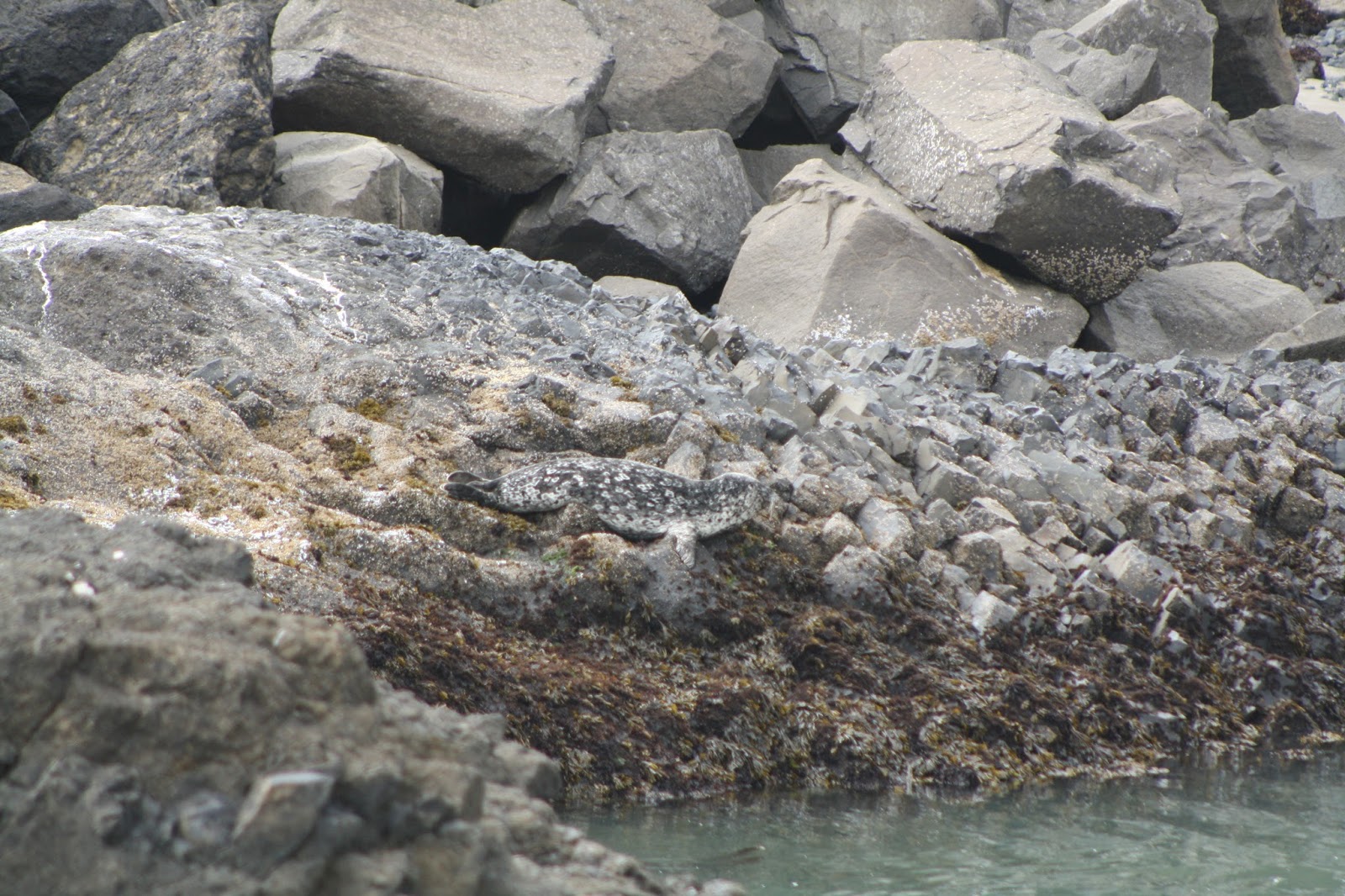 |
| A seal rests on the rocks of Quarry Cove at low tide. His camouflage coloring blends perfectly with the rocky coast. |
At the end of the Quarry Cove Trail near the base of the basalt cliff,
an elderly lady from Portland helped us identify a grey harbor seal resting on
the rocks. “It’s unusual to see him
there at low tide,” said the lady. “The
ranger was saying that someone heard it coughing so it could be sick.” He blended in perfectly with the rock.
Late in the day we parked in downtown Newport at Yaquina Bay. It was a long and sandy walk across the beach
to the water, but from the shoreline we could see all the way up the beach ten
miles to the lighthouse on Yaquina Head.
 |
| By late afternoon the Port of Newport is quiet, except for the sea lions. |
 |
| With their own platforms for sleeping, sea lions recline on the dock at Newport waterfront. |
Exiting the car and walking a few blocks to the scene of the racket, we
learned the truth. Sea lions, not seals,
have taken over the Port of Newport.
Sea Lions have ear flaps and large front flippers which they use to move on land and swim. California Sea Lions are dark brown and sound like barking dogs. Steller Sea Lions, a federally threatened species, have light brown or auburn fur and sound much like roaring lions. Seals, unlike sea lions, lack external ear flaps and have smaller flippers. On land they move clumsily by flopping on their bellies in an undulating motion called galumphing, but in the water they gracefully propel themselves with their rear flippers.
Sea Lions have ear flaps and large front flippers which they use to move on land and swim. California Sea Lions are dark brown and sound like barking dogs. Steller Sea Lions, a federally threatened species, have light brown or auburn fur and sound much like roaring lions. Seals, unlike sea lions, lack external ear flaps and have smaller flippers. On land they move clumsily by flopping on their bellies in an undulating motion called galumphing, but in the water they gracefully propel themselves with their rear flippers.
Lining the dock area were hundreds of sea lions, all squawking for dock
space and fighting for room. We read
informative signs in the viewing area:
males grow up to 1,000 pounds and eat 5% to 8% of their body weight a
day. Squid, octopus and fish is the
preferred diet. And that’s at least 50 pounds
a day! Females often reach 250 pounds in
weight.
Like us, the tourists were fascinated with their angry antics.
But it's no wonder fishermen hate sea lions!
Like us, the tourists were fascinated with their angry antics.
But it's no wonder fishermen hate sea lions!
No comments:
Post a Comment