RETIREMENT TRIP #7
I Could Live Here...
This morning the coast was clear, but clouds hugged Coos Bay.
“That does it,” said Andy.
“We’re going back to Arago again.”
 |
| Shrouded in fog the day before, Cape Arago Lighthouse is visible in the early morning. |
 |
| Seals and sea lions crowd Simpsons Reef until living quarters entail being pushed into the sea. |
We headed back to the Oregon beaches.
The sun finally popped through at Simpson Reef Overlook. It was 58 degrees at 9:30 a.m.
 |
| On the smaller adjoining islands at Simpsons Reef, one male dominates his clan and barks commands. |
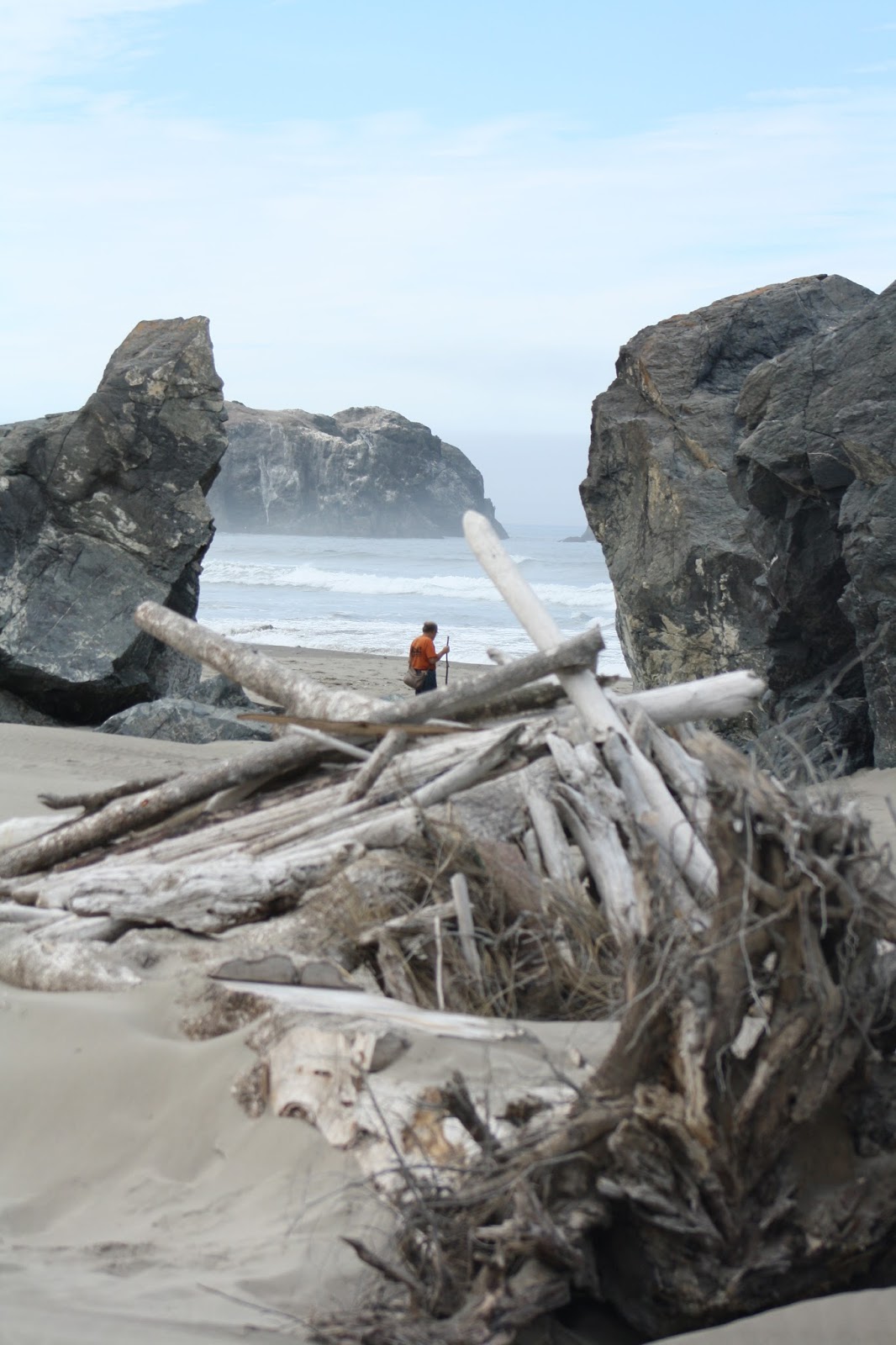
Someone was down at Arago Beach South where we had seen the dead seals
yesterday. We could see the yellow
poncho bent over among the rocks. But
for us it was time to move on. Sun
flirted with clouds as we hit the road with the weekend tourists.
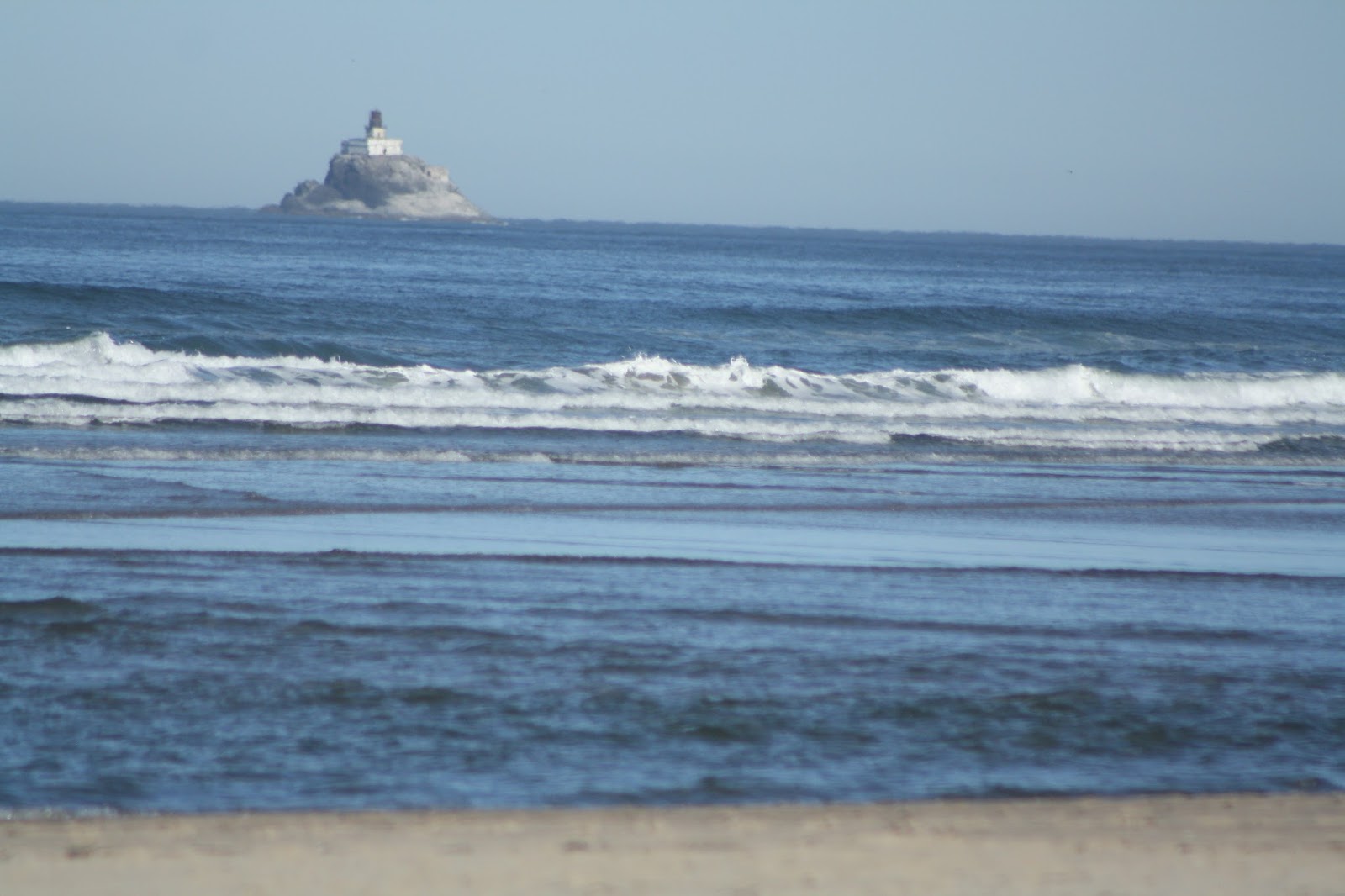
As we left the park, we spotted Cape Arago Lighthouse far out on a
point. It had been shrouded in fog
yesterday and wasn’t visible from the beaches, only from one small pullout. But how lovely it looked in the morning
sunshine!
We took the scenic Seven Devils Road to Bandon. The drive passed by huge tracts of timber at
all different stages of growth.
“I think they cut on a 60-year cycle,” said Andy.
 |
| Coquille River Lighthouse flashes a stationary light to mark the river harbor. |
There were tracts of mature pines, sections of growing young trees and
areas of dead roots that could be nurturing newly planted seedlings. Some areas looked burned over; some were
devastated and untouched. What houses
were interspersed between tracts showed abject poverty—dumpy trailers, broken
doors, missing shingles, roaming chickens all marked a very poor part of the
state.
At Merchants Beach an informative sign said that Charles Merchant ran a
thriving business here in the late 1800’s.
He married and had 16 children, most of whom lived to adulthood.
Andy laughed. “You know what
they were doing during all the lousy weather!”
He pointed out that no one lived nearby now. “You know the weather here must be lousy when
no one wants beach property.”
 |
| As Andy poses on the rock ledge, the tide surprises Sue down below. |
In spite of clouds the sun was out when we pulled into the parking area
at Coquille River Lighthouse after a few miles of driving across sand
dunes. We took a path around the old
building, picking our way carefully over the jagged basalt exposed by the tide.
“This way,” called Andy, ahead of me as usual. “You can do it. Come down here.” He was standing on barnacle-crusted rocks
just above the water line of the Coquille River, and the tide was coming in.
I stepped gingerly, balancing both cameras.
“Here!” he called. “You have to
get a picture from here!”
Holding my hand, he led me emphatically to his spot on the edge of the
water. Then he clambered 20 feet up the
rock to a boulder. “Now take the
lighthouse and me,” he called from his perch.
 |
| From across the river in Bandon, the Coquille River Lighthouse dominates the river harbor entrance. |
Inside the Coquille River Lighthouse, Host David told us the story of
the Coquille River Light. Gracious,
personable and highly informative, he shared his knowledge. The lighthouse, constructed in 1896, marked
the entrance to the harbor with a stationary light—28 seconds on and two
seconds off. Rotating lights
distinguished shoreline. Coquille River
was a river harbor, so it didn’t rotate.
 |
| On Bandon Beach across from the lighthouse, Sue rests on a piece of driftwood log. |
In 1896, the lighthouse guided ships across a dangerous bar and up to
the river port. Improvements in the
river channel and navigational aids made it obsolete.
The lighthouse, decommissioned in 1936, was restored in 1978. For a time it was used by the Coast
Guard. It was painted the original
colors—the only two colors available in the nearby shipyard in 1896. That’s how it got to be cream and red, the
colors normally used for the boats.
Two families and three shifts of male workers lived in the house
adjoining the lighthouse when it was in operation. The men had to bunk in the attic. David told us that when the fire was really
burning in bad weather, it took four shifts of men to keep it stoked so the
kerosene-fired wick wouldn’t go out.
Then shippers depended on the lighthouse for location. The light shines from atop a 40-foot
octagonal tower.
 |
| From every direction and every angle, Bandon Beach is a gem of beauty and cleanliness. |
Across the river was the town of Bandon, founded by Lord George Bennett
from Ireland and named after the town he came from. He brought with him a plant called gouse, a
green ground cover that animals don’t eat because of its sharp thorns. Gouse offered a great stabilizer for dunes,
but the invasive has now taken over the area.
 |
| Interspersed rocks and driftwood line Bandon Beach as the tide recedes. |
 |
| Blue sky and blue ocean meld together at Bandon Beach. |
At another point in time when the jetty was being built a large boat got
struck on the pebble fill at low tide.
It was so buried that no one could float it out. Ultimately, the owner stripped it of everything
valuable, cut off the whole top and left it.
The men who built the jetty filled it up with sand and stone and just
used the whole craft as jetty.
Host David said the same thing happened with some railroad cars. They were just disposed of by dumping them
over the edge. I guess they can still be
spotted far out on the jetty at low tide.
 |
| Pictures of Bandon Beach are worth a thousand words! |
Leaving the lighthouse, we walked Bandon Beach. “I could live here,” said Andy.
I totally agreed with him. The
tide had started to come in and a few lone seagulls scoured the sand for
morsels. The tide was carrying in bits
and bites.
 |
| From far off we can see Coquille River Lighthouse in the distance. |
Waves crashed against the
rocks just offshore, sending spray in sheets of white. Beautiful beach homes dotted the crest above
us, but the sand was public property.
People here respect that. There
wasn’t a piece of litter or a trash can anywhere—only the driftwood tossed up
by the ocean and the pieces of crab shell left by the gulls. We could still hear the fog horn blasting its
mournful warning.
A little farther down the coast we parked at Oregon Island National
Wildlife Refuge. A public trail skirted
the top of the cliff and gave us fantastic views of the coast. We could even see Coquille River Lighthouse
far in the distance.
 |
| From the public trail at Oregon Islands National Wildlife Refuge, we learn about native species as well as enjoying the scenery. |
I read about the
Puffins that live on Face Rock. Their
eggs are pear-shaped so they only roll in circles and don’t fall off the cliff
edges. Uniquely spotted in black, blue
and white, the single egg per year per pair of Puffins is identifiable by the
parents.
Another colorful sign explained that the islands offshore were rocks of
blueschist, igneous lava that had been subjected to special conditions of heat
and pressure, as well as salt water.
 |
| Oregon Islands National Wildlife Refuge protects nesting areas for waterfowl, as well as the overall environment for sea mammals. |
Bandon Wayside offered three stops.
We explored the first—Devil’s Kitchen--walking along the grassy crest
for views of the ocean. A bright sun
warmed the land. At first a blanket of
fog and mist swept past as the tide turned.
Then, as the ocean retreated and the land warmed, the tide carried the
fog bank out to sea. We had timed things
perfectly.
 |
| Sue takes an unexpected plunge in the Pacific Ocean at the Devil's Kitchen. |
“Let’s go down to the water,” said Andy.
This time I took off my shoes before they filled with sand. We trod across the expanse, sinking as usual
into the soft, white grains.
“I’ll walk along the very edge as the waves lap up,” I told Andy, as I
rolled up my pants legs. “You can take a
picture.”
He took the camera, but just as I turned to pose, a large wave caught
me off guard. Andy snapped the picture
and dashed farther up the beach. I stood,
water swirling to my knees. And it was
COLD! What was the lesson? Don’t turn your back on the ocean?!
“I don’t see any devils here at Devil’s Kitchen,” joked a tourist just
coming down to the water.
“Just go in the surf,” I told him.
“Oh yeah!” he laughed.
“Ice! Isn’t that one of Dante’s
levels of Hell?”
 |
| Cape Blanco Lighthouse dominates on land as well as sea. |
Andy looked at my pants. “Now
you know why no one goes swimming here,” he teased.
Cape Blanco Lighthouse offered paid tours. We walked around the outside, took a bunch of
pictures and tried to find a trail down to where seals yakked. There were no trails, but the access road had
a pullout with a view of the rugged coastline.
“There’s a lot of guano on those rocks,” said Andy.
“Maybe that’s why it’s called Cape Blanco,”
I told him.
He knows enough Spanish to get that!
At Sixes River, we hiked a trail from Hughes House Campground—the
Coastal Trail—only Andy chose the river branch.
Turns out that wasn’t the Coastal Trail at all. We followed a narrow path through a sheep
pasture and along the river for most of a mile and out to a beach on a quiet
bay.
 |
| A hiking trail follows the Sixes River to a secluded ocean beach. |
Then Andy decided we should loop
back. The beach was easy; but then we bushwhacked—across
a stream, over tons of driftwood twigs and into fields of waist-high grass. Eventually, far ahead of me, he spotted the
Coastal Trail.
“It’s okay,” he called from 100 yards away. “Just follow the path I made through the tall
grass.”
Like I could see a path! The
grass was up to my eyeballs!
 |
| This view from our motel in Port Orford disappears as the fog rolls in overnight. |
Port Orford Lifeboat Station and Museum was closed, but we checked out
Lifeboat 36498 on display outside. The
motor boat, self-righting and self-bailing, was built in Maryland at a cost of
just over $23,000. It was the boat of
choice for water rescue.
At Tseriadun State Recreation Site, we walked the black sand beach before
dinner. A gentle mist dotted the
windshield. No matter. We had lucked out with a gorgeous day.
 |
| At the Tseriadun black sand beach, citizens are reminded to keep the beach clean by picking up debris. |
Signs encourage
citizens to clean up the beach when debris washes on shore. Andy picked up a
piece of orange rubber and tossed it in the garbage can. We did our part!
“I could live here,” Andy repeated, as we drove to dinner, “but only
for four months a year.”
No comments:
Post a Comment